
The book contains materials on the search for modern and buried alluvial and primary deposits of diamonds. Much attention is paid to prospecting testing of potentially diamondiferous deposits and provides information on all types of diamondiferous rocks currently known. It is addressed primarily to young geologists who have embarked on a search for diamond deposits. It will find the answer to many questions by many geologists, prospectors and prospectors, leading the search for gold and diamonds. While this information product, for the most part, is in the public domain, it also may contain copyrighted materials as noted in the text. Permission to reproduce copyrighted items must be secured from the copyright owner.
diamonds, deposits, Basaltoids, Impactites, Tuffisites, Metamorphites, Lamproites, Kimberlites, placers, Angarida
RUSSIAN ACADEMY OF SCIENCES
SIBERIAN BRANCH
INSTITUTE OF THE EARTH'S CRUST
Nikolay Ivanovich Akulov
SEDIMENT TESTING
DURING DIAMONDS SEARCH
Scientific editor
Doctor of Geological and Mineralogical Sciences
A. V. Tolstov
RUSSIAN ACADEMY OF SCIENCES
INSTITUTE OF THE EARTH'S CRUST
N.I. Akulov
TESTING OF SEDIMENTARY
DEPOSITS AT
DIAMOND SEARCHING WORKS
Scientific Editors
D. Sc. in Geological and Mineralogical Sciences A.V. Tolstov
The book contains materials on the search for modern and buried alluvial and primary deposits of diamonds. Much attention is paid to prospecting testing of potentially diamondiferous deposits and provides information on all types of diamondiferous rocks currently known.
It is addressed primarily to young geologists who have embarked on a search for diamond deposits. It will find the answer to many questions by many geologists, prospectors and prospectors, leading the search for gold and diamonds.
While this information product, for the most part, is in the public domain, it also may contain copyrighted materials as noted in the text. Permission to reproduce copyrighted items must be secured from the copyright owner.
Suggested citation:
Akulov N.I., 2022. Testing of sedimentary deposits at diamond searching works.
Irkutsk, Academic Publishing IOTEC, 140 p.
ISBN 978-1-922756-10-7
K 549.12
LBC 26.31
А 941
Akulov N. I.
Sediment Testing During Diamonds Search
Sci. ed. A.V. Tolstov
The Russian Academy of Sciences; Siberian branch;
Institute of the Earth's Crust (IEC).
Irkutsk, 2022.140 p.
ISBN 978-1-922756-10-7
The book contains materials on prospecting for modern and buried alluvial diamond deposits. Much attention is paid to prospecting testing of potentially diamondiferous deposits and information is given on various types of diamond-bearing rocks known at present.
It is addressed primarily to young geologists who have embarked on prospecting for diamond deposits. They will find there the answer to many questions geologic-prospectors and prospectors conducting searches for gold and diamonds.
Reviewers:
Dr. of Geol. and Min. Sciences S. I. Kostrovitsky
Dr. of Geol. and Min. Sciences V. A. Skvortsov
Cand. of Geol. and Min. Sciences S. A. Prokopiev
© N. I. Akulov
ISBN 978-1-922756-10-7
List of content
BY EDITOR………………………………………………………………………………………………….………………………………….5
INTRODUCTION………………………………….…………………………………..………………………………….....................7
1. THE PHILOSOPHY OF SEARCH AND THE BASIS OF GEOLOGICAL JURISPRUDENCE
1.1. Specifics of acquiring the right to use subsoil
3. GENETIC TYPES OF DIAMOND-BEARING ROCKS
4.1. Weathering crust of kimberlites
4.2. Types of diamond placers and tasks of the first stage of their search
5. TYPES OF TESTING WORKS IN SEARCHING FOR DIAMONDS
6. METHOD OF OBTAINING DIAMOND-CONTAINING CONCENTRATES IN FIELD CONDITIONS
6.1. Elementary Jigging Basics
6.2. Obtaining concentrates using jigging devices
7. SCHEMES OF ENRICHMENT OF DIAMOND-BEARING SEDIMENTS
7.1 Features of laboratory studies of concentrates
8.3. Deluvial-proluvial placers
8.4. Buried placers of Angarida
8.5. Riphean sources of diamonds in the south of Angarida
8.6. Coastal-sea placers of Angarida
9. PRELIMINARY WORKS FOR DIAMONDS IN THE SOUTH-EASTERN PART OF THE SIBERIAN PLATFORM
9.1. Conditions for the accumulation of diamond deposits in the Angara region
9.2. Composition of diamondiferous deposits of the Tusham paleobasin
10. THE STORY OF ONE DISCOVERY
BY EDITOR
The relevance of this work, despite its seeming archaism is quite high, oddly enough. Prospecting for diamonds is in many ways specific, and, first of all, due to the peculiarities of the object itself, which is a unique mineral from many sides. Diamond with a higher specific gravity like its invariable companions, better known as indicator minerals of kimberlite (magnesian garnet pyrope, picroilmenite, olivine, chrome diopside and chrome spinels), is much lighter than traditional, from the point of view of prospectors, useful components, such as, first of all, gold. And if, we use the traditional method during diamond prospecting operations, which has proven itself for hundreds of years in the search for gold, when the sampled material that entered the schlich sample, after "elutriation", "cut-off" and sieving by fractions, is blown in a tray to black concentrate, then diamonds, as well as the indicator minerals of kimberlite, there can be definitely no more in the concentrate. This is the main specificity, the main problem and the main mistake of novice diamond prospectors. "Gray concentrate" is the only opportunity to identify diamonds or kimberlite indicator minerals in sedimentary deposits in new territories, regardless of their genesis.
Therefore, the author devotes rightly a lot of time to the sampling method and the peculiarities of sample washing, in particular, the problem of choosing a sampling point, which, as a rule, a geologist should outline directly in the field. Surely, this should be the most informative part of the river-bed sediments, as a rule, the so-called "spit head", where the maximum amount of the heavy fraction, including diamond and indicator minerals, will be concentrated. At the same time, the author paying apparently tribute to history, gives numerous, and sometimes overly detailed examples of sampling from various sediments, referring mainly to the experience of work in the 40s - 60s of the last century.
It should be given credit that the author notes that it is also in many respects specific characterizing the material entering the sample. It will not necessarily be a classic coarse-grained, well-sorted and washed oblique material. Quite the opposite, often the deepest near-bedrock, clayey part of the section should be taken into the sample, where the maximum amount of minerals of the heavy fraction can be concentrated, which is rightly emphasized by the author.
The proposed monograph is devoted to the features and specifics of sampling of sedimentary deposits during diamond prospecting. However, in fairness, the author manages to tell about the history of the development of the Siberian platform, starting from the Paleozoic, the time of the formation of productive kimberlites, as well as about the history of prospecting for diamonds in Siberia. The Institute of the Earth's Crust, in the depths of which this monograph has matured, glorious history of prospecting for diamond deposits on the Siberian platform, dated back over 70 years. Thanks to generations of Irkutsk scientists and geologists, the methodology has improved in relation to various geological settings, before spilling into this thorough work, claiming to be fundamental. Much of the author's ideas in the monograph has been translated into reality, the necessary corrections were made in a timely manner, in the course of work with the editor.
The confidence of the author of the monograph that new discoveries of diamond deposits on the Siberian platform are still ahead is conveyed to the readers. And it is no coincidence that, completing the work, the author dwells in a very original way on the history of one of the last vivid and real discoveries of diamond deposits. He focuses on the final stage of the diamond rush in Canada, to which our compatriot, a geologist of the Soviet school, who had gone through more than a dozen field seasons in Yakutia and received a wealth of experience in prospecting for diamond deposits.
It is very noteworthy and symbolic when a convinced geologist, proving his innocence, persistently goes to the intended goal and, as a result, finds a deposit contrary to the opinion of the authorities and the confidence of the majority, in defiance of the leadership. This is a worthy and instructive example in many ways, when the result of many years of creative work, multiplied by experience, finds its embodiment in such a bright discovery. The example given by the author will allow young subsoil explorers to believe in their strengths and capabilities, to be inspired by the confidence that new discoveries are ahead. It is hoped that this monograph will contribute to this.
This monograph, according to the editor, deserves to be published and accessible to every novice young geologist who has devoted himself to prospecting for diamonds.
Director of RGE AK ALROSA (PJSC),
Discoverer of the "Mayskoye" diamond deposit,
Honored Geologist of the Republic of Sakha (Yakutia),
Honored Geologist of the Russian Federation,

Doctor of Geological and Mineralogical Sciences A. V. Tolstov
07.09.2021
Novosibirsk c.
INTRODUCTION
Many researchers, embarking on prospecting for diamonds, are not familiar with this area of the geological service, and therefore face a number of difficulties. In addition, every year young specialists who have no experience in sampling diamond-bearing formations come to diamond prospecting expeditions. The main purpose of this book is to provide practical assistance to prospecting geologists involved in the search for primary sources of diamonds.
The application of the methodological techniques given in this work will allow obtaining extensive geological prospecting information, the completeness and quality of which is sufficient for making decisions on further search for diamonds.
The relevance of prospecting for diamonds is well known. At all times, there have been enthusiasts and romantics who go in search of natural resources. One of them are geologists specilizing in diamonds. The knowledge and skills set forth in the book will assist them in conducting prospecting work.
The methodological basis for writing this book was the author's personal experience gained during diamond exploration in the middle reaches of the Viluy river, on the Nizhnyaya Tunguska river (Preobrazhenka-Krasnoyarovo region), on the Tanguy-Udinsky and Ilimo-Katangsky confluences, as well as scientific works and publications of famous domestic and foreign geologists. The purpose of writing this work is the author's aspiration to give the reader a broader understanding of geological methods and techniques for conducting diamond prospecting.
Prospecting research is always associated with sampling promising (potentially diamondiferous) deposits and obtaining concentrates. A detailed study of which was previously carried out only in stationary laboratories, and is now being carried out in the field.
The sampling schemes presented in the work were drawn up taking into account the minimum financial costs for extracting diamonds and their satellite dikes from concentrates. The choice of a particular sampling scheme depends entirely on the type of diamond-bearing deposits and their mineralogical composition. So, when processing samples represented by loose sandy-clayey and boulder-pebble formations, the enrichment scheme is relatively simple. When sampling cemented diamondiferous rocks, represented by sandstones, gravelites or conglomerates, crushing aggregates and automatic screens with specially trained personnel appear in the enrichment scheme.
It is important to note that prospecting for diamonds is in many respects identical to prospecting for gold, platinum, silver, copper and other types of mineral raw materials. All of them are objects of various studies, but they are united by one natural property, a large specific gravity. Therefore, in the process of sizing, they end up in a concentrate (heavy fraction). In our case, the target for prospecting work is diamonds. Diamonds and diamond satellite minerals (MSA) define and direct the further procedure for prospecting sampling of sediments in order to obtain a concentrate for a more detailed laboratory study, the results of which will form the basis for further search for their primary deposit.
Information on conducting prospecting testing, set forth in various monographs and methodological recommendations, starting from V. M. Kreiter (1940) and ending with the manual on geological survey at a scale of 1:50000 (Methodical manual ..., 1978), as well as various sampling manuals (Prokopchuk, 1979; Methods of selection ..., 1984), do not give a complete picture of this process.
At the end of the last century, various requirements and instructions for conducting geological survey work for diamonds were published, which did not significantly clarify this issue (Instructions for compiling ..., 1995; Cameral processing ..., 1999; Field research ..., 2000, etc. .).
The main task facing the author was not to describe expensive methods for the comprehensive study of promising territories using aeromagnetic surveys, geochemical methods of research and drilling, but based on modern knowledge and means of small-scale mechanization, promptly search for primary sources of diamonds in a small detachment.
This work is a revised and supplemented edition of the methodological manual “Sampling of potentially diamondiferous deposits and prospecting for diamonds placers” (Akulov, 1992), which was approved by such remarkable geologists, discoverers of diamond deposits, such as V. N. Shchukin (pipes Udachnaya, Sytykanskaya and Aikhal), B. M. Vladimirov (diamondiferous dikes of the Sayan region and kimberlite fields of West Africa), G.Kh. Feinstein (Yakutian diamondiferous province). The wishes and comments expressed by them were taken into account in this edition.
It should be noted that the first edition was very popular among geology students. According to the “teacher of teachers” S. N. Kovalenko, who turned to me with a request to republish it, is a handbook for students when writing term papers on placers.
The author is deeply grateful to B. M. Vladimirov, S. F. Pavlov, V. N. Shchukin, A. E. Bessolitsyn, K. N. Yegorov, S. A. Kashik, I. G. Korobkov, A. I. Melnikov and V. S. Imayev, who showed great interest in this work and made a number of valuable suggestions and comments that contributed to its improvement.
Special thanks to the reviewers: Doctor of Geological and Mineralogical Sciences, Professor V.A. Skvortsov and doctor of geological and mineralogical sciences, diamond geologist (kimberlitch) S.I. Kostrovitsky, as well as a specialist of the highest category in the field of sampling and enrichment of gold and diamonds, candidate of geological and mineralogical sciences S.A. Prokopyev, undertaking the work of reviewing the monograph and noting its great importance and relevance.
1. THE PHILOSOPHY OF SEARCH AND THE BASIS OF GEOLOGICAL JURISPRUDENCE
After the collapse of the USSR and the liquidation of the Ministry of Geology, a crisis hit in Russian geology. The Marxist-Leninist direction of development of the national economy has ceased to play a leading role in the country's economy. While in the "battles for history" Russian philosophers-skeptics are fighting Anglo-American hyperglobalists (colonialists), we are trying to understand at what social stage of development is domestic geology.
At present, the philosophy of conducting geological surveys in Russia is clearly divided into two stages - Soviet and neo-capitalist (modern). If in Soviet times prospecting work in geological surveys parties was accompanied by transparencies and slogans calling for geologists to discover new mineral deposits for the national economy, then after the collapse of the USSR, domestic neo-capitalists began a rapid division among themselves of all explored mineral resources of the country's resources. They were dividing them into distributed and unallocated subsoil use funds (RF Law ..., 2008).
In Soviet times, geological prospecting works were poorly supported by a material base, but they had tremendous fortitude and an indestructible search enthusiasm. Soviet geologists worked wonders, sparing neither time nor health. Deposits were discovered for the future. The liquidation of the USSR Ministry of Geology and the distribution of permits for the right to use subsoil to individuals and legal entities led to the emergence of a new type of people - subsoil users. It turned out that a subsoil user is a subject of entrepreneurial activity, regardless of the form of ownership, including a legal entity or a citizen (colonialist) of another state. It is empowered to engage in the corresponding type of activity in the use of subsoil by the legislation of the Russian Federation and the legislation of the constituent entities of the Russian Federation (Order ..., 1998).
The unallocated fund consists of unused subsoil plots where it is possible to carry out geological survey for the development of subsoil use objects, but permits are not issued to anyone. Thus, the main part of the economically efficient operating and already explored by the state deposits of various minerals, including diamonds, found new owners i.e. subsoil users, represented mainly by colonists (shareholders of various countries and metropolises, the main goal of which is aimed at personal enrichment through export port of natural resources of Russia). There were new requirements and procedures for considering applications for obtaining the right to use subsoil for the purpose of geological study of subsoil areas, for the purpose of collecting mineralogical, paleontological and geological collection materials (Order ..., 2004a; 2004b; 2005), which were subsequently clarified by the Ministry of Natural Resources and Ecology of the Russian Federation (About introduction ..., 2017).
1.1. Specifics of acquiring the right to use subsoil
In accordance with Art. 11 of the Law of the Russian Federation No. 2395-1 of 21.02.1992 "On Subsoil", the provision of subsoil for use, including their provision for use by the state authorities of the constituent entities of the Russian Federation, is issued with a special state permit in the form of a license for geological survey as well as exploration and mining.
A license can be obtained on the basis of the application principle without holding a tender or an auction on the fact of “pioneering” subject to the following restrictions (order of the Ministry of Natural Resources of Russia No. 583 dated November 10, 2016):
- There is already data on the presence of reserves of solid minerals or probable resources of solid minerals of category P1 or P2 for the declared area. In case of discovery of oil or gas, if there is already data on the probable resources of hydrocarbon raw materials of category Dо or Dl;
No more than 3 subsoil plots can be obtained per applicant for the purposes of geological exploration, the size of each of which is no more than 100 km (this rule does not apply to "Rosgeologia" JSC - clause 1.8 of the Order of the Ministry of Natural Resources of Russia No. 583 dated November 10, 2016).
When establishing the fact of the discovery of a mineral deposit on a subsoil plot of federal significance (hereinafter referred to as SPFS) or on a subsoil plot that is classified as a subsoil plot of federal significance as a result of the discovery of a mineral deposit, the right to use such a subsoil plot is granted only on the basis of decisions of the Government of the Russian Federation. The subsoil plots of federal significance includes areas with recoverable oil reserves of more than 70 million tons, with primary (ore) gold reserves of more than 50 tons, etc.
It is necessary to pay a one-time payment when a subsoil user opens a deposit and for obtaining the right to use subsoil under a combined license for the mining and prospecting of a mineral in accordance with Art. 39 of the Subsoil Law. In the environment of subsoil users, such a one-time payment is called a “fine for the discovery of a deposit”. The procedure for determining the size of a one-time payment for the use of subsoil is established by the Rules approved by the Government of the Russian Federation dated February 4, 2009 No. 94. The size of a one-time payment is equal to 10% of the estimated amount of mineral extraction tax (MET) received from the planned average annual howling capacity of the mining organization.
The total period for issuing licenses should not exceed 65 days (clause 15 of the Regulation on the issuance and renewal of licenses). The flow chart is reduced to the following steps:
- publication of the order of Rosnedra or its territorial body on the registration of a license for the use of subsoil;
- registration and signing of 2 copies of licenses from the head or authorized deputy head of Rosnedra, or its territorial body;
- direction for registration of a license for the use of subsoil;
- registration of a license for the use of subsoil;
- issuance of a license to the applicant.
According to the information published by the editors in the "Zoloto i Tekhnologii" magazine No. 4, 2018, the average estimate of a turnkey diamond pipe search abroad is about $ 7 million, and a large liquation-type nickel, nonferrous or precious metal deposit is $ 500 mln. The search for a diamond pipe within the Yakutsk diamond-bearing province previously cost about 2 billion rubles. (about $ 30 million).
The license is issued for five years, and the procedure for further actions is carried out according to the scheme:
- obtaining a license;
- writing a project for search and evaluation;
- obtaining a positive expert opinion on the project;
- obtaining permission to conduct geological survey without the right to cut forest plantations.
It is interesting to note that in Canada in the period from 2004 to 2014, junior companies accounted for 75% of all discovered fields with annual investments of about $ 1.7 billion. In Australia, the share of juniors does not exceed $ 22.4 million, while during the same period the number of discovered fields increased from 55 to 66%.
In conclusion, it should be said that the philosophy of diamond prospecting has a special theoretical status. The initial stage of the search involves the selection of a promising research area, which, first of all, must meet the following three rules:
- rule of Clifford (Clifford, 1966): “… diamondiferous kimberlites are always coincide with cratons of the Archean consolidation”;
- rule of group intrusion from one ultrabasic source: “... there are no single-located kimberlite pipes, finding a new pipe is a sure sign of the presence of a new kimberlite field”;
- rule of placing kimberlite bodies on positive geological structures: “… diamondiferous kimberlite bodies are always located on positive structures of platforms (anteclises, shields and uplifts)”.
2. DIAMONDS OF RUSSIA
On the territory of the Russian Federation (East Siberian diamondiferous province) in the process of schlich-mineralogical research the the VSEGEI staff L. A. Popugayeva and N. N. Sarsadskikh discovered the first kimberlite pipe “Zarnitsa” in 1954. Several decades have passed and in 2017 in St. Petersburg (FSBI VSEGEI) the first working meeting of companies-subsoil users of the diamond mining industry was held (Fig. 1) “Scientific, methodological and technological problems of forecasting and searching for low-contrast kimberlite pipes in East European and East Siberian diamond-bearing provinces”. The Program Conclusion noted:

Fig. 1. Subsoil users of the Russian Federation. Session of the workshop on June 8, 2017 in St. Petersburg (Photo by FSBI VSEGEI).
- In terms of diamond reserves, the Russian Federation ranks first in the world. The reserves of 80 deposits amount to 1.2 billion carats, including one billion carats of proven reserves are concentrated in three constituent entities of Russia: the Republic of Sakha (Yakutia), the Perm Krai and the Arkhangelsk Oblast.
- 218 new kimberlite bodies have been identified in the Yakutsk diamondiferous province in the period 1997-2016. In 2006, the Mayskoye primary diamond deposit (with resources of about 20 million carats) was discovered on Nakyn; million carats). In addition, in 2010 the reserves of the buried Nyurbinskaya placer (over 20 million carats) were added to the balance sheet. In 2015, the first kimberlite body of the new Syuldyukar kimberlite field was discovered. Exploration of deep horizons of the Udachnaya, Yubileinaya and Mir pipes resulted in an increase in reserves in the tens of millions of carats (Maltsev et al., 2016; Maltsev and Tolstov, 2018). Prospecting work in the Arkhangelsk Oblast also did not lead to the discovery of new large deposits, and the fund of high-amplitude local magnetic anomalies promising for the identification of kimberlite pipes (prospecting reserve) had exhausted itself by the beginning of this century.
- It is necessary to develop new innovative technologies to search for low-contrast diamondiferous kimberlite bodies hidden at depth and to intensify forecasting and prospecting work in promising areas of the Republic of Sakha (Yakutia), Krasnoyarsk Krai, Murmansk, Arkhangelsk Oblast and Irkutsk Oblast, the Urals and Karelia.
- Scientific institutions should be involved in the development of “Methodological guidelines for prospecting for diamond deposits on the Siberian platform”, as well as models for the formation of dispersion halos of minerals-indicators of diamond content in various depositional environments.
According to the Ministry of Natural Resources and Ecology, set forth in the State Report on the State and Use of Mineral Resources of the Russian Federation in 2016-2017, the quality of kimberlite in domestic developed deposits is high. The average diamond content exceeds 1 ct/t, with five large and giant pipes in terms of the amount of reserves are characterized by a unique diamond content i.e. more than 3 ct/t (On the state..., 2018). The quality of the diamonds themselves is generally rated as average. According to the Russian Ministry of Finance, the average price of diamonds mined in 2016 was 88.75 doll./ct, while Russia's main competitor, Botswana, reached 138.8 doll./ct.
If we compare the Russian diamonds mined from kimberlites with diamonds from other countries, then, for example, the entire volume of production of Australia, which ranks fourth in the world, is provided by the giant highly diamondiferous pipe of Argyle olivine lamproites (Lamproity ..., 1991). The quality of the diamonds from the deposit is generally low. In 2016, their average price was only 15.5 doll./ct. The kimberlite deposits of diamonds in Canada, which is the last of the five leading producers, are significantly inferior to domestic ones in terms of reserves. The quality of the ores of the Canadian objects is different, the average diamond grade varies from 0.1 to 3 ct/t.
The main industrial deposits of the Russian Federation are concentrated in three diamond-bearing regions: the Republic of Sakha (82.4% of reserves and 99.7% of production), the Perm Oblast (0.1% of reserves and 0.3% of production) and the Arkhangelsk region (17.5% of reserves) (On the state ..., 2018). Kimberlite deposits form the backbone of the Russian raw material base of diamonds, as they contain 93% of precious raw materials. The remaining 7% of diamond reserves are concentrated in placers. The main deposits of the country are located in the bowels of the Sakha Republic: the kimberlite pipes Udachnaya, Mir, Yubileinaya, Botuobinskaya, Aikhal, Nyurbinskaya, Internatsionalnaya and Zarnitsa, as well as the Nyurbinskaya and Ebelyakh placers, which are gigantic in terms of the amount of reserves. Many of them are unique in terms of diamond concentration. Thus, the kimberlites of the Internatsionalnaya pipe contain about 9.2 ct/t, Botuobinskaya - 6.2 ct/t, Aikhal - 5.8 ct/t, Nyurbinskaya - 4.6 ct/t, and the sands of the placer of the same name - 4.9 ct/m3. m.
At the expense of the federal budget in 2015–2017, the company "Rosgeologia" JSC carried out advanced geological and geophysical work for primary diamonds within the Ilimo-Katangsky diamondiferous region (Irkutsk Oblast), in which the author of this book also took part. Based on the results, the forecast reserves of the P3 category were calculated in the amount of 45 million carats.
The main buyers of Russian diamonds are Belgium, India, Israel and China (Hong Kong). In Russia, the main production of polished diamonds is carried out at the state polishing plant "Kristall-Smolensk", at the joint Russian-Israeli enterprise "Ruiz Diamonds" CJSC, at the company "EPL Diamond", as well as at the enterprise "Diamonds ALROSA".
It should be noted that in the opinion of the remarkable geologist E.N. Ehrlich (Ehrlich, 2016), who predetermined the discovery of the richest rare metal and rare earth deposit Tomtor, the epochal history of the discovery of diamond deposits in the USSR ended in the post-perestroika period with the shameful deal of the Russian government with the De Beers company, which took control of the entire the market for diamonds mined in Russia.
According to RosBusinessConsulting (http://ecsocman.hse.ru/data /383/537/1217/Almazodobyvayushchaya_promyshlennot.pdf) the largest diamond deposits in Russia are the Udachnaya pipe, containing 22.9% of Russian reserves, and Jubilee (20.3%). The Nyurbinskaya and Botuobinskaya pipes, which are being prepared for development, contain about 10.6% of the reserves, in the deep horizons of the Mir and Internatsionalnaya pipes - 9.9% and 5.4%, respectively, in the Zarnitsa pipe - 3.9%.
The content and quality of diamonds are highest in the pipes "Internatsionalnaya", "Muno-Olenekskaya", "Vodorazdelnaya" and "Mir", then (in descending order of these indicators) there are pipes of the Nakyn field, "Udachnaya" (with the highest level of diamond production today) and Yubileinaya There are low grades and quality of diamonds are compensated by their significant reserves.
The second largest diamondiferous region in Russia is the Arkhangelsk region, where two deposits named after M.V. Lomonosov and named after Grib are located which account for 16.8 and 4.4% of the country's reserves, respectively. The content of diamonds in them is lower than in the deposits of the Republic of Sakha (Yakutia), and the quality of diamonds corresponds to the average quality of the Yakut or slightly lower.
The cost of diamonds depends on many factors, the main ones being: size, shape, color and transparency, absence of inclusions, cracks, origin. The range of prices for diamonds is very large: from $ 6,000 per carat to $ 0.8 per carat. The evaluation of diamonds and polished diamonds is carried out by experts, that is, it is subjective. As a result, the error in setting prices can reach up to 15%. More than 50% of physical supplies to the world market are the lowest-grade small diamonds with an average price of about 1 $/ct. Approximately 35% are low-grade diamonds (the so-called "Indian commodity") at an average price of $ 50 per carat. Diamonds of medium and high quality (average price $ 350 per carat) are relatively small - 15%. Weighted average cost of diamonds S ~ $ 70.
The cost of diamonds is quite high: an ordinary diamond of average quality with a mass of 1 carat (1 carat is equal to 0.2 gram) costs 3-4 thousand dollars, that is, 15-20 thousand dollars per gram. It should be recalled that the cost of gold on the International market as of 06/08/2021 is 62 dollars per gram or 4526 rubles.
3. GENETIC TYPES OF DIAMOND-BEARING ROCKS
At present, six types of bedrock containing diamonds are known in the Earth: 1) kimberlites; 2) lamproites; 3) metamorphites; 4) tuffisites; 5) impactites and 6) basaltoids.
3.1. Basaltoids
Data on the diamond content of basaltoids appeared in the last century (Kutuyev and Kutuyeva, 1975). Using modern methods of studying rocks V. I. Silaev and colleagues (Silayev et al., 2015) carried out a detailed study of Kamchatka basaltoids and also found diamonds, but already in the products of the latest fissure Tolbachik (Kamchatka) eruption in 2012. Diamonds are well-formed micron crystals up to 700 μm in size with approximately equal faces of the octahedron and cube (Fig. 2). In the depressions and pits on the crystal faces, precipitations of Mg-Fe and Fe silicates, Ca-Mg silicates, aluminosilicates, sulfates, iron oxides, native metals and alloys of the composition Fe, Ni-Cu, Cu-Sn-Fe are observed. In their opinion, the originality of crystal morphological, spectroscopic, mineralogical-geochemical and isotope-geochemical properties gives grounds to classify the Tolbachik diamonds as a previously unknown fluid-volcanogenic-eruptive genetic type.
|
µm |
|
µm |
|
µm |

Fig. 2. Photographs of diamond lava crystals of the Tolbachik fissure eruption, obtained using a scanning electron microscope (after EI Gordeev et al., 2014).
At the “Volcanism and Related Processes” conference held in Petro-Pavlovsk-Kamchatsky in 2015, L. A. Anikin and colleagues presented data on a new find of diamonds in Kamchatka near the Plosky Tolbachik volcano (upper reaches of the Tolud River) in the products of lava flows erupted in 2013 (Anikin et al., 2015). It was found that diamond-bearing basalts do not contain xenoliths of deep rocks and high-pressure minerals. Heavy diamond concentrates (HDC) in them are corundum, silicon carbide - moissanite, native metals and organic compounds. The synthesis of diamonds and its satellite dikes took place at relatively low temperatures and pressures under reducing conditions from carbon-containing gases (Gordeyev et al., 2014).

Fig. 3. General view of the Popigai astrobleme (impact crater) from one of the sides of the Popigay river (photo by Vitaly Gorshkov vitaly-gorshkov.livejournal.com).
3.2. Impactites
One of the most famous places in the Earth is the Popigay meteorite crater (astroblema). Its inner diameter is about 90 km, and its depth reaches 200 m (Fig. 3). It was formed 35.7 million years ago, and in 1971, impact diamonds were found in the crater rocks (Masaitis et al., 1975). Large-scale prospecting and exploration work was launched, carried out by the Polar Expedition of the Krasnoyarsk Territorial Geological Administration. Geologists have drilled and documented about 450 wells up to 1500 m deep. A large number of large-volume samples were taken. This made it possible to obtain concentrates with a large amount of impact diamonds, which were not of jewelry value and were sent for technological tests (Fig. 4). According to the results of the tests carried out in the expert opinion of the V. N. Bakul Institute for Superhard materials states that: “... the abrasive ability of the samples provided is on average two times higher than that of synthetic and natural diamonds of similar grain size” (Masaitis et al., 1998).
Russian researchers also point out that the use of impact diamonds in the tool industry is promising and highly profitable (Afanasiev, Pokhilenko, 2013; Kryukov et al., 2016; Nikolaev et al., 2017).
According to N. P. Pokhilenko and his colleagues (Pokhilenko et al., 2012), the explored reserves of the Udarnoye and Skalnoe deposits, which occupy about 3% of the astrobleme (impact crater) area, amount to 147 billion carats. Thus, the total resources of impact diamonds contained in the bedrock of the Popigai impact deposits are more than an order of magnitude higher than the total reserves of all diamondiferous provinces known in the Earth (Fig. 5).

Fig. 4. Impact diamonds from the Popigai astrobleme (photo by V. P. Afanasyev, IGM SB RAS).
3.3. Tuffisites
The Vishera group of tuffisite diamond deposits is located in the Vishera river basin (a tributary of the Kama River, Perm Krai). The term “tuffisite” denotes a volcanic rock like tuff or tuff breccia, which arose in connection with the metasomatic processing of sedimentary rocks by volcanic fluids. It is a product of highly fluidized magmatogenic systems capable of forming not only stockwork and dyke-like bodies, but also stratal sill-like formations, layer-by-layer injection into the enclosing sedimentary rocks. Thus, tuffisites of the Krasnovisherskiy complex compose thin stratal bodies, sometimes veins and small stockworks in sedimentary carbonate-terrigenous strata (quartz sandstones, dolomites) of Vendian-Permian age.

Fig. 5. One of the slopes of the “Variegated Rocks” in the Popigai astroblem, composed of chaotically mixed blocks, cemented by loose fine-grained rock with pieces and bombs of glass:
a - breccia, b - tagamite (based on photographs by Vitaly Gorshkov vitaly-gorshkov.livejournal.com).
As a result of the state geological survey carried out on this territory, the confinement of tuffisites to all Ural diamond-bearing placers was established. Their occurrence among from Riphean to Lower Permian rocks indicates post-Early Permian intrusion, which is consistent with the wide distribution of redeposited pyroclastic material in the Triassic-Jurassic deposits of the Upper Kama depression. The difficulty in identifying these rocks is that they are almost completely replaced by clay minerals and are, in fact, mudstone. Their primary nature is established quite definitely i.e. according to intersecting contacts with the host sedimentary rocks, according to a set of specific relict minerals (diamond, pyrope, ilmenite, chromite, sodium richterite, phlogopite, etc.), according to such textures, structural features such as breccia, fluidity and saturation with xenogenic material (Anfilogov et al., 2000). All these features of tuffisites allowed A.Ya. Rybalchenko and his colleagues attribute them to the injection type of rocks (Rybalchenko et al., 1996).
According to information obtained by N. S. Ivanova (2011), in the bedrock-adjacent parts of almost all diamond deposits of the Krasnovishersk region, there are unusual rocks of clay and sandy-clay composition, previously attributed to secondary diamond reservoirs. Traces of pelitized ash material were found in the composition of these problematic diamondiferous rocks, which allowed her to consider these rocks as volcanogenic-sedimentary and compare them with the “sandy” tuffs of lamproites in Australia. Thus, the bodies containing diamonds and previously called the secondary reservoir are not redeposited material, but the primary source of diamonds - tuffisites.
According to A.Ya. Rybalchenko (Rybalchenko et al., 1997), tuffisites contain minerals of clearly deep origin - chromium knorringite-bearing garnets, chrome spinels, picroilmenites, olivine, phlogopite, and others. Later, lamproites were found in the Southern Urals (Chelyabinsk Region, Kuibasovsky District) (Lukyanova et al., 1992; Bogatykh et al., 2000; Busharina, 2002).
It should be noted that the idea of the tuffisite type of diamondiferous rocks was objected to by some researchers (Bogatykh et al., 2000; Malakhov, Busharina, 2000; Anfilogov, 2001, etc.). Later A.Ya. Rybalchenko and colleagues conducted additional studies in the Ural-Timan diamondiferous province and found that many geological, petrographic, and mineralogical-geochemical features of diamondiferous rocks of the Ural type deposits indicate their primacy and belonging to the tuffisite facies of mantle kimberlite-lamproites (Rybalchenko et al. others, 2011).
|
f |
|
e |
|
d |
|
c |
|
b |
|
a |

Fig. 6. Morphological types of Ural diamonds:
a - a fragment of an individual of the rhombododecahedroid habit (Talitsa-Blagodat, No. 9), b - a single-crystal of a rhombododecahedroid habit (Talitsa-Blagodat, No. 41), c - a fragment of an individual of the combined "EO" habit (Rassolninsky, No. 17), d - a single crystal rhombododecahedroid habit (Rassolninsky, no. 340), e - a fragment of the twin of individuals of the rhombododecahedroid habit (Rassolninsky, no. 64), f - single crystal Janus of the combined “OTSE” habit (Rassolninsky, no. 292) (after Silaev et al., 2010 p. changes).
Ural diamonds are relatively small (no more than 2 cm, and the maximum weight of a diamond found in 2004 is 35 carats), but they are distinguished by their chemical purity and high quality. They are mostly colorless or pale in color (bluish, golden-yellow, honey-yellow, amethyst-red) and are ten times more expensive than the Yakutian ones - about $ 700 per carat (Fig. 6).
The company "Uralalmaz" CJSC based on the results of exploration work carried out on the right bank of the Sukhaya Volinka river, calculated the reserves of diamonds of categories C1 + C2 in the amount of 13.8 thousand carats, while the placer of Sukhaya Volinka river, was accepted to the State Balance of Reserves and is listed in the unallocated subsoil fund (On the state ..., 2018).
3.4. Metamorphites
In the period from 1968 to 1973, geologist of the Kokchetav geological survey expedition (Republic of Kazakhstan) A. A. Zayachkovsky discovered the Kumdykol diamond deposit (Kokchetav massif). Subsequently, it was attributed to a new genetic type of diamond deposits - metamorphogenic (Ekimova et al., 1992; Lavrova et al., 1999). Diamonds were found in sedimentary metamorphic complexes.
Earlier, it was assumed that diamonds were formed within the Earth's crust as a result of local tectonic overpressures in the massifs of eclogite and apoeclogite rocks (Rosen et al., 1972). As a result of the exploration and industrial assessment of the Kumdykol deposit carried out by geologists of the Kokchetav GSE in 1983-1986, it was established that the main reserves of diamond are concentrated in gneisses (85.5%), much less in carbonate rocks (5.6%), chlorite-tremalite-quartz rocks (4.2%), garnet pyroxenites (3.4%) and only 1.3% in eclogites. The explored deposit contains huge reserves of diamonds, but they are all very small (technical) and necessary only for the production of abrasive products. Nevertheless, the Kumdykul deposit attracts the attention of scientists all over the world (Claoue-Long et al., 1991; Sobolev et al., 1990).
According to L. D. Lavrovoy (Lavrova et al., 1999) the age of regional metamorphism at the Kumdykol deposit, during which diamond-bearing gneisses, pyroxenites, eclogites and other rocks were formed, is Proterozoic, and the age of diamond formation is Cambrian (about 530 Ma). Diamond-bearing rocks are linearly distributed along the main tectonic zone and are confined to the most reworked rock blocks. Blocks of rocks within the ore zone, little affected by metasomatic processing, do not contain diamonds or are poorly diamondiferous. This indicates the formation of diamonds in situ and does not agree well with the paradigm of their crystallization in the subduction zone.
Diamonds from metamorphogenic rocks differ significantly from diamonds from deposits of other genetic types. They are small (on average 30 microns), imperfect in shape (lamellar, skeletal, spheroidal) and contain a large number of impurities.
Apparently, the diamond content of metamorphic rocks is determined by the “shock heating” of the microscopic accumulations of hydrocarbons present in them. The most probable cause of shock heating is contact metamorphism during intrusive massif intrusion, and with distance from the contact zone, pyrolysis of hydrocarbon inclusions occurs and graphite is formed.
It is quite possible that the metamorphic rocks on the Kokchetav massif were formed at high pressure, which arose as a result of the collision of two giant continental plates (suture zone).
3.5. Lamproites
Lamproites are ultrabasic igneous rocks rich in leucite and sanidine. The name lamproite was given from the Greek "lampros". It is brilliant because of the phlogopite phenocrysts characteristic of this group. The main minerals of lamproites are magnesian olivine (forsterite), phlogopite, diopside, leucite, sanidine, richterite, as well as specific minerals vadeite, priderite. They form small bodies in terms of volume: dikes and tubes, which are easily subject to destruction and weathering. Lamproite lavas and lamproite tuffs are described. There are 24 known areas in the Earth with finds of lamproites, while the total volume does not exceed 100 m3. Lamproites are found both on ancient platforms and in fold belts. They have a wide range of ages from 1.4 billion years to 56 thousand years. Lamproites contain a large number of pyrope-bearing xenoliths of deep rocks (eclogites, peridotites, etc.). The discovery of diamondiferous lamproites in 1979 in Western Australia (the Argile pipe), thanks to which in the first year of operation (1986), about 29 million carats of diamonds were mined. It amounted to more than 40% of the total world production, significantly expanded search area for both primary and alluvial diamond deposits (Temporary methodical ..., 1988). Nevertheless, the bulk of them (about 95%) are industrial diamonds (Fig. 7). Diamond-bearing lamproites in Western Australia are represented by two petrochemical rock types - olivine and leucite. This is a typical association of diaschist (split) rocks, in which melanocratic olivine lamproite can be attributed to lamprophyres (these are fine-grained rocks rich in dark-colored minerals, included in the vein formation together with leucocratic vein aplites and pegmatites), and lamproitic feldspathoid aplite.
The average weight of Argal diamonds is 16 mg, and the weight of the largest diamond found in 1990 is 14.34 carats. The Argyle pipe is surrounded by diamondiferous placers, as its erosional section is estimated at 400 m (Shigley et al., 2001).
Most likely, the formation of lamproite magmas is associated with the partial melting of the lithospheric mantle at depths of more than 150 km (Lamproity ..., 1991; Jakes, 1989; Petrographic ..., 2009). Apparently, the layering of lamproite magma occurred after it acquired a diamond-bearing specificity in deep chambers, which grew due to pyrope peridotites and partly inherited their high-pressure mineralization. In this regard, both types of lamproites are diamondiferous, but in the melanocratic the diamond content is more stable. Apparently, during stratification, melanocratic melts were located in the lower parts of magma chambers, where diamond crystals could submerge due to their high density.
Lamproites differ from kimberlites in high concentration of titanium, potassium, phosphorus and some other elements. They are characterized by low contents of calcium, aluminum, sodium and extremely high contents of trace elements (Kononova et al., 2011).
However, there are no significant differences between diamonds of these two types of magmatics. Despite the fact that the Argyle deposit has colossal reserves of diamonds and only about 5% of them can be used in the jewelry industry. The beauty of their colors from light yellowish (champagne) and greenish to pink and pinkish purple is striking (fig. 8). The fame of Argyle was because of pink crystals, recognized as the finest gemstones in the world, which became the brand of Argyle. In 1989, a 3.14-carat crystal was sold at a Christie's auction for $ 1.5 million. The Argyle company privately sells its diamonds at a price of up to $ 1 million per carat (Lamproites ..., 1991).
It should be noted that 35 lamproite dikes and 9 lamproite explosion tubes were found on the Taimyr Peninsula. Several diamonds were found. Perhaps, in the future, another diamondiferous province will be discovered here.
Fig. 7. Rough diamonds from lamproites from the Argyle pipe. A variety of crystalline forms are present, including a relatively small fraction of octahedra and a large number of rounded and shapeless formations. These crystals range in weight from about 0.5 to 1 carat, but most of them are less than 0.1 carat. Photo by James E. Shigley (Shigley et al., 2001).
3.6. Kimberlites
Back in the early 19th century, A. F. Williams wrote: “… there are reservoirs of molten magma at some hypothetical unknown depth, which, due to changes in temperature and pressure, slowly crystallize and turn into deep ultra-basic (peridotite, pyroxenite and eclogite) rocks and diamond crystals” (Williams, 1932).
In his opinion, crystallization and solidification of ultrabasic rocks, continued for a long time, during which the magma was thoroughly mixed until it acquired a kimberlite composition. Together with xenoliths of deep rocks, kimberlite magma carried diamond crystals to the Earth's surface. Almost a hundred years have passed, and the idea of the origin of diamonds has hardly changed.

Fig. 8. Employees of the Rio Tinto company, which operates the Argyle diamond mine in Western Australia, found a rare pinkish-purple diamond (photo https://diamond-gallery.com.ua).
Kimberlite is a rock with predominantly breccia-like texture and porphyritic texture. It looks like a bluish-gray breccia, which consists of fragments (xenoliths) of sedimentary rocks of the platform cover (limestones, sandstones, dolomites, etc.), crystalline fragments of the platform basement (gneisses, crystalline shales, etc.) and fragments of deep-seated magmatic formations (eclogites, garnet peridotites, etc.).
The morphology of kimberlite pipes and their mineral composition are very diverse (Fig. 9). Usually kimberlites are represented by protomagmatic minerals (olivine, pyrope, chrome diopside, picroilmenite, phlogopite, diamond) and minerals of kimberlite melt (polycrystalline diamond - ballas or carbonado, olivine, phlogopite, perovskite, apatite, magnetite and diopside) and postmagmatic (serpentine, calcite, magnetite, chlorite, barite, sulfides). The distribution of diamonds in kimberlites is extremely uneven. Their average content in industrial pipes ranges from 0.17 to 8.09 carats per ton of rock, and it decreases with the depth of the pipe. Not all kimberlite pipes are diamondiferous and only 2-3% of them are of industrial value (Fig. 10).
|
S |
|
N |
|
N |
|
S |
|
Satellite dike-2 |
|
Satellite dike |
|
Autolithic kimberlite breccia |
|
Dike of subalkaline mafic rocks |
|
Autolithic kimberlite breccia |
|
xenoliths |
|
porphyritic kimberlites |
|
kimberlite breccia |
|
Nyurbinskaya |
|
Yubileynaya |
|
Udachnaya |
|
Mir |

Fig. 9. Volumetric models of kimberlite pipes of the Yakutian diamond province:
Pipe Mir: 1 - dikes composed of porphyry kimberlite; 2 - kimberlite breccia of the first phase of intrusion; 3 - kimberlite breccia of the second phase of intrusion; 4 - porphyritic kimberlites of the third intrusion phase; 5 - autolithic kimberlite breccia of the fourth intrusion phase.
Pipe Udachnaya : 1 - porphyritic kimberlites of the first intrusion phase; 2 - kimberlite breccia of the second phase of intrusion; 3 - autolithic kimberlite breccia of the fourth intrusion phase; 4 - porphyritic kimberlites of the fourth intrusion phase; 5 - xenoliths of the sedimentary cover of the platform in kimberlite; 6 - zone of crushing of host rocks (according to Kostrovitsky et al., 2015 with changes).
When kimberlite magma penetrated the earth's crust, it broke through the basement and sedimentary cover of ancient platforms and consolidated in the form of tubular bodies (diatremes), less often in the form of veins or dikes. The dip of the tubes is usually very steep and there is often a crater (caldera) at the top of the tubes. The diameter of the tubes varies from 40 to 60 m. Near the earth's surface, at a depth of about 200 m, the diatremes are funnel-shaped, the angles of incidence of the walls of which are from gentle (about 25°) at the top of the bell to steep at the bottom. Weakly eroded tubular bodies are often crowned with a crater filled with tuffaceous sedimentary formations.
Sometimes tuffites and their varieties have industrial diamond content. The contacts of kimberlite pipes with the host sedimentary rocks are distinct, rarely gradual through the crushing zones. The more deeply, pipe-like bodies narrow, change shape, and blow out and turn into swelling dikes at a depth (usually 1000 m and more).
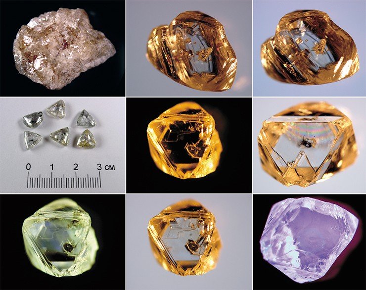
Fig. 10. Morphology of diamonds in the Yakutian diamond province (Photo by A. Pavlushin, IGAiBM SB of RAS, Yakutia).
According to the shape of the horizontal section, kimberlite pipes are divided into simple (round, oval) single-channel, complex (pear-shaped, dumbbell-shaped) two-channel, and very complex (lenticular with swelling or irregular shape) multichannel.
The internal structure of kimberlite pipes is complex, due to the multiphase nature of their formation. Each phase was accompanied by the introduction of a certain variety of rocks (kimberlite breccias, tuff breccias, massive kimberlites, etc.), which differ from each other not only in structural and textural features and material composition, but also in the content of diamonds in them. Usually, diamondiferous rocks of one variety contain a stable amount of diamonds, while their content is distributed extremely unevenly throughout the pipe. And in some places there are areas of kimberlite rocks with substandard diamond content. Kimberlite rocks contain up to 50% of xenoliths of host rocks ranging in size from fractions of a millimeter to chunks and blocks.
Kimberlite dikes and sills rarely form independent deposits and are found in South Africa and Canada (Snap Lake). Kimberlite dikes are steeply dipping bodies ranging from 1 to 5 km long and 1 to 180 m thick. The diamond content in dikes ranges from low to high, and the size of crystals is from medium to large.
The Pipe Mir is one of the most famous kimberlite formations of the Yakutian diamondiferous province. It is a steeply dipping funnel-shaped body (0-600 m), below it is cylindrical. At a depth of about 1000 m, the diatreme sharply narrows and turns into a subvertical kimberlite dike. The diatreme is filled with kimberlite formations formed during the three-phase intrusion of kimberlite magma. According to S. I. Kostrovitsky (Kostrovitsky et al., 2015), kimberlite breccias of the first phase formed the northwestern half of the pipe, and kimberlite breccias of the second phase occupied the southeastern part of the pipe (Fig. 11). The third phase includes dyke-like bodies of porphyric kimberlites. Despite this, the rocks of different phases of introduction differ little from each other. They have the same physical and mechanical properties and the diamond content established during operation with a content of 8.09 carats per ton.
According to the most widespread point of view, kimberlite diamonds crystallized in a static environment at a depth of about 150-250 km at a temperature of about 1200 °C and a pressure of at least 45 GPa. Their parent rocks were hyperbasites (chromium-pyrope dunites, harzburgites, and lherzolites) and mafic rocks (garnet pyroxenites and eclogites). The rise of kimberlite magma took place during the Middle Paleozoic (D3 – C1) tectonic-magmatic activation in an environment of stretching of the earth's crust (Akulov, 2003b).
|
f |
|
e |
|
d |
|
c |
|
b |
|
a |

Fig. 11. Reference samples of kimberlites and xenoliths from various kimberlite pipes of the Yakutian diamondiferous province (after Kostrovitsky et al., 2015 with changes):
a - kimberlite breccia with inclusions of garnet serpentinite (Mir pipe), b - kimberlite breccia (Udachnaya pipe), c - autolithic kimberlite breccia (Nyurbinskaya pipe), d - porphyric kimberlite (Yubileynaya pipe), e, f - eclogite inclusions of diamonds (pipe Mir).
Apparently, the melt was characterized by a high content of the fluid phase. In near-surface conditions (at a depth of about 1–2 km), an explosion occurred due to the separation of volatile components, which contributed to the formation of kimberlite pipes (diatremes). In the process of near-surface crystallization of kimberlite, fine-crystalline aggregates were formed, which make up the bulk of the rocks of the second phase. Due to the action of a powerful fluid flow coming from the bowels through the formed channel of the pipe, autometamorphism took place with the formation of postmagmatic minerals of the third phase. Thus, kimberlite magma could only serve as a “transporter” for the transport of eclogites and diamonds to the Earth's surface (Anand and al., 2004).

It should be noted that in 2001, at a depth of 525 m, open pit mining of diamondiferous kimberlites was suspended. And underground mining began, which continued until 2017, when (according to preliminary data) a water breakthrough occurred at the mine with the formation of mudflow-like mud-like water-mud-stone mass (Arkhipov, 2019). At that time, there were 151 people in the mine. 142 miners were promptly evacuated, and one more was rescued the next day. The search for the eight people remaining in the mine continued for several weeks, but to no avail. Then the search and rescue operations were stopped, and the deposit was suspended (Fig. 12). A detailed investigation showed that the mine was flooded due to the breakthrough of subpermafrost high-mineralized waters. At present, additional exploration of the deep horizons of the pipe continues and options for its further development are being worked out.
In total, more than 4000 kimberlite and lamproite bodies have been identified in the Earth, of which about 500 contain diamonds. The main volume of production is provided by only 15 kimberlite and lamproite diamond deposits (Vaganov et al., 2002). The main criteria for the search for kimberlites in new areas are being actively developed (Protsenko et al., 2018), with great attention being paid to geochemical prospecting for kimberlites in closed areas (Tolstov et al., 2007; Simonenko et al., 2008; Sobolev et al. ., 2018).
Various types of exogenous processes have been affecting various types of diamond-bearing formations for many millions of years, destroying and redeposing them, due to which numerous alluvial diamond deposits have been formed. The richest diamond placers were formed in the Yakutian diamond province (on the Irelyakh river, the "Vodorazdelnye galechniki" placer, placers in the Anabar region on the Ebelyakh, Billyakh, Mayat and other rivers) (Tolstov and Grakhanov, 2014; Tolstov et al., 2019).
4. FROM THE THEORY OF SEARCH TO THE PRACTICE
Modern diamond prospecting is impossible without knowledge of the laws governing the change in diamond-bearing formations in the hypergenesis zone.
4.1. Weathering crust of kimberlites
The formation of the weathering crust of diamondiferous rocks is due to the influence of the environment (water, atmosphere, solar insolation, temperature, life of various organisms, including plants and fungi). Meteoric water and ambient temperature play a major role in weathering. Therefore, the elementary weathering process should be considered in the water-rock interaction system. Practically distilled rain (melt) water is very “aggressive”. Therefore, seeping through the rock, it gradually imbibes (leaches) its mineral components. In this case, an increase in the mineralization of meteoric water occurs, which leads to a weakening of its chemical activity and, accordingly, to attenuation of the leaching processes. An example is the crust of chemical weathering on the shores of the lake Baikal and in the south of the Siberian Platform (Akulov et al., 1992; 1996). In this regard, the winding crust profile is formed from top to bottom. On the surface of such a profile, developed along the granitoids of Khamar-Daban, there is an intensely weathered zone, represented by a member of white kaolinite clays. And its weakly weathered lower part by disintegrated granitoids with spots of iron and manganese hydroxides.
The conditions of their formation and the duration of weathering are important factors contributing to the weathering of diamondiferous rocks. Rocks formed at great depths, where high temperature and pressure prevail, and then brought to the surface, fall into completely different thermodynamic conditions, which leads to their destruction. The age of the kimberlite bodies of the Yakutian diamond province is from 350 to 430 Ma, which indicates the possibility of prolonged weathering. Therefore, it is not surprising that kimberlites are considered the least resistant rocks to weathering processes.
According to N. N. Zinchuk et al. (Zinchuk et al., 1997) and E.A. Shamshina (1979), three zones are distinguished on kimberlites. The upper almost 30-meter zone of strongly weathered kimberlites is represented by grayish-brownish-yellow lumpy clay impregnated with iron hydroxides, in which the structural and textural features of the original rock are not preserved, but a clay mass composed of kaolinite, hydromica and montmorillonite. The middle one which is almost 100-meter hydromica-montmorillonite zone consists of brownish-gray moderately weathered kimberlites, in which relict structures are preserved, but obscured by clayey new formations colored with iron hydroxides. The lower one is composed of slightly altered greenish-gray, strongly cemented rocks, in which the structural and textural features of kimberlites are almost completely preserved (Fig. 13).
|
Montmorillonite |
|
garnets |
|
picroilmenite |
|
Clay fraction |
|
Heavy residue |
|
Power |
|
More |
|
Lower |
|
Middle |
|
Upper |
|
Zone |
|
Minerals composition |
|
Weathering crust lithological profile |

Fig. 13. Lithological and mineralogical section of the weathering crust on one of the kimberlite pipes explored by boreholes (built using the Zinchuk data et al., 1997):
1 - kimberlites, 2 - weakly weathered kimberlites, 3 - strongly weathered kimberlites, 4 - picroilmenite, 5 - leucoxene, 6 - micas and amphiboles, 7 - apatite and epidote, 8 - garnets, 9 - tourmaline, 10 - zircon, 11 - resistant minerals led by diamond, 12 - hydromica, 13 - kaolinite, 14 - montmorillonite.
It is important to note that picroilmenite (up to 40%) and garnets (up to 25%) remain in the composition of the minerals of the heavy fraction of the upper weathering zone. This is due to their resistance to weathering. The stability of minerals is determined by their mechanical strength and chemical resistance. A. A. Kukharenko (1961) suggested using the following scheme to compare the minerals of rocks by their stability in the hypergenesis zone (Table 1).
|
Precipitation, mm |
|
Semi-deserts and deserts |
|
Steppe |
|
Evaporation |
|
Savannah |
|
Tropical forest area |
|
Fallen leaves |
|
Savannah |
|
Tundra |
|
Taiga-podzol zone |
|
Precipitation |

FIg. 14. The classical scheme of the formation of the weathering crust in tectonically inactive areas (according to N. M. Strakhov, 1962):
1 - fresh rock, 2 - grit zone, chemically slightly altered, 3 - hydromica-montmorillonite-beidellite zone, 4 - kaolinite zone, 5 - ocher, aluminum oxides, 6 - clivvy, iron and aluminum oxides.
N. M. Strakhov (1962) constructed a very graphic diagram on the formation of the weathering crust on ancient platforms, on which he showed that it reaches its maximum values on cratons with a humid and hot climate (Fig. 14). These paleoclimatic conditions prevailed on the Siberian platform 350-370 mln. years ago, when, according to the theory of continental drift, the Siberian craton was located in the tropical climatic zone (Khramov, 1991). Thus, if a kimberlite body was located for a long time in the hypergenesis zone, then it turns into a plastic mud-like grayish-brownish-yellow clay, which is a good aquiclude. Usually, the diatreme has a rounded shape in plan, and under the influence of exogenous processes its caldera often turns into a rounded lake.
There is a legend about the discovery of one of the kimberlite pipes in South Africa. It was as if an African had weaved a hut out of branches and coated it with yellow clay, which lies near the hut on the shore of a rounded (caldera) lake. The clay dried up and the sun shone brightly small colorless minerals, which later turned out to be diamonds.
Table 1
|
Moderately stable |
Sustainable |
Very stable |
|
|
Olivine Pyroxene Augite Vesuvian Hornblende Pyrite Cinnabar Melanitis |
Apatite Diopside Ortit Pomegranates (pyrope) Actinolite Tremolite Epidote Zoisite Wolframite Scheelite Ottrelite Axinite Barite Sillimanite |
Anataz Stavrolite Distin Ilmenite (picroilmenite) Hematite Sfen Titanomagnetite Magnetite Monazite Xenotime Perovskite Columbite Cassiterite |
Andalusite Topaz Brookit Leucoxen Chrome spinellide Rutile Tourmaline Gold Platinum Osmous iridium Spinel Zircon Corundum Diamond |
Stability of minerals during weathering (according to A. A.Kukharenko, 1961)
Note: the increasing resistance of minerals to weathering is shown in the columns from top to bottom.
N. A. Shilo (2002) investigated the migration properties of placer-forming minerals and found that due to their properties (increased density, hardness, chemical stability in a wide alkaline-acid range, etc.). They are accumulated in certain deposits, thus determining the concentration of ore matter above the clarke values. He proposed to use the accumulative indicator as a constant of hypergene stability (Chs), which takes into account the hardness of minerals, the energy state of the structure of minerals (H), and their density (r).
Chs = lg (rH)
According to his data, Chs for diamond and zircon is 1.54, for gold - 1.66, and for picro-ilmenite - 1.41. For comparison, quartz, which is one of the most widespread placer minerals, has Chs = 1.26. Quartz serves as a range mark, above which Chs are located for most placer-forming minerals, the amount of which is about 50.
In the process of weathering, stable and partially stable minerals accumulate in the zone of destruction of the original outlet, forming eluvial deposits, represented by accumulations of minerals at the site of destruction. Their further transportation by temporary water flows leads to the formation of spoon placers, and their merging with river flows contributes to the formation of various types of near-drift placers. Coastal placers are formed in the deltas of rivers flowing into large lakes or seas.
It should be noted that the products of the redeposited weathering crust have an “inverted” rhythm with respect to the original weathering crust, which occurs in situ and is easily recognized in the field. At the bottom of such a section, there is usually a fine-grained or pelitic material, and at the top it is coarse-grained, often transformed into conglobreccias. An example is the redeposited products of the Lower Carboniferous weathering crust developed in the southwestern part of the Siberian platform near the Yenisei Ridge. Here, on the eroded surface of Devonian carbonate rocks, kaolin-rich mudstones of the “flint clay” type occur, which transform up the section into quartz sandstones, and then into a thick 25-meter member of conglobreccias.
It should be noted that until 1960, the main production of diamonds fell on dewy deposits. Shiny crystals in river sand and pebble deposits attract the attention of not only geologists. Many diamond-bearing placers have been discovered by children. Thus, the first Ural diamond was found by a serf Pavel Popov in 1829. In South Africa, on the banks of the Orange and Vaal rivers, the children of farmers found the first diamond crystals. Despite the apparent ease of development of alluvial diamond deposits, their miners always face one big drawback i.e. fast areal mining of alluvial deposits. This is due to the fact that the construction of a MPP (a) on the basis of an open field, in the hard-to-reach conditions of Siberia, becomes profitable in the case when there are enough explored reserves and will last for at least 30 years of its operation. This requirement is usually met by the discovery of a primary deposit. In this regard, the primary task of geologists is to find the primary source of diamonds. Thirty years have passed and this task has been solved, which was facilitated by the numerous previously discovered diamond-bearing placers. After 1990, almost 80% of the world's diamond production was produced from primary deposits. At present, in Russia, despite the abundance of dews, more than 95% of diamonds are mined from primary deposits (On state..., 2018).
4.2. Types of diamond placers and tasks of the first stage of their search
V. P. Afanasyev and colleagues (Afanasyev et al., 1984, 2008, 2010) carried out an experimental study of the abrasive resistance of diamond and its companions - pyrope, picroilmenite, olivine, apatite, as well as fragments of diamondiferous kimberlites. The following series of their decreasing abrasion resistance was obtained: pyrope-picroilmenite-apatite-olivine-kimberlite. The diamond practically did not change during the experiment. Fragments of kimberlite turned out to be quite stable, and their relics survived almost until the end of the experiment, while all satellite minerals acquired the form of wear. Pyrope, olivine and apatite are characterized by oval wear type. Picroilmenite forms tablets with hexagonal outlines typical of ancient halos.
The ratio of the abrasive resistance of pyrope and picroilmenite showed that in coastal marine conditions, picroilmenite is completely abraded, while rounded pyrope and diamonds are preserved. In this case, a stable diamond-pyrope mineralogical association is formed with an insignificant admixture of chrome spinellides, which are smaller in size than pyropes and diamonds. Mechanical changes were noted in diamond crystals due to their chipping, abrasion of edges and tops (Afanasyev, 1989).
The main features of schlichineralogical analysis indicate that clastic material, or as it is called terrigenous material from erosion of kimberlite pipes, is found only in those watercourses that drain them, while the distribution of minerals of diamond satellite dikes is linear (scattering flux).
According to V. I. Vaganov and his colleagues (Vaganov et al., 2002), placer diamonds make up a small (about 10%) part of the world production of natural the importance of placer deposits. Among the known industrial alluvial diamond deposits, the following main genetic types stand out: alluvial, deluvial-proluvial (including karst depressions), and coastal-marine. In Yakutia, deluvial and alluvial (terrace and valley) diamond deposits are widely developed. They were formed in the process of long-term destruction and redeposition of bedrock diamond-bearing kimberlite rocks. Among the valley placers, there are trailing, alluvial and channel ones.
The second region in terms of the size of exploited diamond-bearing placers is located in the Northern Urals. The Ural placers were formed as a result of the destruction of diamond-bearing tuffisites.
The Arkhangelsk Oblast is the third alluvial diamondiferous area, which was discovered relatively recently and is located within the primary deposits of diamondiferous kimberlites.
Let us note the main features of these processes without dwelling on the characteristics of the transport mechanisms and the concentration of placer-forming minerals in various environments, which are discussed in detail in the following works: A. A. Kukharenko (1961), B. I. Prokopchuk (1979), B. N. Sokolov (1982), S. S. Voskresensky (1985), Yu. A. Burmin (1988), V. E. Minorin (2001), N. A. Shilo (2002), A.A. Kremenetsky with colleagues (2006), S. A. Grakhanov with colleagues (2007), N. G. Patyk-Kara (2008), O. K. Kilizhekov with colleagues (2017).
The main mechanism for the formation of placers is their separation by size (mass), density and chemical stability. The last two indicators are taken into account by the constant of hypergene stability, which makes it possible to compare the migration ability of minerals of equal, mainly sandy dimension. It is noted that the same mineral, depending on the granulometric class in which it is located, has a different migration ability. The migration ability of diamonds is also influenced by the shape of the crystals and hydrophobicity. Two tendencies on the way of their migration along with indicator minerals or minerals-satellites from the primary source are well recognized: on the one hand, gradual destruction, abrasion and dispersal, and on the other hand, this is the removal of unstable minerals along the path of their long-distance transport and the formation of new ones. stable terrigenous-mineralogical associations. Thanks to this, the concept of the genetic category of the placers is autochthonous and allochthonous, as well as local and regional.
According to the degree of their remoteness from the primary sources of diamonds, they are subdivided into placers of near drift and long-range transport (redeposited). The first group includes eluvial-deluvial and alluvial placers. They are characterized by a high concentration of diamonds, and in the areas of karst distribution they give large and sometimes unique deposits.Вторая группа россыпей алмазов представлена россыпями, удаленными от источника питания на десятки — сотни километров; среди них преобладают озерно-морские (россыпи конечных водоемов), аллювиальные и ледниковые.
G. Kh. Feinstein (1977) divided secondary sedimentary diamond collectors into 3 groups according to the distance of transfer of fragmentary material into 3 groups: 1) the nearest transport (0-5 km); 2) short-range transport (5-30 km) and 3) long-range transport (more than 30 km). He writes that the distance of up to 5 km from the power source for sedimentary reservoirs of the nearest transfer was established using the example of modern spoon and Rhaetian-Lias placers of diamonds in Yakutia, as well as placers of titanium ores (ilmenite placers).
According to S. A. Grakhanov and V. I. Koptil (Grakhanov and Koptil, 2003), the transfer of diamonds downstream or along the coast can be traced for many hundreds of kilometers. For example, they managed to trace a halo of diamonds coming from the Pipe Mir along the Irelyakh-Mal water system, Botuobia - Vilyui at a distance of more than 500 km.
These two types of placers differ significantly not only in the mechanism of concentration of useful minerals, but also in terms of feeding the placer-forming process.
So, near-drift placers represent a local result, often of a relative concentration along the path of the closest scattering of diamonds. These are scattering streams or mechanical halos of a local root source.
Long-range transfer placers are formed without a visible connection with a specific primary source as a result of prolonged, usually multiple redeposition of clastic material, often through intermediate reservoirs, accompanied by its perfect separation. Long-range transport placers are well preserved in the composition of fossil alluvial formations.
All currently known diamondiferous placers, according to one or another feature (morphological, genetic, morphogenetic, dynamic, etc.), are divided into a number of types of placers. In our opinion, the most important feature that allows one to clearly distinguish diamond placers in the field is the genetic one. In nature, there are many genetic types of terrigenous deposits, to which diamond-bearing placers are confined. Thus, the genetic types of terrigenous formations containing diamonds also determine the genetic type of diamondiferous placers. Among them, there are proluvial, colluvial, eluvial-deluvial, alluvial, lacustrine, coastal-marine and other less significant genetic types.

Fig. 15. The sequence of exploration work on alluvial gold-bearing and diamond-bearing placers (according to A. S. Ageikin et al., 1982 as amended):
Stage: a - general search, b - preliminary reconnaissance, c - detailed reconnaissance;
1 - alluvial deposits, 2 - bedding rocks, 3 - edge of the erosional-accumulative terrain, 4 - exploratory lines, 5 - areas with established industrial gold content.
It should be noted that in terms of diamond reserves in the world among the Cenozoic placers (without Russia), the first place is occupied by deluvial-karst placers (more than 60% of reserves), the second place belongs to alluvial placers, and the third place belongs to various types of coastal-marine placers and open shelf (Dictionary on Geology ..., 1985).
Among the main tasks that have to be solved at the first stage of the search for diamonds, first of all, it is necessary to find out in the studied deposits at least single grains of heavy diamond concentrates (HDC): pyropes, olivines, moissanite, chrome diopsides, picroilmenites, chromites, etc. Solution of this task is possible only with knowledge of the main laws governing the formation of various genetic types of diamond placers, on the basis of which it is necessary to make a local forecast of the most favorable potentially diamondiferous areas (geological bodies) and carry out their preliminary sampling.
If HDC is found, the studied deposits are subjected to detailed sampling in order to establish the length, width and thickness of the open placer, as well as the average diamond content in them. It is interesting to note that during the open development of the Pipe Mir, it was experimentally established that one ton of kimberlite contains about 20 kg of indicator minerals, including more than five kilograms of chromium-containing pyrope. Such kimberlite pipes form an HDC plume near them, which made it possible to detect it. A geologist walking along the river channel in the footsteps of the HDC will certainly come to the kimberlite pipe.
The sequence of exploration work on alluvial placers is conventionally shown in Fig. 15.
It should be emphasized that diamond in placer samples is extremely rare, since the volume of one such sample is only 10-15 liters of sand-and-shingle or argillo-arenaceous material, and not every cubic meter of diamond-bearing deposits or weathered kimberlite contains at least one crystal diamond.
This means that it is practically impossible to search for both primary and alluvial diamond deposits by the appearance of crystals of this mineral in concentrates. For these purposes, small-volume sampling is carried out or the main attention is focused on heavy diamond concentrates: blood-red pyrope, pitch-black picroilmenite and emerald-green chrome diopside (Fig. 16).
Searches for kimberlite pipes using schlich sampling along the scattering halos of diamond satellite minerals are widely known in the geological literature (Zinchuk et al., 2004) and, in principle, do not present any particular difficulties. They are very vividly and colorfully described and demonstrated in photographs in the monograph by A.M. Khmelkov (2008).

Fig. 16. Heavy diamond concentrates: blood-red pyrope from the Mir pipe and emerald-green chrome diopside from the Inagli massif on Aldan (photo by A. A. Yevseyev).
Starting from the earliest prospecting works for diamonds, it was found that rivers, streams and channels are the most favorable for schlich sampling (Burov, 1957). Sampling is usually carried out at intervals of about 1 km and in the direction from the mouth to the source of the river. After washing the schlich sample, the geologist is obliged to carefully study it in order to detect blood-red pyropes or other visually recognizable satellite dikes of diamonds. As he moves along the river to its upper reaches, the researcher finds himself in the province of feeding the river channel with terrigenous material. If the amount of pyrope in the concentrates increases and their size increases, then it is on the right track to the kimberlite pipe. When the schlichs are washed out above the area of the removal of terrigenous components from the kimberlite body, pyropes and other satellite dikes of diamonds abruptly disappear. In this case, it is necessary to study in detail the places of schlich sampling of the valley slopes or tributaries of the river located between the last “empty” sample and the penultimate one with pyropes. Thus, it is possible to find both primary (kimberlite) bodies and ancient intermediate diamond collectors. The ultimate goal of prospecting is to identify an industrial primary or placer diamond deposit.
4.3. Criteria and signs of diamond-bearing placers
The criteria and features of diamondiferous placers make it possible to judge the prospects of this or that territory for the discovery of placer diamondiferousness. The basis for their identification is a systematic analysis of the main prerequisites for the formation of diamond placers.
To date, it has been established that the most important criteria indicating that the territory is promising for prospecting for alluvial diamonds are: 1) the presence of primary sources of diamonds in the area under study; 2) the presence in the section of sedimentary strata of stratigraphic horizons, the time of formation of which corresponds to the erosion and denudation of the primary diamond sources (epochs of placer formation); 3) paleogeographic conditions for the formation of potentially diamondiferous deposits (type of sedimentation basin or weathering crust and products of its redeposition); 4) sources of nutrition for sedimentary paleobasins, as well as the type and conditions of transportation of terrigenous material (features of the formation, transformation and conservation of placers).
Along with the search criteria, uniting consistent, statistically stable indicators, a huge role is played by less stable indicators - signs of diamond-bearing placers. Prospecting signs of diamond placers include: 1) the presence of an erosion-denudation cut of the primary source (kimberlite pipe or buried placer) of diamonds in the study area; 2) finds of fragments of bedrocks (kimberlites) in terrigenous deposits; 3) the presence of heavy diamond concentrates in rudaceous fractions; 4) information about the finds of diamonds among the alluvial deposits of the study area.
In addition to the listed criteria and features, diamond-bearing placers have a number of characteristic features that determined their formation. These features are based, firstly on the behavior of diamonds in the process of transfer and sedimentation, as well as on data on the structure and composition of the enclosing and underlying rocks. These characteristic features include the following: 1) confinement of diamond-bearing placers to rudaceous deposits (granulometric factor); 2) close connection of the most diamond-enriched terrigenous material with near-bedrock layers (factor of high specific gravity); 3) the presence of enriched zones among the redeposited products of the weathering crust (a factor of high diamond stability); 4) the ability of diamonds to form placers of long-range drift and multiple redeposition, due to their high hardness and hydrophobicity (physical and mechanical factor); 5) geomorphological features of the site, which direct the formation of the placer, including control of the basis of erosion, areas of avalanche discharge of terrigenous material (geomorphological factor).
5. TYPES OF TESTING WORKS IN SEARCHING FOR DIAMONDS
No researcher will begin the study of the diamond content of an unfamiliar river by studying the roundness of pebbles or their granulometry, as rightly pointed out by one of the experienced diamond geologists, B.M. Sokolov (1982). First of all, he will begin by testing it for diamonds and their paragenetic satellite dikes.
Depending on the purpose, an ordinary, special technical, technological and operational sampling of diamond-bearing placers is distinguished. In this book, we will only deal with the issues of ordinary sampling, which is carried out at all stages of geological exploration and includes a system of operations that ensure the study of the mineral composition of the heavy fraction of terrigenous sediments in order to identify and determine among them the content of diamonds or their heavy concentrate (HC). The data obtained in the course of routine sampling are the initial material for delineating and calculating the reserves of the identified placer. Both pits and ditches are tested vertically along the walls. The volume of each sample is one placer watersink (10 l). In the event that it is cemented, it is preliminarily disintegrated mechanically in a mortar (it is desirable to obtain a crumbling without disturbing the structure of mineral grains). To do this, the cemented fragments are poured with water if the cement is clayey or 5% HCl if it is carbonate. When taking a bulk sample (small-volume or large-volume), it contains all the material obtained when driving a dug hole. Bulk samples taken from trenches or ditches are usually 10-40 m (or more) sections for the entire thickness of the potentially diamondiferous formation.
When testing wells, the core is divided along the long axis and half or a quarter of it enters the sample. The entire core is used as a sample out of the most interesting intervals of the well, which allows obtaining more reliable information.
Thus, at present, four types of sampling work are distinguished as part of ordinary sampling: schlich, crushing, drilling (core and sludge) and gross (small-volume and large-volume).
Slice sampling is the most common type of sampling in prospecting for diamond deposits. Thanks to the schlich sampling, the scattering halos of the HDC are established and the paths of the drift of the terrigenous material are determined. To increase the reliability of the study, sometimes two trays of terrigenous material (20 l) are washed.
Sampling for crushing to determine the mineral composition of ancient rocks and the detection of HDC is carried out from near-bed areas. The sample must include material from the “scuff” (from a depth of up to 20 cm from the surface of the raft). For the manufacture of crushed conglomerates, cement is selected in the places of its greatest accumulation. After grinding, the sample is poured into a placer watersink and sieved.
The results of the analysis of crushed samples, as well as other information on prospecting and sampling, are plotted on the prospecting map (plan).
Small drill rigs of the UPB-25 type are used to open a relatively shallow-lying bedrock, as well as to study loose productive sediments.
Cable-tool drill is usually used to open and sample sand-and-shingle deposits of terraces and floodplains under a thick layer of fine-grained formations. Drilling is carried out along profiles across the valleys from bedrock on one side to bedrock on the other. Sampling should preferably be done with a Canadian spoon.
Small-volume samples are taken in areas most enriched in paragenetic satellite dikes of diamonds. Such areas are outlined in the course of schlich sampling. The volume of samples varies from 0.5 m3 to 1.5 m3, depending on the nature of the tested deposits and the degree of their diamond content. Samples are taken using pits, ditches, sometimes using a bulldozer or excavator. In connection with the discovery of new sources of diamonds - lamproites, new recommendations for small-volume sampling appeared (Temporary methodological ..., 1988). In particular, it is indicated that small-volume sampling in the search for lamproites and diamond-bearing placers developed on them, due to the fact that the average background concentrations of
Suppose that in the course of prospecting for diamonds, one cubic meter of sand and gravel deposits is washed. How much should the resulting concentrate weigh?
Based on the experience of geological exploration, it is assumed that one cubic meter of sand and gravel deposits weighs 1.5 tons, and the mass of the heavy fraction minerals contained in it (minerals with a density of more than 2.9 g/cm3) averages 0.5-3 kg. For every ton of small-volume samples washed in the field, we have from 0.3 to 2 kg of concentrate. Due to the fact that the concentrate is washed to a gray concentrate, its weight is always much higher and reaches 3 kg or more. G. F. Feinstein (Feinstein, Lebed, 1988) wrote that when the first diamond-bearing pipes were opened, from each cubic meter of “sands” supplied to beneficiation, from 5 to 50 liters of concentrate was obtained, which indicates a large underwash of the tested sediments.
It is important to emphasize that in the course of obtaining a concentrate in the field, all mineral grains must be washed from clay smears and clay “aggregates” (pellets). Washing is usually carried out immediately after unloading the shaker (before depositing) in a sieve, with holes smaller than the size of the washed fraction, in running water. Washing goes on until the release of clay "turbidity" and light gray minerals of the light fraction stops.
Large-volume sampling is carried out to confirm the presence of diamonds found in small-volume sampling and to determine the diamond grade. According to G. Kh. Feinstein (1968), this sampling is especially necessary where the alluvium of streams draining the development fields of diamond-bearing and pyro-bearing deposits is devoid of diamond satellite dikes. And in the adjacent areas, river sediments contain large diamonds with an average weight of more than 10-15 mg. The frequency of detecting such diamonds is several times less than in placers with small diamonds, and therefore the probability of finding at least one such crystal in a small-volume sample is small.
The required sample volume for large-scale sampling is usually calculated using the Burov-Volorovich formulaSuppose that in the course of prospecting for diamonds, one cubic meter of sand and gravel deposits is washed. How much should the resulting concentrate weigh?
Based on the experience of geological exploration, it is assumed that one cubic meter of sand and gravel deposits weighs 1.5 tons, and the mass of the heavy fraction minerals contained in it (minerals with a density of more than 2.9 g/cm3) averages 0.5-3 kg. For every ton of small-volume samples washed in the field, we have from 0.3 to 2 kg of concentrate. Due to the fact that the concentrate is washed to a gray concentrate, its weight is always much higher and reaches 3 kg or more. G. F. Feinstein (Feinstein, Lebed, 1988) wrote that when the first diamond-bearing pipes were opened, from each cubic meter of “sands” supplied to beneficiation, from 5 to 50 liters of concentrate was obtained, which indicates a large underwash of the tested sediments.
It is important to emphasize that in the course of obtaining a concentrate in the field, all mineral grains must be washed from clay smears and clay “aggregates” (pellets). Washing is usually carried out immediately after unloading the shaker (before depositing) in a sieve, with holes smaller than the size of the washed fraction, in running water. Washing goes on until the release of clay "turbidity" and light gray minerals of the light fraction stops.
Large-volume sampling is carried out to confirm the presence of diamonds found in small-volume sampling and to determine the diamond grade. According to G. Kh. Feinstein (1968), this sampling is especially necessary where the alluvium of streams draining the development fields of diamond-bearing and pyro-bearing deposits is devoid of diamond satellite dikes. And in the adjacent areas, river sediments contain large diamonds with an average weight of more than 10-15 mg. The frequency of detecting such diamonds is several times less than in placers with small diamonds, and therefore the probability of finding at least one such crystal in a small-volume sample is small.
The required sample volume for large-scale sampling is usually calculated using the Burov-Volorovich formula
, where
P is the volume of the most representative sample; A - average weight of diamonds in placers adjacent to the prospecting area; С - average diamond content in placers adjacent to the prospecting area; K is the reliability factor, conventionally taken equal to 2.
What should be the minimum bulk sample volume? Let's conditionally establish that the average weight of diamonds in the placer is 100 mg (so as not to miss a diamond with a size of 0.5 ct), and the average minimum (borne) content in the placer is 0.1 ct/m (20 mg/m3). Substituting the given data into the above formula, we obtain
To enrich the analyzed material and obtain the necessary concentrate, a primitive field processing plant is being built. Its construction and operation is carried out by a special enrichment detachment, provided with an excavator or bulldozer and an all-terrain vehicle for transporting the test material, the volume of which varies from several tens to several thousand cubic meters. For example, in 1954, the party No. 47 of the Oryol expedition from alluvial deposits of one of the sections of the Chuny river (south of the Siberian platform) 2112 m3 of sands were sampled. As a result of their enrichment, 16 diamond crystals with a total weight of 113.2 mg were recovered. It is easy to calculate that the average grade in this placer is 0.00027 carats/m3. Is it a lot or a little? It is known that in foreign practice, primary deposits are exploited with a diamond content usually from 0.5 to 5-10 carats/t, and placer deposits with a diamond content of about 0.1-0.3 carats/m3 and higher (Berlinsky, 1988). Thus, this placer is characterized by a very low or poor diamond content.
Table 2
Classification of diamond placer deposits (Placers of diamonds ..., 2007)
|
Parameter |
Size, level |
|||
|
Size, mln ct |
Unique Over 20.0 |
Large 5-20 |
Average 1-5 |
Small Up to 1.0 |
|
Diamond content, ct/m3 |
Unique Over 5.0 |
High 1-5 |
Average 0.5-1.0 |
Low lower 0.5 |
|
Price, USD/ct |
Unique Over 100.0 |
High 50-100 |
Average 30-50 |
Low Up to 30.0 |
S. A. Grakhanov et al. (Placers of diamonds ..., 2007) proposed the following variant of the classification of alluvial diamond deposits (Table 2). In this regard, it should be noted that the main reserves of placer diamonds in Russia are concentrated in Western Yakutia and are distributed over the following regions: Anabarsky (64.2%), Sredne-Markhinsky (13.8%), Malo-Botuobinsky (12.3%), Prilensky ( 4.6%), Muno-Tyungsky (2.3%) and Daldyno-Alakitsky (1.4%). The missing interest belongs to another region of Russia - the Perm Oblast (1.4%). It should be noted that the richest place is the river basin Ebelyakh (Anabar region), where 52.3% of all Russian reserves of placer diamonds are concentrated (Placer diamonds ..., 2007).
An important condition for prospecting for diamond-bearing placers is the production of high-quality diamond-bearing concentrates, as well as their thorough analysis at stationary installations, excluding the possibility of contamination with diamonds from other samples. It is noted that in Western Australia, mass finds of diamonds in lamproites began only after a new processing plant was commissioned in August 1978 (Temporary methodical ..., 1988).
5.1. Equipment: tools and materials for field work
When carrying out expeditionary work, an ordinary geologist must have: a geological hammer, a mountain compass, a set of topographic maps, a field book, pencils, a geological satchel, a knife, a tape measure, 5% hydrochloric acid, labels and bags for samples. A diamond geologist will need a whole range of equipment and tools, which includes: 1) a set of sieves (roar), which is often mounted in the form of a single, easily movable mechanism - a shaker; 2) marching flush lock; 3) a jigging plant of the Ji-gi type or a portable screw separator; 4) wooden or plastic sizing trays; 5) entrenching tool: a set of shovels (pick and bayonet), pick, crowbar, wedge, chisel, ax, chainsaw; 6) a cast-iron mortar (2-3 l volume) for the manufacture of prototypes from cemented rocks; 7) tarpaulin (awning) of dimensions 2x3 m; 8) a awning and everything you need for sleeping and cooking.
In addition to base maps, you must have: 1) 2-3 copies of field maps for applying data (actual material); 2) satellite dikes navigation system and portable position control system (GPS) for binding precise geographic coordinates and altitude data; 3) laptop for registering important objects and data; 4) digital camera and video camera for shooting each tested area and documenting mine workings (pits, ditches); 5) an aircraft - a quadrocopter or drone for aerial survey of the research area; 6) documents for carrying out geological exploration works; 7) a ruler with micron divisions for measuring HDC mineral grains and diamond crystals.
Personal protective equipment plays an important role: hunting knife and rifle; mosquito nets and insect repellents; sun hat, gloves and mountain boots for outcrop work; portable generator or small-sized power plant; gas cylinders for cooking; money to buy the necessary things, as well as a first-aid kit.
The data collection methodology is further subdivided into three categories, each of which represents a collection technique: observation, diary, photography, and video filming. In the diary, each field route is recorded by the date of its conduct, the composition of the search group according to surname, the purpose of the route and the exact binding of each described observation point. All this will serve as the basis for reporting on the results of the exploration work. The researcher records measurements and observations related to specific outcrops, their general characteristics. It is very important that all documentation is completed at the outcrop or mine working itself, and not carried out after returning to the camp.
Geological observations include a description of the composition of the bedrock, geological features of occurrence and types of overlying deposits. A preliminary assessment of the environmental conditions in the area of the future mine and in the adjacent territory should be carried out.
When carrying out work in areas with identified diamond content, drilling crews with self-propelled drilling rigs are involved, and when tracing paleovalleys and preliminary contouring of ore bodies - geophysical research methods (VES survey, magnetic survey, etc.).
Since the extensive literature is devoted to drilling and geophysical research methods, and the main attention will be paid to jigging devices below, here we will focus only on tools for driving mine workings manually and sampling for the purpose of flushing them on a jig plant. Bayonet and pick-up shovels are used as such tools, and when working with cemented deposits - picks and metal wedges (Fig. 17). In the process of driving workings, workers (miners) often use home-made, improved varieties of shovels: bayonet - tunneling and collecting - shovel (loading). The choice of a shovel with a particular width of the working blade should be made on the basis of the following rule: the higher the specific gravity of the rock, the smaller the blade of the shovel should be. This is because it has been established in practice that the least fatigue of the worker and higher labor productivity are achieved when placed on shovel no more than 8-9 kg of rock.
Often, the rocks of the block, which are of primary interest in diamond prospecting, turn out to be strongly cemented or represent a monolithic conglomerate. In such cases, a pick, crowbar, chisel and wedges are used. A pick can be one-sided (one-blade), two-sided and a pick-hoe (see fig. 17). The peculiarity of the latter is that instead of a point, it ends with a blade. In most cases, in double-sided tools, one blade has a tip, like a regular pick, and the other has a blade, like a pick-hoe.
Usually, experienced miners sharpen, harden and beat off tools before starting tunneling work. Their hardening is carried out by heating over a fire to a red-hot color and shaping with a hammer, and then cooled in cold water with tempering to a purple color.
It is no coincidence that we dwelt in such detail on mining tools, since all geological exploration work is based on mine workings, the competent implementation of which can greatly facilitate the work of miners, save time or conduct mining work not where it is good to “dig”, but there, where it is truly necessary.
The search for paleo placer deposits is accompanied by a whole complex of lithological studies. First of all, natural outcrops of rocks are comprehensively studied. In their absence, excavation of pits, ditches or clearing is carried out. Description of sedimentary rocks along the section is carried out from bottom to top, in the following sequence:
- Granulometric type (sandstones, mudstones, etc.).
- Form of occurrence (formation, lens, interlayer, etc.).
- Power.
- Structural and textural features.
- Color.
- Material composition (roundness, sorting, field mineralogy).
- Genetic traits (wave-break marks, traces of turbidity and underwater landslides, drying cracks, nodules, etc.).
- Type of cement (clay, carbonate, quartz, ferruginous, etc.), the nature of cementation (basal, pore, contact, etc.).
- Paleontological remains (flora, fauna, ichthyofauna, etc.).
- Contact (blurry, clear, gradual, unclear).
- Cyclicity and rhythm (rhythms, cycles, mesocycles, macrocycles).
- Sampling for granulometric (30 g), petrographic (thin section, 30 g), palinological (150 g) and clay (100 g) analyzes.
|
h |
|
g |
|
f |
|
e |
|
d |
|
c |
|
b |
|
a |

Fig. 17. Tools for driving mine workings manually (according to A. R. Sushon, 1976):
shovels: a - spade, b - tunneling, in - loading (scoop);
picks: d - one-sided (straight and oblique), d - double-sided;
wedges: e - square, g - rectangular, and h - round.
As a result, the bag with the selected sample should weigh 300-350 g. Thus, the sample volume for all types of lithological analyzes should be equal to the volume of a 200-gram glass. Samples of rocks for all types of analyzes are taken from each type of rocks or lithological variety, and in homogeneous strata - every 5 m. It should be remembered that samples are taken for chemical analysis only from the weathering crust, as well as from various chemogenic formations (10 g each of them). The chemical composition of the fine-pellet fraction is performed after its laboratory elutriation and drying (2-3 g is required for analysis). Particular attention is paid to sampling for crushing with the purpose of detecting HDC. Its volume is usually 15-20 kg.
The rocks that make up the ancient sedimentary bodies enriched with diamonds or their satellite dikes are usually called intermediate reservoirs, although oil geologists are very indignant about this and demand to call reservoirs only those rocks that contain oil fluids and ensure their mobility. Nevertheless, the term intermediate reservoirs is deeply rooted and is widely used by diamond geologists.
Intermediate reservoirs are usually consolidated and overlain by “waste” rock strata. Consequently, all diamondiferous paleoros are intermediate collectors of diamonds, but not all intermediate collectors are paleoros.
The most expedient search for paleo placer deposits in places where intermediate diamond collectors emerge on the day surface. Such places are usually located along the outskirts of such large structures as the ancient mainland of Angarida and the Anabar anteclise on it. If shallowly buried intermediate diamond collectors are found within a promising area, it is most reasonable to drill shallow wells that open the intermediate collector along a sparse grid over the entire area. Based on the data obtained during drilling, a plan of the investigated area is built taking into account the location of the found diamonds and their satellite dikes. Based on this, further, more detailed searches for paleo-placer deposits are being carried out, but already proceeding from the analysis of the regularities of the formation of an intermediate reservoir, its enclosing sediments and the supposed locations of their primary sources.
6. METHOD OF OBTAINING DIAMOND-CONTAINING CONCENTRATES IN FIELD CONDITIONS
The main purpose of any type of sampling in the search for diamonds, gold or other placer-forming minerals is to obtain a concentrate by dividing the initial sample into light and heavy fractions, followed by pouring the light fraction into a dump. The concentrate is a schlich consisting of heavy fraction minerals, which may include HDC, diamonds, gold, platinum and other valuable minerals and their aggregates. During operational work, mineralogists examine concentrates under a binocular microscope in the field, but this is usually done in the winter during the office period. Prospector trays, various depositing devices or mechanical depositing machines are used to obtain concentrates.
Fig. 18. Korean-style prospectors are made from poplar or aspen: small, medium, giant, and supergiant.

|
small |
|
Supergiant Giant
|
|
Middle |
6.1. Elementary Jigging Basics
Jigging is a method of separating mineral grains of the investigated sediments by specific gravity. In the field, jigging is always done in an aquatic environment. As a result of repeated shaking and swaying, the terrigenous material is repeatedly weighed and loosened, and then sank to the bottom and compacted. In this case, the heaviest fraction is located in the lower part of the sand mixture, and the light fraction (tails) settles on its surface. Then it is gradually washed out by a scraper during water washing. All jigging machines, cradles and butars are based on the same principle.

Fig. 19. Prospector tray with grooves on the flush plane and a paddle for removing coarse-fragmented material, and crushing clay pellets during screening.
The specific gravity of the heavy fraction is usually more than 3.2 g/cm3, and the light fraction is 2.7 g / cm3. The more intermediate fraction in the material (specific gravity 2.7 - 3.2 g/cm3), the worse the jigging occurs, and the resulting concentrate is not black (dark), but gray or light gray. Sometimes geologists deliberately force the scrappers to wash up to gray concentrate in order to preserve the heavy fraction as much as possible. This is very negatively perceived by mineralogists, who have to carry out additional work to remove minerals of the light fraction in laboratory conditions using bromoform.
One of the simplest methods of depositing is washing the sample in a prospector's tray (Fig. 18). Before washing, the tested material is subjected to wet screening on a sieve, the mesh size of which is adopted by the researcher himself (from 5 to 2 mm), depending on the dimension of the studied components. Screening is usually carried out in shallow water, where a sieve is placed on a tray immersed in water, into which the material to be tested is poured with shovels. After screening in water (until the tray is full), the oversized sample remains are abruptly turned over and the gravel-pebble material is carefully poured onto the sandy bank. Here, they scan the washed pebbles and gravel in order to visually search for large diamonds and fragments of diamond-bearing rocks. The concentrate is washed off from the material that turned out to be in the tray. The finishing of the concentrate must be completed when the concentrate acquires a dark gray color. This careful flushing (leaving a small amount of light fraction minerals) is necessary to avoid loss of HDC.
|
h |
|
g |
|
f |
|
e |
|
d |
|
c |
|
b |
|
a |

Fig. 20. Prospector trays made of plastic and metal:
a - Australian (gateway in a tray) Hillier's plastic tray (Turbopan), b - black plastic (Estwing BP-16), c - green plastic (Garret Gravity Trap), d - rectangular plastic green trap (LeTrap), e - combined, multifunctional with catching grooves and a micro-lock at the bottom (Trinity Bowl), e - steel grooved with three retaining grooves (Estwing), g - prospector's set, h - hexagonal plastic blue (JOBE Hex). The hexagonal shape contains two faces of deep grooves (6 on each) for primary processing of the material, two faces of sixteen secondary grooves for main processing and two sides with a textured surface for finishing washing.
The washing of the concentrate samples and the production of the diamond-bearing concentrate is carried out in ordinary Korean-type prospector trays (see Fig. 18). An experienced washer can wash from 20 to 50 trays per shift, i.e. 0.2-0.5 m3 of rock. The loss during washing in such a tray reaches 15% or more (Crater, 1940). In order to reduce the loss of useful components, trays with a corrugated surface of the flush plane are used (Fig. 19). For the first time, a tray with a corrugated surface was developed and applied by M. V. Solodyankin. Laboratory tests have shown that the Solodyankin tray surpasses even the Wilfley jigging table in terms of the quality of extraction of heavy fraction minerals (Crater, 1940).
The reader should be reminded that already at 80% recovery of the heavy fraction into concentrate, almost all diamonds are in concentrate (Romanchikov, 1983). This is explained by the high penetrating ability of diamonds down to the sieve of the jigging chamber due to their high specific gravity and low coefficient of friction for most minerals and rocks (high migration ability). Therefore, it is permissible to operate jigging devices and machines, on which the yield of the heavy fraction is at least 80%. Manufacturers currently offer a variety of plastic and metal trays (Figure 20).

Fig. 21. Portable foldable airlock (Royal backpack). Mini-sluice four-kilogram installation: general view in assembled and disassembled state.
6.2. Obtaining concentrates using jigging devices
At the heart of all modern jigging devices is the sluice operation scheme, copied from the principle of the elementary operation of a bootara, cradle or American rocker.
The sluice is a simple yet effective setup that can handle much more material than manual flushing in a sludge trough. Unlike the bootar, cradle and American rocker, which have wooden structures, modern portable sluices are made of aluminum or stainless steel and installed at an angle of 5-7° directly on the shallow but running bottom of the river (Fig. 21). The streams of water, passing through a sluice hidden under the water, wash the poured alluvial material. They are used for gravitational enrichment by separating mineral grains from the pulp of a large specific gravity in vortex flows and obtaining a concentrate as part of an enriched complex of heavy fraction minerals. The principle of operation of the sluice is based on the separation of two flows of pulp movement: upper and lower. Downstream speed, slower and considering upstream pressure, heavy mineral grains sink into PVC mats. Corrugated rubber carpet are often used as mats. Under the influence of a turbulent water flow, heavy mineral grains are deposited (retained) on the corrugations of rubber mats. Minerals of the light fraction are carried away by water flows outside the sluice.

Fig. 22. American rocker (dimensions are given in millimeters) (after V. M. Kreiter, 1940).
Vashgerd is one of the oldest and simplest devices for the enrichment of sands, it consists of a receiving hopper with a bang (5 mm sieve) and a sluice (with a special bedding), barred by slats. Water is supplied to the cradle through a special chute, but most of all it is simply poured onto the sand and gravel mixture that is in the receiving hopper from a bucket. Having passed through the bang, the water-sandy-clay mixture flows down the plane of the cradle, taking away lighter particles with it. In the process of rock movement, heavy concentrate accumulates at the slats on the litter, from where it is carefully collected after washing the sample. To facilitate the collection of the concentrate, the bottom of the cradle is covered with a cloth, which, after washing, is removed and the concentrate is collected from it. Sometimes, instead of cloth, the bottom is covered with felt or straw boards. Jigging operations on it are usually carried out by three workers. The washing capacity is from 3 to 6 m3 per shift, depending on the washability (clay content) of the rock. Loss during flushing usually does not exceed 10% (Zakharova, 1974). If diamonds and their satellite dikes are confined to small granulometric classes, their washout with light fraction minerals can reach 30-50%.
When developing placers of gold, diamonds and other valuable minerals, an improved version of a cradle is used. A hydrosherd, the work of which is based on the effect of a pressure jet from a hydraulic monitor on loose deposits. The apparatus consists of a disintegrator-classifying part and a hydromonitor (Methods of selection ..., 1984).
Butara is an enrichment plant, which, in contrast to the cradle, is equipped with many locks of different sizes, which generally resemble a ladder. A cloth is laid on the bottom of the butar, which creates a wavy surface that helps to trap heavy minerals less than 0.25 mm in size. In addition, the butara is equipped with a device for rock disintegration and cleaning of minerals from clay additives. This device is located immediately below the screen (5 mm sieve) near the hopper.
The American rocker has a device for swinging (shaking) the test material from side to side during flushing (Fig. 22) in contrast to the bootar and the cradle. In it, the system of locks is simplified to a minimum, and its length reaches 1.7 m. Rokker, like butara, is equipped with a device for disintegration of adhered minerals, which contributes to their better washing from clay material. Due to the presence of a swinging device (rounded unstable base), the rocker has a higher productivity and quality of concentrate washing than the above-described jigging devices.
A very interesting simple and fast way of enriching the initial small-volume sample was proposed by V. D. Skulsky (Feinstein, Lebed, 1988). A sieve with 1 mm holes is tied to a tripod made of poles. A sand-pebble mixture is poured onto a rhythmically swinging sieve and portion by portion is washed with water from a bucket. All material smaller than one millimeter is discarded after viewing, as are pebbles and coarse gravel. With a rocking sieve, the heavier material is concentrated at the bottom, and the lighter one at the top. The first becomes dark gray, the second - light gray tones. Light sand is raked up and thrown away. The dark sand remaining on the sieve is a potentially diamondiferous concentrate, which is stored in bags. The resulting concentrate is sent for research under stationary conditions.
Currently, in geological organizations engaged in the search for diamonds, manual mechanical machines (field dressing machines) POM-2, known as "Jiga", have become widespread. Jigs are made in a homemade way, mainly from durable and lightweight duralumin materials. A characteristic feature of jigging machines of this type is the presence of a cylindrical movable chamber, which, during jigging, produces a complex movement, consisting of a forward-reverse movement downward - upward and balance-pendulum rolling in the horizontal plane. This movement of the chamber ensures the concentration of the heavy fraction on the sieve in the central part of the chamber. These are machines of periodic action. The material is deposited on them in portions of 2.5-3 liters. The procedure for working with them is as follows (Romanchikov, 1983):
1. The jigging machine is installed in a pond (stream, lake or simply in a metal half-roll) so that the water mirror is parallel to the chamber sieve, and the water should be at the level or slightly below the upper edge of the chamber.
2. The sample is loaded into the chamber in portions, from which it is necessary to obtain a concentrate.
3. When you press your hands on the drive spring-loaded handle of the machine, the camera goes down. In this case, the water passes through the sieve and loosens (agitates) the test material.
4. When the hands are weakened (pressing stops), the chamber returns under the action of the spring upward, the material is compacted, thereby depositing it, that is, the heavy fraction passes into the lower part of the chamber to the sieve, and the light fraction remains on top.
It is important to note that the camera is secured in the frame of the machine with three rigid and three rubber braces, which, when the camera moves down, rotate it by a certain angle to the right, and when it moves up, return it to its initial position. The movement of the chamber from side to side (right-left) forces the heavy fraction to concentrate on the central part of the sieve. It takes one to two minutes to deposit one portion of the material to be tested.
Spiral separators are much less widespread. This is explained by the fact that they are intended for enrichment of only small diamond-bearing concentrate, usually –0.5 mm, less often –1 + 0.5 mm. In addition to the above jiggers, heavier (20 kg), which are more productive (up to 100 l / h), R0M-1 jigging machines are also used.
Before starting direct enrichment using mechanical machines, unlike jigging devices (cradles, etc.), the sampled material must undergo preliminary washing and granulometric classification. For these purposes, homemade shakers or search vibrating screens (GRP-1) are usually used.
A shaker is a simple device consisting of a densely packed set of sieves (usually four) with meshes of different sizes. Their size depends on the task and the methodological features of laboratory processing. So, M. I. Malanin and A. P. Krupenin (Enrichment of diamond-bearing ..., 1961) give the following data on their size (from top to bottom) 8; 4; 2 and 1 mm. Geologists PGO "Irkutskgeologiya" (Verkhnechonskaya party) used sieves of size 5; 3; 2 and 1 mm. Diamond prospectors VostSibNIIGGiMS (a) used a grid of 4, 2, 1, and 0.2 mm, respectively. For the pyrope survey we used a shaker consisting of three sieves with a mesh size of 2; 1 and 0.3 mm.
The net is attached to a frame with high sides (15-20 cm). At the base of the sieves, a pallet box is placed in dimensions equal to the sieves. Small rinsed material accumulates in the pallet box. After installing the entire set of sieves (shaker) on a log (16-20 cm in diameter), it acquires an unstable (rocking) position like that of an American rocker, which is very favorable for washing the material under study.
For a more rigid attachment of shaker screens, a frame is often used, formed by four racks fastened together. The base of the frame is made like a sled with two rounded slots for installation on a log.
Sometimes, stops are attached to the frame, which, when they hit the ground, shake the material being tested for shaking the material on sieves.
Shaker operaton is carried out in the following sequence. One person, usually a walker, shovels the material to be examined onto a sieve. The second person pours water from a bucket or scoop on a long handle onto the grid with a sample, and the third person shakes the shaker and at times (with a special scraper) loosens the sample. Lumps of clay are rubbed with fingers, and large pebbles are thoroughly washed and discarded.
After the shaker sieves are sufficiently filled, they are unloaded. The largest oversize material is gently poured onto the sand by a sharp turn to visually study the composition of pebbles and search for large diamond crystals. All the rest of the washed oversize material is loaded one by one into hand-held gardening machines or spiral separators to obtain a concentrate. Jigging is usually done by experienced workers, as well as the geologist himself, who maintains all the documentation. From the material of the finest fraction that has accumulated in the pallet box, the concentrate is washed in an old-fashioned tray.
Search vibrating screen GRP-1 is a continuous-action apparatus. It is presented as a set of four sieves measuring 500 x 170 mm with openings of 8, 4, 2 and 1 mm. The sieves are clamped between two side plates that form a sort of screen body. The screen is suspended by eight springs from a frame mounted on four legs. It is driven manually through two gear stages and an elastic (spring) connection to the shaft. At the ends of the shaft, for better shaking of the material, balancers are attached to the sieves. The screen is very convenient for transportation, as it can be easily disassembled into its component parts. It is made almost entirely of duralumin at the factory. The device weighs 13 kg, but has a low productivity - up to 0.08 m3/hour.
7. SCHEMES OF ENRICHMENT OF DIAMOND-BEARING SEDIMENTS
Conducting many types of sampling during prospecting work for nemyslimo diamonds without preliminary (field) enrichment. One of the elementary schemes of enrichment of terrigenous material in order to obtain minerals of the heavy fraction (concentrate with a specific gravity of more than 2.88 g/cm3) was shown by the example of washing a sample in a concentrate tray (Fig. 23).
|
For mineral analysis |
|
Concentrates |
|
Review oversize material (visual search for fragments of kimberlites and diamonds in a fraction of more than 2 mm) |
|
Fractions |
|
Underflow material |
|
Schlich |
|
Schlich |
|
Schlich |
|
Kimberlite (ore) |
|
Drying |
|
Drying |
|
Drying |
|
Gray sand |
|
Gray sand |
|
Gray sand |
|
- 0,3 mm |
|
From 1 to 0,3 mm |
|
Sieve 0,3 mm |
|
From 2 to 1 mm |
|
Less than 1 mm |
|
Sieve 1 mm |
|
Sieve 2 mm |
|
INITIAL SAMPLE |
|
WATER |

Fig. 23. Elementary enrichment scheme by obtaining a concentrate from the investigated loose deposits in a placer tray.
Slightly more complicated is the field scheme of the enrichment of terrigenous material using a shaker and jigging machines (Fig. 24). As a result of the simultaneous three-time wet screening of the test material through sieves with a mesh size of 2, 1 and 0.3 mm, as well as their subsequent jigging on a "Jig", a screw separator or a concentrate tray, we obtain three concentrates for laboratory enrichment (magnetic separation, etc.) and the extraction of diamonds in stationary installations. Paragenetic satellite dikes of diamonds are extracted when studying concentrates under binoculars. The size of the mesh of the sieves is taken depending on the most probable size of the desired diamonds or their satellite dikes, distributed in the region under study.
M. I. Malanin and A. P. Krupenin (Enrichment of diamond-bearing ..., 1961) indicate that the choice of the upper limit of size when processing samples is determined by the need to have a 1.5-fold margin for free passage through a sieve of large diamond crystals found in placers. The lower size limit is due to economic considerations, the difficulty of extracting diamond grains finer than 0.5 mm, which are not taken into account even when calculating reserves. In the case of a significant content of crystals less than 0.5 mm in size in the growth rash, the lower limit decreases to 0.2 mm. In this regard, in order to concentrate sands under stationary conditions, sands (with large-volume sampling) are pre-washed on sieves of 16 mm and 0.5 mm in size (wet screening). Products with a particle size of more than 16 mm and less than 0.5 mm are sent to the dump, and all sand and gravel material is screened in 4 classes: - 16 +8; -8 + 4; -4 + 2; +2 mm. Class 2 mm is sent to the hydroclassification apparatus, where the remaining sludge is released. The classified granular material is sent to jigging on piston jigging machines (41V-0T, 20VM-1, 0B-1, OMSK-2, etc.), where diamond-containing concentrates are obtained.
The concentrates obtained in the field are dried in the sun or in a metal ladle over a low fire. Avoid strong heating of the concentrate, which leads to a discoloration of some minerals. After drying, the concentrates are poured into special bags, which are delivered to hospitals for further research. In those cases when operational data on the obtained concentrates are needed for successful prospecting work, then in the field, their X-ray luminescence separation and mineralogical diagnostics are carried out. Under stationary conditions, the concentrate is, first of all, subjected to preliminary selective grinding in a screw mill (SM-1) or a laboratory grinder (LI-2). The screw mill works on the principle of crushing the material supplied by the screw on the plate. As a result of selective grinding, weak in hardness and brittle minerals of the heavy fraction (limonite, goethite, barite, disthene, pyrolusite, pyrrhotite, fluorite, chalcopyrite, celestine, scheelite, etc.) are crushed and together with water in the form of sludge leave from concentrate. The reduced concentrate is dried and fed to various types of separation.
|
Concentrate for mineralogical analysis |
|
Into waste dump |
|
Minerals of light and argillaceous-silt fraction |
|
Underflow material |
|
Schlich |
|
Gray sand |
|
Drying |
|
Review oversize material (visual search for fragments of kimberlites and diamonds in a fraction of more than 5 mm) |
|
Sieve 5 mm |
|
INITIAL SAMPLE |
|
WATER |

Fig. 24. The scheme of small-volume concentration of sand-gravel-pebble deposits on a shaker, used by the author in the field.
Separation is the separation of mineral mixtures into fractions enriched with individual minerals, or entirely monomineral. Its methods are different, but the most widespread are the following: 1) gravitational separation of minerals (on concentration tables, screw separators and in heavy liquids; 2) magnetic separation of minerals according to their magnetic susceptibility (manual permanent magnet, electromagnet, magnetic isodynamic separator SIM-1); 3) electrical separation of minerals: according to their electrical conductivity in an electric field (in electro-static separators), in a corona discharge field (in corona electric separators) and according to the dielectric constant of minerals (in dielectric separators); 4) flotation separation of minerals based on the different ability of minerals to be wetted with water (in the presence of flotation reagents) and carried out on flotation machines of various designs); 5) visual selection of minerals with a steel needle under a binocular or microscope, etc.
The choice of this or that type of separation and the sequence of their complex use entirely depend on the task facing the researcher. Suppose it is necessary to check the field concentrate for the presence of diamonds in it. To achieve this goal, the concentrate is sent to electromagnetic separation, which is based on the differences in the electrical conductivity of minerals and the knowledge that diamond is a non-magnetic mineral. Moreover, it is an excellent dielectric. Separation is carried out on an electric separator PS-1 or ES-2, and sometimes using SIM-1 or 138T-SEM. For a single passage of material through the separator, it is difficult to obtain a satisfactory result. Therefore, the non-conductive fraction is subjected to double cleaning. The degree of reduction of the concentrate during electromagnetic separation ranges from 20 to 50 times (Burmin, 1988).
The reduced concentrate is usually sent to luminescent separation, which is a method of extracting crystals of various minerals that luminesce with visible light (glow) when they absorb various radioactive radiation. Depending on the type of radiation used, luminescent separation is divided into two types: X-ray luminescent and radioluminescent. X-ray luminescence separation is based on the use of X-rays. About ten brands of similar units are produced (LSh-2M, AR-1, AD-2M). Radioactive strontium beta rays are used in radioluminescent separation (90). An example is the PASA-1M radio luminescent apparatus.
The sensitivity limit of luminescent separators is usually limited by the size of mineral crystals, equal to 0.5 mm. Separator performance depends entirely on the grain size of the minerals. So, on the LSh-2M apparatus with a concentrate size of –16 + 8 mm, the productivity is 450 l/shift, and when analyzing the fraction –4 + 2 mm - 80-150 l/shift.
It is important to note that in addition to diamonds, barite, apatite, beryl, calcite, fluorite, zircon, scheelite and some other minerals have luminescence.
After passing through the luminescent separation, the substantially reduced concentrate can be sent for mineralogical analysis or for grease separation. Separation on sticky surfaces is based on one of the physical properties of diamonds - hydrophobicity. Due to their hydrophobicity, diamond crystals adhere to a sticky surface at the interface with water, while hydrophilic grains (wetted with water) do not adhere to fatty surfaces. The approximate composition of the fat mixture is as follows: petrolatum, autol No. 15 or No. 18 and cylinder oil.
After processing the concentrate on a sticky separator (for example, ZhA-1), the ointment with adhered grains is removed from the concentrator belt with a knife located under the tension drum of the conveyor. Then adhering grains of minerals are melted out of it in a water bath (95 °C). The melted mixture is poured through a mesh with holes of 0.2 mm, and the remaining solid fraction is washed 3-4 times with a 3% solution of liquid glass, and then with hot water until complete degreasing.
It should be emphasized that the degree of material reduction on separators with sticky surfaces depends on the material composition of the concentrate and varies from 350 to 10,000 times with a high quality of diamond extraction (96-98%) (Methods of selection ..., 1984). The separation efficiency depends on the grain size of the analyzed concentrate. According to the technical characteristics of the separator SLB-500, when processing material with a particle size of –8 + 2 mm, the productivity reaches 2 t/h, and when processing a concentrate with a size of –2 + 0.5 mm - 0.2 t/h.
In addition to the above methods of enrichment and extraction of diamonds from field concentrates, froth flotation, froth separation and film flotation are also used. According to M.I. Malanyin and his colleagues (Methods of selection ..., 1984), the average degree of diamond recovery during flotation and film separation varies from 75 to 98%. The most interesting are the methods of flotation, focused on the enrichment of large volumes of the smallest particle size classes (from 0.2 to 0.05 mm).
In recent years, a number of methodological techniques have been developed for extracting diamonds from concentrates using thermochemical enrichment (methods of the PGO “Yakutgeologiya”, IMR (a) and TsNIGRI).
Thermochemical enrichment is based on the high chemical resistance of diamonds. It is used both for the enrichment of small (50-60 g) diamond-containing concentrates, and for relatively large volumes, the CM-100 EL unit with a bath capacity of 100 liters is used. The thermochemical enrichment process begins with the fusion of the concentrate (the grain size of which is from 0.5 to 0.05 mm, and, if necessary, even less) with chemical reagents of a certain composition. A. I. Berlinsky (1988) describes this procedure in this sequence. Fusion of the concentrate is carried out at a temperature of 500-520 °C with sodium hydroxide. The alloy is carefully poured into a metal vessel, leached with water and passed through a metal sieve with 0.05 mm apertures. The enriched concentrate remains on the sieve, after which it is transferred to a glass beaker and treated with hydrochloric acid, first in the “cold”, and then when heated. After that, the concentrate is passed through a metal sieve and examined under a binocular microscope (diamond grains with a particle size of +0.05 mm are selected). Diamonds are weighed on a VLM-1 microanalytical balance with a scale division of 0.01 mg.
It should be noted that during thermochemical dissolution in the insoluble residue, in addition to diamonds, there are zircon, rutile, chromite, picroilmenite, moissanite, garnet, graphite and some other minerals.
If the amount of the insoluble residue is large (150 mg or more), then it is separated in the Clerici liquid diluted with water to a density of 3.6 g/cm3 to remove zircon, rutile, chromite, picroilmenite, and a part of garnet into a heavier fraction. Removal of magnetic minerals (garnet, chromite, etc.) with the help of Sochnev magnet is possible.
7.1 Features of laboratory studies of concentrates
The discovery of diamond crystals during prospecting is usually very rare, therefore, the main attention is focused on identifying the following satellite minerals (MCA): 1) pyropes Mg3Al2 (SiO4) 3 (hardness 6.5-7.0; pink, orange, red, often with purple shades; grain size from 0.1 to 3 cm, most often 2-3 mm; refractive index 1.725-1.780. In addition to kimberlites, they are part of rocks with a high degree of metamorphism, and sometimes lamproites; in the process of weathering pyrope as relatively chemically stable minerals pass into placer); 2) picroilmenites (Fe, Mg) TiO3 (hardness 5-6; resinous black with a greasy luster, this is how they differ from black trap ilmenites with a metallic luster; the grain size is from 0.1 mm to one centimeter; in the process of chemical weathering, their intense leucoxa occurs - reduction, and then complete decomposition; along the migration routes, they quickly wear out, and therefore an increase in the size and morphological preservation of grains is a reliable indicator of the proximity of the primary source); 3) olivines (Mg, Fe) 2 SiO4 (hardness 6.5; from colorless to olive green with a glassy luster, weakly pleochroic; in the process of chemical weathering they are completely destroyed and converted into clay products). 4) chrome diopside Ca (Mg, Fe, Cr) (A1, Si) 2O6 (hardness 6; emerald green, grass green and dirty green with a glassy luster; fragile, very sensitive to weathering and mechanical wear; as a rule , in placers they are found in very small concentrations); 5) chromites and chrome spinels FeCr2O4 (black with a metallic luster; grains ranging in size from 0.1 to 3.5 mm; hardness 5.5-7.5; very resistant to chemical weathering); 6) zircons, ZrSiO4 (grain size from 0.1 to 1.5 mm; as chemically very stable minerals, during the weathering of rocks, they are easily freed from their satellite dikes and mechanically pass into placers, and then, in the form of rounded grains, into sedimentary rocks); 7) apatites Ca (PO4) 3 (F, C1, OH) 7 (hardness 5; chemical composition and optical properties are similar to fluorapatite; from colorless to blue, green, yellow, brown and violet with glass luster; belong to the group minerals not resistant to weathering); 8) moissanite SiC (hardness 9.5; green-gray, black; grain size from 0.05 to 1.7 mm; very resistant to weathering); 9) magnetites Fe3O4 (hardness 5.5-6; iron-black; brittle; magnetic; when weathering, they are stable and are difficult to hydrate); 10) perovskites CaTiO3 (hardness 5.5-6; grayish-black, red-brown, orange-yellow and light yellow with diamond luster, resistant to chemical weathering processes).
It is very important to note that in most lamproites garnets are either almost absent or present in small quantities. As in kimberlites, they belong to the pyrope - almandine series. In addition, the diamondiferous lamproites contain knorringite garnets, albeit in a number of single characters. Therefore, in Western Australia, the main prospecting satellite minerals are chromite, chrome diopside and zircon (Temporary methodological ..., 1988). Before starting laboratory research to identify satellite minerals, the concentrate is screened, often with the release of new (compared to field) intermediate classes. For example, if concentrates of the following granulometric classes were obtained in the field: –6 + 4; - 4 + 2; –2 + 1 –1 mm, then in laboratory conditions the following classes can be additionally distinguished: –4 + 3; –3 + 2; –1 + 0.5; –0.5 + 0.25 and –0.25 mm. The main goal of identifying new granulometric classes is to evenly distribute the studied concentrate by classes, which is necessary for its better processing.
Many minerals contained in the concentrate have a magnetic susceptibility, sufficient to extract them into a magnetic fraction using electromagnetic separation. Strongly magnetic minerals are magnetite, pyrrhotite and others. Medium magnetic and weakly magnetic minerals are chromite, ilmenite, picroilmenite, almandine, pyrope and others.
|
Acid "Tsar's water" |
|
Diamonds pop up |
|
Concentrate |
|
Concentrate |
|
Washing of floating grains with rectified alcohol |
|
Discharge of floating grains with diamonds into a filter funnel (diamond density 3.51 g/cm3) |
|
Discharge of floating grains with diamonds into a filter funnel (diamond density 3.51 g/cm3) |
|
Heavy liquid "Clerici" (density 4.25 g/cm3) |
|
Draining the solution into the disposal container |
|
Thermochemical dissolution |
|
Concentrate for mineralogical analysis |

Fig. 25. Scheme of laboratory analysis of diamond concentrate.
Concentrates belonging to the granulometric class of –0.5 mm or –0.25 mm are usually subject to thermochemical dissolution. In this case, many HDC, together with diamonds, pass into an insoluble residue. Separation of the insoluble residue by specific gravity is carried out in heavy liquids (“Clerici” liquid or bromoform). It should be remembered that heavy liquids are poisonous, therefore it is necessary to work with them in a fume hood with rubber gloves. An elementary diagram of laboratory analysis of diamond-containing concentrate is shown in Figure 25. Mineralogical study of HDC minerals is most expedient to carry out from class –1 + 0.5 mm.
|
Any of these ways of milling method |
|
Magnetic fraction minerals (chromediopside and oth.) |
|
Non-magnetic fraction minerals |
|
Electromagnetic separation at UEM-1T |
|
Conductive minerals (Pyrite, marcasite and oth.) to the dump |
|
Non-conductive minerals (olivine, garnets and oth.) |
|
Non-conductive minerals |
|
Conductive minerals |
|
Suspension and highly magnetic minerals to the dump |
|
Electromagnetic separation |
|
Weakly magnetic minerals |
|
Non-magnetic minerals |
|
Magnetic separation (RMCh) |
|
Electric separation |
|
Electric separation |
|
Light mineral fraction into waste dump |
|
Separation in heavy fluids |
|
Jigging in suspension or flotation |
|
Concentrate |

Fig. 26. Diagram of the sequence of extraction of heavy diamond concentrates (HDC) from placer concentrate.
A. I. Berlinsky (1988) proposes such a separation scheme for HDC, which can be used for enrichment, and then for their production from field concentrates (Fig. 26).
The material of the dimension of interest to us is subjected to magnetic separation with a hand magnet. After several cleanings, a magnetic fraction is obtained, consisting of magnetite, pyrrhotite and maghemite.
The non-magnetic fraction is subjected to electromagnetic separation on the 138T-SEM roller separator. At a magnetic field strength created by a current of 0.5-1.0 A, a part of ilmenites (picroilmenites), chrome spinelides and some other minerals that are not of interest to us are released into the magnetic fraction. After two or three purification of the concentrate, a fraction containing 97-99% of these minerals is obtained. With an increase in the strength of the current to 2.5-3.5 A, the remains of picroilmenites and chrome spinellides pass into the weakly magnetic fraction. This also includes garnets, olivines and some other minerals that are not paragenetic associated rocks of diamonds. Apatite, chrome diopside, pyrite, marcasite and others fall into the non-magnetic fraction.
|
Selective grinding |
|
Mineralogical control of diamonds, their description and preparation of passports |
|
Extraction of diamonds using a heavy liquid "Clerici" |
|
X-ray luminescent separation |
|
Any of these ways of milling method |
|
Grease separation |
|
Non-magnetic and weakly magnetic minerals |
|
Magnetic separation (RMCh) |
|
Highly magnetic mineras to the dump |
|
Sludge in the dump |
|
Concentrate |

Fig. 27. Principal diagram of the extraction of diamonds from the field concentrate.
A weakly magnetic fraction containing olivine, garnets, chrome spinelides and picroilmenite is sent to electrical separation to separate ilmenite (picroilmenite) and chrome spinelides from garnets. Approximate conditions for electrical separation on the PS-1 apparatus: angular positions of the electrodes to the horizons - rooting 57°, inclined 40°, the distance between the root and collecting electrodes 20-30 mm, and between the deflecting and collecting 7-10 mm. The frequency of rotation of the collecting electrode (drum) is selected depending on the size of the processed material. Ilmenites (picroilmenites), chrome spinelides and others pass into the conductive fraction, some of the garnets and others go into the weakly conductive fraction, and the non-conductive residues of garnets, olivines and other minerals.
The non-conductive fraction is fed to the electromagnetic separation on the SIM-1 apparatus. In this case, the remnants of garnets pass into the magnetic fraction, and olivine enters the non-magnetic fraction.
Garnets are usually represented by almandines, grossulars and other varieties, including pyropes. They can be divided in several ways: in the “Clerici” liquid with a changed density of up to 3.8 g/cm3 (al-mandins are released into the heavy fraction, and pyropes into the light fraction); on an electromagnet such as Okunev or UEM-1, as well as on a separator 138T-SEM or SIM-1. During separation, almandine goes into a magnetic fraction, and pyrope goes into a non-magnetic fraction.
The non-magnetic fraction of the roller separator, consisting of chrome diopside, apatite, pyrite, marcasite and other minerals, is fed to electrical separation at the PS-1 apparatus. Pyrite and marcasite are precipitated into the conducting fraction, and apatite and chrome diopside are precipitated into the non-conducting fraction. Apatite and chrome diopside are separated on the UEM-1T apparatus at a current of 1 A. Chromiopside enters the magnetic fraction, and apatite goes into the non-magnetic fraction. Chromium spinels are separated from ilmenites and picroilmenites on an inclined swinging plane.
If there were diamonds in the concentrate, then they will concentrate in the fraction together with apatite. Diamonds are isolated from this fraction using the "Clerici" liquid, changing its density from 3.3 to 3.7 g/cm3. A schematic diagram of the extraction of diamonds from the field concentrate is shown in Figure 27.
In the publication (Petrography and Mineralogy ..., 1964), there are cases of variability of the chemical composition of HDC, which significantly affects their physicochemical properties. So, an increased amount of iron oxides in spinelides determines their increased magnetism. Sometimes magnetic picroilmenites are also found, which was often underestimated and led to data distortion. In this regard, some researchers try to generally avoid magnetic and electromagnetic separation when studying ore minerals. We used them in our research.
Further study and selection of HDC of interest to us is carried out under a binocular or microscope, often using immersion liquids.
The most detailed study of paragenetic satellite dikes of diamonds is carried out using X-ray spectral microanalyzers. An example is the UXA-5A microprobe. Excellent diagnostics of individual grains of minerals is performed on X-ray structural devices such as DRON, URS and IRIS.
8. SEARCH FOR DIAMANTIFEROUS PLACERS AND SELECTION OF THE OBJECT OF TESTING (ON THE EXAMPLE OF THE SIBERIAN PLATFORM)
One of the most important questions facing a researcher studying the diamond content of a particular area is the question - Where, in what place is it safer and more reliable to sample rocks? To answer this question correctly means not to miss the diamond-bearing placer and to achieve reliable research results with optimal costs.
Before touching on this one of the most important issues of placer geology, we will try to find out what place diamond occupies among placer-forming minerals, and very briefly describe its features.
In his wonderful book "Fundamentals of the doctrine of placers" N. А. Shiloh (2002) established a quantitative assessment of the behavior of minerals released in the hypergene zone, which is necessary to understand the essence of placer formation. The coefficient of hypergene resistance, or, as the author calls it, “constant of hypergene resistance”, was used as an indicator characterizing the process of placer formation. This coefficient is equal to the logarithm of the product of the hardness (H) of the mineral on the Mohs scale by its specific gravity (P). According to the data presented (Table 3) on the coefficients of hypergene resistance of minerals, it follows that diamond is one of the most mobile minerals. In addition, if we take into account the absolute hardness of the minerals, and not the relative, then it sharply stands out from all for this indicator.
Without going into the numerous legends about diamonds, it is necessary to remind the reader of the extraordinary strength of a diamond, recorded in the following curious information. Diamond is a crystalline modification of carbon of the cubic system. It has the highest hardness of all known natural minerals and artificial alloys. The density of diamond ranges from 3.01 to 3.51 g/cm3. A characteristic feature of most diamonds is their luminescence when irradiated with ultraviolet, X-ray, cathode and gamma rays, as well as thermoluminescence (when heated), triboluminescence (when squeezed) and electroluminescence (under the influence of the potential difference of an electric charge). With different excitation, diamonds has different luminescence both in intensity and spectral composition. This property is used to extract diamonds from ores and concentrates.
In nature, diamond occurs mainly in the form of separate well-formed flat-faced or curved crystals (single crystals) of octahedral, rhombic-dodecahedral and cubic forms, less often in the form of crystalline aggregates. Among the crystalline aggregates, three types are usually distinguished: boart, ballas and carbonado. Mineralogists include irregular aggregates of small crystals and poorly cut diamond grains on the board; in technology, a boart is called an opaque and semi-transparent poorly formed crystals.
Table 3
Physical properties and coefficients of hypergene resistance of minerals according to N. A. Shiloh (2002).
|
Mineral |
Sp. gr. (Р) |
Hardness (Н)
|
Р•Н |
К=1g (РН) |
|
Platinum |
21.5 |
4 |
86 |
1.93 |
|
Gold |
16.9 |
2.7 |
45.63 |
1.65 |
|
Cassiterite |
7 |
6.5 |
45.5 |
1.65 |
|
Corundum |
4 |
9 |
36 |
1.56 |
|
Wolframite |
7.1 |
5 |
35.5 |
1.55 |
|
Zircon |
4.7 |
7.5 |
35.25 |
1.54 |
|
Diamond |
3.5 |
10 |
35 |
1.54 |
|
Spinel |
3.9 |
8 |
31.2 |
1.49 |
|
Magnetite |
5.2 |
5.8 |
30.16 |
1.47 |
|
Ilmenorutile |
4.8 |
6 |
28.8 |
1.46 |
|
Topaz |
3.6 |
8 |
28.8 |
1.46 |
|
Monazite |
5.1 |
5.3 |
27.03 |
1.43 |
|
Scheelite |
6 |
4.5 |
27 |
1.43 |
|
Pyrope |
3.8 |
7 |
26.6 |
1.42 |
|
Ilmenite |
4.7 |
5.5 |
25.85 |
1.41 |
|
Rutile |
4.2 |
6 |
25.2 |
1.4 |
|
Brookite |
4.1 |
5.5 |
22.55 |
1.35 |
|
Anataz |
3.9 |
5.5 |
21.45 |
1.33 |
|
Quartz |
2.6 |
7 |
18.2 |
1.26 |
|
Amber |
1.07 |
2.3 |
2.46 |
0.39 |
Ballas is most often called spherical radial-radiant spherulites. Carbonado includes dense, fine and cryptocrystalline diamond aggregates. The grain size is usually from microscopic to 1–2 cm; the mass of most crystals does not exceed 1–2 ct. (1 ct. is equal to 200 mg), rare stones reach hundreds of carats and more (the world's largest diamond "Cullinan" from the Premier pipe had a size of about 10 cm and a mass of 3106 carats - more than 620 g). Diamond has high thermal conductivity and usually low electrical conductivity (dielectric), belongs to the hydrophobic minerals, adheres to some fats. It is chemically stable, insoluble in acids and salt solutions. It is widely used in industry as an abrasive material, diamond dies, for reinforcing cutting tools, in measuring instruments (hardness testers). Diamonds play a leading role in the production of jewelry. For technical purposes, rejected and small non-standard diamonds are used (microcrystals less than 1.2 mm in size, crystal aggregates, as well as fragments with a large number of defects and inclusions).
Depending on the dimension, diamonds are further classified (graded) by shape, quality and color. The coarsest is the classification of diamonds of conventional sieve class - 3, which are classified as suitable only for technical purposes. They are classified according to a simplified scheme: crystals, debris, attachments and aggregates.
The most interesting information about diamonds (Shafranovskiy, 1964; Ward, 1979; Orlov, 1984) consists of the following data: 1) a diamond cutter, when working on a lathe without sharpening, is able to remove steel shavings 700 km long; 2) with continuous wear for 40 days (950 hours), a 50-carat gem diamond loses no more than 1 mg of its weight. 3) The diamond can only be cut with a diamond saw, which is a thin disc with diamond grit reinforced with hard alloy. The diamond saw cuts through a diamond with a thickness of 4.3 cm in 6 weeks; 4) diamond is as much harder than quartz as quartz is harder than calcite (about 9 times).
Thus, given the high coefficient of hypergene stability of diamond, its hydrophobicity (non-wettability with water), elasticity, colossal strength of crystals and a relatively low specific gravity (close to the specific gravity of pyrope and almost 1.5 times higher than that of quartz), we can say that he has the highest degree of migratory ability.
The series of migratory activity of minerals proposed by N. A. Shiloh (2002), looks like this (in descending order): diamond → zircon → ilmenite → monazite → magnetite → scheelite → cassiterite → wolframite → gold → platinum.
Other researchers (Sokolov, 1982; Beskrovanov and Shamshina, 2000) prove the opposite, claiming that diamond is one of the most inert minerals in relation to the transfer of minerals. In this case, a one-stage movement of diamond-bearing material (source - placer) is carried out at a distance of the first hundreds of meters, and multistage redeposition (source → terrace → placer) increases the distance of their demolition to the first thousand meters.
S. A. Grakhanov et al. (Placers of diamonds ..., 2007) give the following multi-stage scheme of redeposition or the history of the formation of placers in the north of Yakutia: root source → ancient reservoir → neogene reservoir → reservoir of buried valleys and above-floodplain terraces → modern channel placers.
In all likelihood, both are right to some extent. The transfer of diamonds entirely depends on the transporting force of the water flow, and the stronger it is, the farther from the source the crystals migrate. At the same time, due to their high migration ability, they can freely move not only over the area, but also vertically in the transported mass of the water flow, which determines their relatively fast paddling under the rubble and prevents one-stage movement over distances beyond the first hundreds of meters from the source. This is also evidenced by the long established fact that the process of movement of clastogenic material is accompanied by its differentiation in size and specific gravity, during which heavy minerals are fractionated together with the corresponding class of clastic rocks corresponding to them (Fig. 28, table. 4).
Table 4
Distribution of diamonds by granulometric classes in placers, %
|
Granulometric class, mm |
Placer |
|
|
alluvial |
deluvial |
|
|
-16 + 8.0 |
1.0 |
- |
|
- 8 + 4.0 |
17.0 |
9.1 |
|
- 4 + 2.0 |
47.2 |
53.6 |
|
-2 + 1.0 |
27.7 |
30.3 |
|
-1 + 0.5 |
7.1 |
7.0 |
B. N. Sokolov (1982), studying one of the watershed type placers, confined to the deposits of the Early Jurassic lacustrine-boggy basin, found that the distance of mass removal of diamonds from the feeding kimberlite pipe along the log and valley of the main river is limited by a distance of 2600-2800 m. The maximal diamond size was noted at 400 m, and the peak of the maximum concentration was shifted downstream of the gutter by 200 m. Analyzing the range of diamonds transfer, B.N. Sokolov assumes their sevenfold redeposition, if we take into account the average migration capacity of diamonds - 400 m per one completed act. At the same time, for one completed act, it takes the time of formation of one of the river terraces.
Interesting studies on the safety of pyrope, depending on the conditions of its transportation, were carried out by B.I. Prokopchuk (1979), who came to the following conclusions: 1) the presence of pyrope grains with a kelyphite shell (pyrope in a kimberlite “jacket” or, more simply, leather coat of a binder kimberlite substance are preserved on the surface of pyrope grains) is the most accurate indication that a kimberlite body is located nearby. This is because in the process of transportation the kelyphite shell is worn out and is rarely preserved when transferred to a distance of 10 km from the location of the pipe. At the same time, the presence of green pigmentation spots on highly mechanically worn diamond crystals is characteristic of very ancient (Proterozoic) diamond-bearing deposits; 2) pyrope grains with a sculpted surface also indicate that kimberlites are located nearby, as it smoothes out already over 8-10 km and disappears at a distance of 40 km from the kimberlite body; 3) at a distance of 35-50 km from the kimberlite pipe, fractured pyrope grains are completely destroyed; 4) the least stable in alluvium are orange pyropes, or, as Chinese geologists call them, tangerine yellow pyropes (Kaminsky, 1988).
As V. S. Trofimov (1960) noted, according to the location, transfer conditions and concentration of useful components in them, alluvial placers can be divided into two groups. The first group of placers is formed in the upper and middle reaches of rivers at the beginning of the accumulation area due to the concentration of useful components, which are moved by rolling, dragging, saltation and, to a lesser extent, carried in a suspended state.
The second group of placers is formed in the lower reaches of rivers (placers of wide alluvial plains, land deltas, etc.) due to the concentration of useful components that reach the river mouth in a suspended state. Their concentration occurs in areas with a slow flow.
Valley placers of the first group are usually composed of coarser-grained material (boulders, pebbles, gravelstones and coarse-grained sands) compared with placers of the second group, which are found only among sands containing clay material.
The main part of valley placers is formed at the beginning of the accumulation area, where psephite deposits usually predominate. Large debris creates natural barriers for the diamond crystals being carried along the bottom and contributes to their concentration. Deposits located near the raft are especially rich, which is sometimes called “bedrock” or “placer bed”.
|
Clay |
|
Boulders |
|
Gravel |
|
Aleurite) |
|
Sand |
|
Pebble |

FIg. 28. Distribution of diamonds (filled in gray) depending on the granulometric classes of diamond-bearing deposits (according to V. L. Batalov, 1967).
The fissure is a bed on which the sedimentary rocks that host the placer lie. Under the raft is meant not only the bedrock itself, but also their heavily destroyed upper layers, turning into eluvium (Fig. 29). The surface of the raft may coincide with the bottom of the placer, as well as be located below or above it, in the latter case, the upper part of the rocks of the raft is part of the productive formation.
It should be noted that the rim rock (rock bed) and the rock floor (bottom) do not always coincide, especially if we are dealing with a weathered rock bed. Rock bed is the most important element of any placer, therefore, we will dwell on its features in more detail. According to the type of surfaces, rafts are divided into five types: 1) smooth - soft (clay) or grit (gravel); 2) more or less even - dense (rocky); 3) uneven - dense with grooves and projections (“rock brushes”); 4) uneven - rough with deep pockets (karst) and 5) uneven - loose (coarse-block or boulder-pebble).
The shape of the surface and structure of the raft determine its ability to trap the moving diamonds and their satellite dikes, and also affect the way the placer is mined. For example, a smooth, soft raft, represented by kaolin clay, acts as a beautiful red precipitant for diamonds. It is like a sticky dressing plant, where diamonds easily adhere to the greasy surface of the drum due to their remarkable hydrophobicity.
It should be noted that the clear contact of loose sediments with the rocks of the raft is called a seam. The spike is characterized by an increased concentration of heavy minerals, including diamonds, and therefore is the primary target for sampling.
|
Mine working |
|
Nothern wall |

Fig. 29. The most favorable places for sampling the sediments exposed by the ditch (bedrock-adjacent):
1 - soil and vegetation layer; 2 - eluvial-deluvial deposits; 3 - sand and pebble formations; 4 - limestone; 5 - kimberlites; 6 - weathering crust on a kimberlite dike; 7 - the most favorable places for sampling.
In addition to the raft and the seam, a productive stratum takes part in the structure of the alluvial placer, which lies immediately behind the raft and completes the productive deposits. Above are top soil - deposits devoid of diamonds or containing them in insignificant quantities.
It is generally known that the primary sources of diamonds are closely related to ancient platforms, and therefore we will focus on platform deposits. So, in the platform areas, where the relief is relatively weakly dissected, the flow of rivers is slow and smooth, the river profile is developed among the rocks of the sedimentary cover, soft in strength. There are usually no rock (trap, etc.) materials and erosion processes are weak. That is why such conditions are not very favorable for placer formation. Rare diamond placers found in such areas are formed mainly by repeated washing of previously formed diamond-bearing deposits (Placers of diamonds ..., 2005).
In platform areas with a noticeable dissection of the relief, the rivers have canyon-like valleys. The presence of trappean bodies, as well as strongly cemented rocks, creates favorable conditions for the rapid flow of rivers, the formation of rapids, and sometimes small waterfalls. In the valleys of these rivers, channel placers appear below various obstacles (trap bodies of various morphology, crossing river channels, etc.). Sometimes alluvial placers are formed when the channel meets with rocks weakly resistant to erosion. An example of such placers is diamond placers in craters in the river. Tibazhi in Brazil, formed as a result of erosion of weakly stable rocks crossed by the river (Trofimov, 1960). On the eastern side of the Siberian platform, under similar conditions, a placer “watershed gravels” was formed. This diamond-bearing placer is a depression of erosionala and karst origin up to 40 m deep and up to 15 km2 in area (Fainshtein, 1968). It is directly adjacent to the Mir tube, which is, in all likelihood, the only source of its power.
The climate has a significant impact on the development of alluvial deposits, and, consequently, placers. In areas of arid climate, the river network is poorly developed. This can be seen most clearly if you look at this problem globally. Thus, the alluvial coefficient, reflecting the ratio of the area of the river network of a certain climatic zone to the area of the entire climatic zone, expressed as a percentage, in arid zones (tropical zone) is 0.09%, and in the climatic zone of temperate latitudes - 0.24% (Akulov, 1988). The alluviality coefficient reaches its maximum value (0.32%) in the equatorial zone.
In this regard, alluvial placers are most widespread in a humid climate favorable for the intensive development of river drainage. Similar climatic conditions existed on the Siberian platform (coal mining time).
Quite often, in the study of modern alluvial deposits, there are multiply enriched alluvial placers, similar to the Chukshinskaya (Chuksha river) or Ebelyakhskaya (Ebelyakh river) placers. Placers of this type are characterized by a relatively large average weight of diamonds due to the loss of small diamonds along the migration routes, and sometimes their paragenetic satellite dikes (Chuksha River). Diamonds from multiply enriched placers are usually of high quality and, in combination with the relative size, have a great jewelery value and a very high cost. The price of pink diamonds on the world market reaches 46 thousand US dollars per carat (Temporary methodical ..., 1988). On average, the cost of mined diamonds, taking into account the technical ones, is significantly lower and varies depending on the quality in the transition from one kimberlite province of the world to another (Table 5). Diamonds over 0.5 carats in size are considered gem-quality diamonds, which are of high quality (transparency, color, absence of impurities, etc.).
Table 5
Average annual production and cost of diamonds from primary deposits of the most important kimberlite provinces of the world (without the USSR, data by M. A.Milashev, 1989)
|
Provinces |
Average annual production (million carats) |
Average annual production cost (US $ million) |
Average cost per carat (US dollars) |
|
Transvaal |
2.64
|
155.3
|
58.8 |
|
Kalahari |
19.30 |
1042.0 |
54.0 |
|
Congolese |
19.48 |
380.0 |
19.5 |
|
Tanzanian |
0.40 |
39.0 |
97.5 |
|
Liberian |
0.30 |
40.0 |
136.0 |
|
Guiana |
0.25 |
100.0 |
100.0 |
|
Indian |
0.02 |
2.4 |
120.0 |
According to published data, the lion's share of diamond transactions in the world is carried out by the Swiss firm "De Beers Sentineri" from Lucerne (Kossinsky, 1990). In the spring of 1990, the Soviet Union, represented by "Glavalmazzoloto", entered into an agreement with this company. The Swiss gave our state a loan of $ 1 billion, which was then repaid by the supply of diamonds. According to Swiss experts, even then the USSR ranked fourth in the world in the production of rough diamonds (in 1989, 93 million carats of diamonds were mined on Earth, including: Australia - 34, Zair - 23, Botswana - 15, USSR - 12 and South Africa - 9).
Summarizing the above, it should be emphasized that when searching for alluvial diamond placers, the most promising are river sediments located in areas with a noticeable dissection of the relief, moreover, in the upper and middle reaches of rivers. In addition, the rivers flowing from the side parts of the platform (Siberian) into its limits are of great interest. Their waters have a high hydrodynamic capacity, allowing differentiation of terrigenous material and form placers (if there is a primary diamond source or an ancient placer in the river basin). Particular attention should be paid to multiply enriched diamond-bearing placers. Even with poor grades, but with high quality and size of crystals (jewelry), they can successfully compete even with rich placers containing small technical diamonds, and sometimes it is even more profitable to develop them than diamondiferous kimberlite bodies. In the diamond mining industry in Russia and abroad, technological schemes are used that make it possible to extract diamonds of a certain minimum size, depending on their quality, cost, content and extraction costs, which should not exceed the recoverable value. Since the mid-1990s. changes in the economy and successes in the production of synthetic diamonds have led to a sharp decrease in the cost of diamond powder (23 times). World mining enterprises have stopped commercial extraction of diamonds finer than 1.2 mm, and the Australian company "Argyle Diamond" - finer than 1.5 mm.
8.1. Channel placers
In an elementary approximation, a river channel is a giant leaching sluice, in which the entire mass of terrigenous sediments is empty sand and pebble deposits, consisting mainly of light fraction minerals. Spits, islands, overwashes, reaches and rifts serve as paths and steps in this sluice on which diamonds and their satellite minerals are retained, and as mats - underlying bedrocks (raft) along which the entire alluvial rock assemblage “flows”. For this reason, we are not interested in the channel formations themselves, but in the deposits of some parts of the spits, the frontal parts of the islands, reaches, rifts, spoons and plumes (eroded terrace outliers) (Fig. 30, 31).
When sampling modern or buried valley sediments, the upper and middle parts of the rivers should be studied in detail (Salikhov et al., 2020). At the same time, great attention must be paid to oblique deposits, among which placers of long-range transport and redeposition are often found.
The spit is usually represented by sandy-pebble riverbanks or alluvial islands. They are easily recycled by water flow and can be displaced downstream during floods.

Fig. 30. Scheme of the location of various types of placers in the river valley (block diagram according to A. P. Bobrievich et al. (1957), with minor changes):
terrace placers: 1 - fifth terrace, 2 - fourth terrace, 3 - third terrace, 4 - second terraces, 5 - first terrace;
valley placers: 6 - inundable, 7 - overwashes, waterfronts, 8 - trail eroded terrace outliers, 9 - spits, shoals, 10 - actual channel, 11 - spoon.
Four types of river bars are conventionally distinguished (Prokopchuk, 1979). The first type includes coastal spits located on straightways of channels (Fig. 32). Usually their front section is much wider than the tail part. They are mainly composed of pebble material. The largest terrigenous formations and the largest number of diamond crystals are confined to the front section of the spit (Fig. 33).
The spits of the second type are located on the convex banks of the bends and are coastal crescent bodies. In size, they are much larger than spits of the first type. The increased diamond content in such spits tends to its convex middle part. The front and tail sections of these streamers are usually poor in diamonds.
Spits of the third type are insular. They are composed of sand and pebble deposits. The largest amount of diamonds in the island spits is associated with coarse-clastic deposits located, as in the previous case, in their convex parts.
Fig. 31. Layout of various types of alluvial diamond placers in the river valley section:
1 - bedrock, 2 - source of supply with diamond crystals (kimberlite pipe), 3 - diamond-bearing placer, 4 - gravel-pebble deposits, 5 - sands, 6 - modern river bed; I-V - types of alluvial placers: I - uplifted valley net, II - terraced, III - bench, IV - channel, V - buried incision.
The spits of the fourth type are channel shallows filled with water even during minor floods, and they are usually stretched across the channel. Although rare, spits of this type are characterized by a high diamond content.
In all types of the above-described spits, useful components occur in the form of lenses, streams and layers, alternating with interlayers of “empty” deposits (peat). Spit placers are not of industrial interest, but they serve as a reliable indicator that there are other types of diamond placers in the river valley, and indicate the presence of their supplier (supply province) in the upper reaches of the river.
|
Type |
|
Type |
|
Type |
|
Type |

Fig. 32. The main types of spits of diamondiferous rivers and patterns of distribution of diamonds and HDC in them (according to B.I. Prokopchuk, 1979 with changes):
1-3 - sections of spits, consisting of the following deposits: 1 - boulder-pebble, 2 - pebble, 3 - sandy; 4-7 - pyrope content in concentrates: 4 - from 4 to 10 grains, 5 - from 5 to 50 grains, 6 - from 50 to 100 grains, 7 - more than 100 grains; 8 - directions of movement of water flows.

Fig. 33. The nature of the concentration of heavy minerals in the moving ridge of alluvium (according to N. V. Razumikhin and Z.N. Timashkova, 1960):
I-IV - successive stages of transfer and concentration: I - heavy fraction, 2 - light fraction, 3 - river flow direction, 4 - sediment movement paths.
For most of the quaternary placers of the Siberian platform, an increased concentration of diamonds is usually confined to the alluvial banks of river bends. The washed-out shores are characterized by poor diamond content. In all modern placers of the Ebelyakh river bassin, the distribution of diamonds is streaky in nature (Placers of diamonds ..., 2007). On the straightened sections of the channel, the front parts of the jets are located within the core subfacies of the alluvium in the transition zone of the reach-roll. The central and tail parts of the jets are confined to the latter.
It should not be forgotten that the first Vilyui diamond was also found on a spit (Sokolinaya spit, August 1949). The importance of this find was that it was the first real evidence of the presence of diamonds on the Siberian platform.
Spit deposits are usually sampled from ditches (pits, no more than 0.3 m deep). Firstly, its upper part is sampled in relation to the river flow, which is called the front section of the spit. This is the most favorable part of the spit for the concentration of diamonds and their companions. If diamonds or their paragenetic satellite dikes are found in the front part of the spit, sampling is carried out in other parts of the spit. Then it continues upstream of the river and its tributaries until the disappearance of the required minerals or their exit to their root source.
Fig. 34. The sequence of the search for the primary source of diamonds by taking placer samples using the search “fork” method:
1 - kimberlite pipe, 2 - schlich sample and its serial number (the sample contains minerals-companions of diamonds), 3 - sample, not containing heavy diamond concentrates.
Throughout this work, a rigorous count of pyropes and other HDCs is being carried out. N. N. Sarsadskikh (1958) called the search for diamonds by counting pyrope grains in concentrates pyrope survey. When shooting pyrope, it is recommended to study in detail the class of size –2 + 1 mm, which is obtained by wet screening on sieves with holes of 2 and 1 mm. In order not to lose material smaller than 1 mm, sieving is carried out over the tarpaulin. After washing off the gray concentrate, all pyropes and other diamond satellite dikes are selected from it, and their number is calculated. The data obtained are marked in a schlich journal and on a map or plan. The closer to the primary source of diamonds, the greater the amount of HDC and the more noticeably their size increases. So, when one of the kimberlite pipes of the Yakutian diamondiferous province was discovered, the researchers initially counted only a few dozen pyrope grains per 10 liters of the initial sample, then their number reached many tens, then the first hundreds and thousands (Feinstein, Lebed, 1988) ...
According to operational data obtained during the work of "Nizhne-Lenskoye" OJSC on quaternary placers in the north of Yakutia, up to 65% of mined diamonds are concentrated in the grain size class –2 + 1 mm, and when calculating the primary diamond reserves, diamonds less than 0.5 mm in size are not at all are taken into account (Placers of diamonds ..., 2007).
G.Kh. Feinstein jokingly called the method of searching for primary sources of diamonds by pyropes "the artillery fork method" (Fig. 34). The first "fork" contains three samples, while the second sample contains no heavy concentrates. The second “fork” combines the fourth, fifth (empty) and sixth tests, and the third - the seventh, eighth (empty) and ninth tests. The tenth placer sample completes the exit to the primary source of diamonds.
In the future, when describing a particular stratum, information is provided on the content of paragenetic satellite dikes of diamonds, indicating their amount per tray sample (for example, 5 signs of pyropes per 10 liters of sample, etc.). This must be done to obtain statistical material that is entered into a computer and processed using various programs, including the method of cluster analysis.
It is important to note that when sampling both spits and other valley deposits, it is necessary to strive to take not the surface layers of sediments, but the deepest (about 0.6 m). This is because the main useful components due to their relatively large specific gravity and high migration capacity are always deposited in the lower parts of alluvial strata.
Channel sediments are sampled along the thalweg - a line connecting the lowest points of the bottom. For this purpose, factory catamarans are usually used or they are made from several rubber boats. As a last resort, you can use a log raft. In the manufacture of a catamaran, two or three six-seater boats are taken, a carrier frame is laid on them and the floor is laid. The frame is attached to boats with nylon ropes. The catamaran obtained in this way is characterized by good stability and surpasses a log raft in all respects, including mobility.
On the recommendation of V. M. Kreiter (1940), the raft should be knitted from 12-15 logs with a size of 8 x 0.2 m. In the middle of the raft, an elongated slot (0.4 x 0.8 m) is left above which a hand gear is installed, for raising and lowering a large iron scoop mounted on a long (5-6 m) handle (fig. 35). It is desirable to make a ladle with a capacity of 0.02 m3. The raft is usually installed with its long side across the river. Samples are taken at separate points or in a continuous furrow along the thalweg, and sometimes in a continuous furrow across the entire channel.
The choice of this or that method of sampling channel sediments entirely depends on the physical and economic capabilities of the researchers, as well as the specific conditions in which the sampling is carried out. So, when sampling small rivers (up to 30 m wide), it is desirable to carry out sampling in a continuous furrow along the thalweg until the required sample volume is obtained (Kreiter, 1940). On rivers of large size, sampling is carried out with a continuous furrow across the channel.
During reconnaissance prospecting for diamonds, samples are taken at separate points with a frequency (3-5 km), which allows, in given specific circumstances, to identify and trace the "chain" of distribution of paragenetic satellite dikes of diamonds. It should be noted that testing in such cases is often based on the intuition of the researcher and his “volitional” decisions.
When testing from a raft (catamaran), a calculation of three people is required. V. M. Crater (1940) in this sequence describes the methods of conducting this type of sampling. Two workers, turning the knob, unwind the rope, and the third, holding on to the handle of the scoop and pressing on its crossbars, plunges the scoop as deep as possible into the channel sediments. Then, rotating the shaft of the wrench in the opposite direction, the bucket is torn off the bottom, lifted together with the rock to the surface and the rock is poured into a measuring vessel or directly into a shaker or cradle. In the latter case, the volume of the washed sample is determined by the number of unloaded scoops, the capacity of the scoop and the degree of its filling. In winter, channel sediments are sampled from pits, which are passed through with the help of freezing.
It should be noted that structural traps or “pockets” for diamonds are often associated with the alluvial deposits of the valleys. They are usually confined to the places of intersection of valleys with a block structure. In such cases, the block structure is always refreshed by neotectonic movements, which contribute to the long-term existence of a flat with stepped bends.
Under such conditions, placers of tectonic scarp zones or micro-grabens are formed (Fig. 36). The structural trap causes local variations in the productivity of growths, an increase in the content and reserves of the useful component, as well as the redistribution of the latter by size classes, in particular, outside the placer recharge areas, the capture of active classes of the useful component capable of moving in the longitudinal direction.
Structural traps are often characterized by exceptional diamond richness (Figure 37). An example is the traps found in the valleys of California (USA), widely known as “pits of millions” (Fig. 38).
Eversion boilers formed in river beds under waterfalls are also very interesting. B.I. Prokopchuk (1979) writes that many rivers in Brazil are characterized by diamondiferous eversion boilers located within the channels below the waterfalls. According to I. Burdet, from one such boiler (Fig. 38) with a depth of 6 m and a volume of 50 m3, 2500 carats of diamonds (50 carats / m3) were mined. It should be noted that eversion boilers are formed when water containing rock fragments rapidly rotating in a depression in bedrock is grinded.
Rich concentrations of placer-forming minerals, including diamonds, are confined to the reaches and rifts, but to those places along or near which the line of the core runs (a conventional line passing along the surface of the water flow and connecting the points with maximum velocities of water flow in the river) (Fig. 39).
It should be recalled that river reaches are deep sections of the river channel washed out by the river in the concave part of the meanders during the flood period, separated by shallow areas called rifts. Rifts are positive forms of the river bottom relief, usually crossing the riverbed diagonally. The upper part of such a diagonal is called the upper side, and the lower part is the lower side.
Watercourses are sampled outside the influence of the river valley into which they flow. It is advisable to carry out sampling for each watercourse below and above the nearest side tributary.
While sampling the channel sediments, one should not forget about those places where the channel alluvium comes out above the river level, and especially about those where the raft and near-channel formations are exposed (Fig. 40). The labor expended on the search for the exposed near-bedrock areas is fully justified by the possibility of dispensing with the production of pit works, the classic size of which is determined by a section of 1.25 m2 (1.0x1.25 m) (Fig. 41). The shape of the pit is rectangular, with the long side located across the valley or strike of the supposed placer. The place for the rock thrown into the dump should be at least one meter from the edge of the pit. The rock is removed from the pit to a depth of 2.5 m for ejection, and later with the help of a mechanical or manual crank.

Fig. 35. A raft for sampling channel sediments (according to V. M. Kreiter, 1940):
1 - log raft, 2 - iron scoop, 3 - scoop handle, 4 - hand crank, 5 - cradle.
Digging a pit on a pick consists in loosening the soil with a pick and then unloading it from the mine. When driving promising areas, the rocks are laid out by drifts near the pit (see Fig. 41 b). Pick axe is one-sided, 3-5 pieces for each ground finisher (see Fig. 17). Collecting shovels, with a shortened handle, total length no more than 0.8 m. After documentation and testing, the well is liquidated by backfilling with rock removed during its sinking.
Lithological sections are drawn up along prospecting lines and plans for the location of mine workings. For these purposes, a field book or a geologist's diary is used. This is the primary document in which all notes are made with a simple pencil or ballpoint pen. The date, the name of the stream or river, the number of the line and pit, the number of samples taken, their location and number are indicated. The surname of the feller must be indicated. All results of video and photography and all finds must be indicated. HDCs are registered by the result of washing (“empty”, “marks”, “diamonds”). A pit that has not exposed the underlying or bedrock is considered “not finished off”. It needs to be deepened. The pits are deepened at intervals of 0.2 m or multiples (0.2; 0.4; 0.6 m, etc.). V. M. Kreiter, (1940, p. 176) wrote about the importance of testing such places. He emphasized “… sampling of near-river banks gives more valuable material than sampling of spits”.

Fig. 36. The structural trap built along the exploration lines (with their numbers) is represented by a micrograben (according to L. Z. Bykhovsky et al., 1981 with changes):
|
NE- |
1 - slope deposits, 2 - late Pleistocene-Holocene alluvium, 3 - deluvial-alluvial deposits, 4 - poorly sorted micrograben alluvium, 5 - gold-bearing placer, 6 - bedrocks, 7 - micrograben, outlined by neotectonic faults.

Fig. 37. Fragment of a structural trap (pit million):
1 - soil-vegetation layer, 2 - conglobreccias, 3 - diamonds, 4 - millionth pit (pocket with diamonds), 5 - Devonian limestones.

Fig. 38. Eversion boiler in the alluvial valley. 2500 carats of diamonds were recovered from this boiler, which has a volume of 50 m3 (Bardet, 1973):
1 - sand with the inclusion of pebble material is weakly diamondiferous, 2 - gravel with an average content of 160 carats / m3, 3 - pebble with a content of 6 carats/m3.
Assessing the overall morphology of the studied bodies of alluvial placers in the valleys of different rivers, one can see their great diversity and uniqueness. It was found that in the section they form single-tier and multi-tiered formations. Their most typical forms in plan are as follows: single-striate, ribbon-like, lenticular, nested, isometric, multi-striate and dissected (Fig. 42).
|
Logjam |
|
Reach |
|
Reach |
|
Rift |

Fig. 39. Scheme of distribution of placer-forming minerals in channel alluvium (according to N. V. Razumikhin and Z. N. Timashkova, 1960):
1-2 - placer-forming minerals: 1 - large classes, 2 - small classes, 3 - core line, 4 - accumulative forms.
|
B |
|
B |
|
N. Tunguska r. |

Fig. 40. Favorable places for sampling on the edge of the river (longitudinal and transverse (A-B) cleaning):
I - the most favorable places (bedrock-adjacent), 2 - favorable places, 3 - sand-gravel-pebble mixture with the inclusion of individual boulders, 4 - stratified sands, 5 - clays, 6 - traps, 7 - topsoil.
Summarizing all of the above, it should be emphasized that sampling of valley deposits is essential not only for prospecting for diamond placers, since it allows one to judge the content and nature of valley deposits, but also for the search for their primary deposits.
8.2. Terrace placers
There are many mysteries in the formation of terraced placers. One of them is the formation of the terraces themselves. In the geological literature, several points of view are stated, which, in general, come down to that some researchers consider tectonic movements to be the primary cause of the appearance of terraces, others associate terraces with climatic fluctuations. Still others associate it with changes in the level of the World Ocean.
Most likely, the formation of terraces is influenced by tectonics. Thus, the terraced placer formation is the result of neotectonic fluctuations in the region. Neotectonics caused the rise of the river erosion baseline, which contributed to the deepening of the river network and the formation of terraces. Usually, terrace placers are formed from valley placers, which were preserved during the incision of the valley and the formation of an erosion and accumulative terrace. They are subdivided into three types of placers: 1) placers on ground terraces; 2) placers of accumulative baseless terraces and 3) terraced placers (formed due to the transformation of terrace placers as a result of denudation and transformation of a terrace into a altiplanation terrace).
The sections of the terraces are often exposed by the river net, and therefore they are easy to sample without significant excavation work (Fig. 43). After clearing the surface layer (rockslide), samples are taken from the bedrock-adjacent and raft areas at intervals of 0.25-0.5 m, depending on its thickness and the thickness of the terrace itself. The layers from the middle part of the section can also be enriched, therefore coarse-grained rocks of the middle parts of the terraces are also sampled, but with less detail. It should be remembered that clay layers and interlayers often trap diamonds and their satellite dikes, being at the same time a “screen”, in connection with which there are enriched areas above them.
Analyzing the ratio of reserves of terraced and valley placers (Table 6) N. А. Shilo (2002) found that the bulk of the reserves of terraced placers (more than 75%) is associated with the first and second above-floodplain river terraces, and the first contains almost half - 40.9% (or 18.2% of all reserves).
Surely, this example is not a rule confirming the general regularity of the distribution of useful components among terrace and valley deposits, but it can give a general idea of this.
|
S |
|
E |
|
N |
|
W |
|
Sampling point for washing |
|
b |

Fig. 41. Favorable places for sampling potentially diamondiferous deposits:
a - opened with a pit to the raft, b - the form of laying out rocks when driving a pit;
1 - topsoil, 2 - sands, 3 - sand-gravel-pebble mixture, 4 - clays, 5 - argillites of the terrace basement, 6 - the most favorable places for sampling (bedrock-adjacent), 7 - favorable places for sampling.
In our opinion, the confinement of the main reserves (more than 90%) to the first three above-floodplain terraces is explained by the fact that rocks from the seventh to the fourth terraces participated in their creation. Consequently, as a result of repeated washing and redeposition of sedimentary material of ancient valleys, each stage of the formation of terraces was accompanied by intensive enrichment of newly created placers due to the influx of new portions of gold from the feeding province and destruction of the previous valley placers.
The presence of satellites of diamonds in the deposits of the terraces is far from always able to orient in the search for primary deposits, but orientates to the finding of valley placers, as it indicates the place and sources of the useful product. The practical value of terraced placers is much less than that of modern alluvial placers.
The clastic-river method is of great importance for the search for primary sources of diamonds. Entire sections of various researchers are devoted to the description of this method (Crater, 1940; Prokopchuk, 1979; and others), so we will very briefly touch on this issue.
|
i |
|
h |
|
g |
|
f |
|
e |
|
d |
|
c |
|
b |
|
a |

Fig. 42. Forms of placers in plan (according to Yu. N. Trushkov, 1972):
a - single-striate, b - ribbon-like, c - phacoidal, d - lenticular, e - nested, e - isometric, g - irregular shape, h - multi-striate, and i - dissected along terrace levels; 1 - placers; 2 - contours of the valleys; 3 - the edges of the terraces.
As you know, the clastic-river method consists in searching for pebbles and fragments of kimberlite and other, diamondiferous rocks among alluvial deposits, and then in tracing them up the river, until they reach the source of their demolition (feeding province). Kimberlites are unstable breeds. In rare cases, kimberlite fragments are transported by water streams further 5-10 km. Fragments of lamproites are transported much further (15-20 km).
|
N |
|
E |
|
Biryusa river |

Fig. 43. Sampling of potentially diamondiferous deposits, exposed by clearing (step ditch):
1 - topsoil; 2 - sands; 3 - stratified sands; 4 - clays; 5 - aleurites; 6 - sand and pebble deposits; 7 - talus; 8 - limestones of the basement; 9 - the most favorable places for sampling (bedrock-adjacent); 10 - favorable places for testing.
The clastic-river method is used at all stages of prospecting for diamond placers. For these purposes, the tested pebble material is classified into 5 groups according to the degree of its roundness (0, 1, 2, 3, 4). Roundness scores are given according to the method proposed by Crumbain (1941). There is some disagreement in the geological literature on this issue. Some researchers, citing this classification, refer to Khabakov, others to Rukhin. L.B. Rukhin (1962) himself points to Crumbain.
Having determined the shape of 50-100 pebbles, then the average value is displayed, multiplying the number of pebbles by the corresponding point. The sum of the products multiplied by 25 and divided by the total number of pebbles will be the average roundness of the given specimen, expressed as a percentage.
Table 6
The ratio of reserves of terraced and valley placers in one of the provinces according to N.A. Shilo
(2002), %
|
Total in terraced placers
|
In the placers of various terraces террас |
||||||
|
1 |
2 |
3 |
4 |
5 |
6 |
7 |
|
|
44.5* 100.0 |
18.2 40.9 |
15.3 34.5 |
6.8 15.3 |
3.0 6.7 |
0.8 1.7 |
0.3 0.7 |
0.1 0.2 |
*Total reserves in terraced placers from the total amount of reserves (valley and terraced).
where P is the average roundness, %; — the number of pebbles with roundness, respectively, in 1, 2, 3 and 4 points; K is the total number of pebbles.
After that, the pebbles in each rock group are broken to obtain a fresh fracture, which is used to determine the petrographic type of rocks.
Fragments reminiscent of kimberlites and lamproites are being investigated especially closely. Kimberlites are an igneous ultrabasic rock with a breccia-like texture. Usually it is a dark gray, greenish and bluish gray, dark green, dark blue, black or brown rock with a porphyry structure of matter. Lamproites are massive porphyric rocks in which two generations of olivine phenocrysts are immersed in a fine-grained groundmass consisting of diopside, phlogopite, and devitrified glass (Temporary methodical ..., 1988). The bulk is usually glassy, but sometimes well crystallized (diopside, phlogopite, chlorite, apatite, perovskite, potassium richterite, vyidit, praiderite and ilmenite).
It is important to note that, according to A. A. Frolov and his colleagues (Frolov et al., 2003; Belov et al., 2008), diamondiferous diatreme-dike alkaline-ultrabasic rocks are widely developed in the northeastern Siberian platform within the Udzhinsky uplift. They revealed intrusive rocks of the ijolite-carbonatite formation, represented by alkaline-ultrabasic lamprophyres, the heavy fraction of which contains chromite, magnetite, magnesioferrite, chrome spinels, picroilmenite, pyrope and diamond. In this type of rocks, diamonds are found as accessory minerals and they could not significantly affect the placer diamond content in this region (Placer diamonds ..., 2007).
8.3. Deluvial-proluvial placers
Placers of this type are formed due to erosion and destruction of both direct bedrock diamond-bearing rocks and intermediate diamond collectors. More than half of all known world reserves are associated with such placers.
|
NE |
|
SW |
|
Alakite river |

Fig. 44. A typical section of a deluvial diamond placer in Yakutia (according to B. I. Prokopchuk, 1979 with changes):
1 - topsoil; 2 - clay loam with dolomite gruss; 3 - deluvial clays; 4 - deluvial placers of diamonds; 5 - weathering crust; 6 - dolomites; 7 - increased content of diamonds; 8 - mine workings: a - pit and its number, b - well and its number.
B. I. Prokopchuk (1979), studying deluvial-proluvial placers in the Anabar Shield region, noted that they were formed as a result of erosion and destruction of ancient intermediate reservoirs. He found that the productive layers are confined to karst sinkholes formed in the Cambrian dolomites. The general nature of the placer is shown in Fig. 44.
The length of deluvial-proluvial placers usually does not exceed 1.5-2.0 km, the width is 250-300 m. The thickness of the placers depends entirely on the slope relief and is on average 3-5 m, although in some cases it can reach several tens of meters. Their structure is usually simple, although there are exceptions (Fig. 45).
The most favorable places for sampling deluvial-proluvial deposits are bedrock-adjacent layers, which are best exposed by pits.
|
b |
|
Section |
|
Line |
|
Section |
|
Line |

Fig. 45. The structure of one of the deluvial-proluvial placers. In the upper part, it has a simple single-layer structure, and in the lower part, it has a two-layer structure (according to N. N. Armand et al., 1985):
a - cross sections, b - longitudinal section; 1 - loose sediments, 2 - bedrock, 3 - weathered bedrock, 4 - pay bed.
According to Yu.I. Goldfarb and his colleagues (https://zolotodb.ru/article/11134), it is necessary to determine what types of alluvial placers are possible in a particular valley before starting the search for gold-bearing placers in places with favorable metallogenic characteristics.
In gold-bearing areas with equilibrium valleys on wide terraced valleys, only erosional placers are usually developed, and in the middle - trail, erosional and primary perluvial (perluvial deposits are part of alluvial formations, and are formed in situ near the concave bank of the river channel).
Strigillate placers are found only on steep sections of erosional gorges. They are exposed, found by schlich sampling, are explored in the process of mining and can be regenerated, therefore, their multiple (annual) mining is useful.
Erosional placers have the shape of rather rectilinear (with rare sharp bends) monolithic ribbons 0.3 to 15 km long and 5–10 to 40–70 m wide; in cross-section - the shape of an inverted triangle, less often - a trapezoid.
Talus placers in the plan consist of several jets, each of which has the shape of a flat lens in cross-section, the maximum sustained power and width. In valleys of medium orders, the jets often touch each other, forming continuous strips up to 2 km wide and tens of kilometers long. In large valleys, the jets are usually scattered and very winding. Gold of medium and small grades is flattened, most sorted by hydraulic size and evenly distributed across and along the streams.
Heavy mineral sand sampling can only indicate the areas where placers of this type are located, since their primary sources are usually unknown, they can be destroyed or be located tens of kilometers from them. It is useful to start your search by determining the thickness of loose sediments by GPR profiles. Distance between profiles - 500-1000 m, between observation points - 20-40 m.
8.4. Buried placers of Angarida
According to the prevailing views, Angarida is an ancient continent that existed in North Asia at the interfluve of the Yenisei and Lena rivers (Fig. 46, 47). For the first time Angarida was identified by E. Suess (Obruchev and Zotina, 1937), who named it after the river. Angara, the current bed of which is located near the central part of the mainland. The continent existed for about 160 million years, including the Devonian, Carboniferous, and Permian periods (Akulov, 1990, 1991, 2003a, 2010a). During this time, a number of cataclysms occurred on its territory, including the introduction of diamondiferous kimberlite magma, numerous centers of which were found on its eastern margin (Akulov, 2003b).
Due to the warm seas surrounding Angarida on all sides, the climate in its territory in the early Carboniferous was humid and relatively hot. The weathering crust was formed on the flat areas, and the processes of erosion and denudation developed intensively on the uplifts and in the places of intrusion of kimberlite bodies, which served as the basis for the formation of paleorrhoids. They were formed mainly coastal-marine, alluvial, basin (lacustrine) and paleo placer deposits.
Long-term processes of weathering of Middle Paleozoic sediments, including exposed kimberlite bodies, contributed to the formation of diamond-bearing placers.

Fig. 46. Paleogeographic scheme of Angarida (Early Carboniferous era) and diamond-bearing provinces:
1-3 - land: 1 - lowlands, plains and hills; 2 - Stanovoye highlands; 3 - mountains: 1 - Yenisei, 2 - Sayan, 3 - Baikal; 4 - sea; 5 - modern outline of the continent; 6 - diamond-bearing provinces (according to G. Kh. Fainshtein, 1968): A - South Siberian, B - North Siberian, C - East Siberian (Aldan).
The average thickness of the residual weathering crust on the Middle Paleozoic rocks reaches 20 m (Almazonosnye placers ..., 1967). It was intensively eroded, as evidenced by traces of deep erosion on kimberlite bodies. Thus, diamondiferous paleo placers associated with redeposited products of the weathering crust of this age could have formed, but only in the presence of a thick (several hundred meters) kimberlite pipe. The well-known "Vodorazdel'nye galechniki" placer can serve as an example of this type of deposits.
8.5. Riphean sources of diamonds in the south of Angarida
A comparative analysis of the location of the main primary diamond-bearing provinces and fields located on the Siberian craton and on the Kimberley craton (Australia) showed their surprising similarity (Fig. 48, Fig. 49). In western Australia, four diamondiferous provinces have been identified, which they call ore regions: Ellendale, Big Springs, Calvinyard and Nornverdach (Michel, 1988). Australian lamproites contain a large amount of phlogopite, and their age ranges from 1100-1200 Ma. Despite the fact that the content of diamonds in them is not high and ranges from 1 to 5 carats per 100 tons and rarely more, they are of gem quality, and their average size does not exceed 0.1-0.2 carats.
Similar mica diamondiferous rocks were discovered by B. M. Vladimirov (Vladimirov, Znamerovsky, 1960) in the Uriko-Tumanshetskaya zone of the Prsiayanye. It is quite possible that the modern alluvial Shelekhovskaya placer adjacent to this zone, containing a large amount of gem-quality diamonds weighing up to 7.5 carats, was formed due to their erosion. The Riphean lamproites are about 800 m long, the thickness does not exceed 0.5 m, the diamond content is less than 0.05 ct / t, and the weight of individual diamond crystals revealed in them reaches 12.7 mg. These veinstone did not receive their own name, therefore, they were assigned to one of the varieties of strongly mica (the content of flogopite is up to 87%) kimberlites.
From the surface to a depth of about 6 m, mica kimberlites are strongly weathered and are represented by “yellow earth” with numerous rounded olivine crystals up to one centimeter in size. There are also numerous flakes of phlogopite, pyrope and orange garnet grains. To wash a small-volume sample, they had to carry water to the mountains at a distance of 1.5 km. Nevertheless, they managed to wash up a concentrate, from which diamond crystals were isolated in a grain size class of –2 +1 mm.

Fig. 47. The layout of the main fields with "primary" diamond content in Angarida:
1 - mountain-folding structures from the Yenisei ridge (western part of the scheme) to the Baikal mountainous region (eastern part); 2 - zones of epiplatform folding: A - Angarskaya, B - Nepskaya, V - Muiskaya; 3 - low and hilly plains; 4 - Taimyr coastal zone or development area of the coastal-marine (Tychan) diamond-bearing placer; 5 - structural-sedimentary zones or Middle Paleozoic sedimentary basins: 1 - Kyutingdinsky, 2 - Ygyattinsky, 3 - Kempendyaisky, 4 - Angara-Tungusky, 5 - Poimo-Biryusinsky, 6 - Rybinsky, 7 - Minusinsky; 6 - kimberlite fields: 1 - Malo-Botuobinskoe, 2 - Alakitskoe, 3 - Daldynskoe, 4 - Verkhnemunskoe, 5 - Chomurdakhskoe, 6 - West Ukukitskoe, 7 - East Ukukitskoe, 8 - Ogoner-Yuryakhskoe, 9 - Merchimdenskoe , 10 - Molodinskoe, 11 - Toluopskoe, 12 - Kuoyskoe, 13 - Srednekuonapskoe, 14 - Ebelyakhskoe, 15 - Tomtorskoe; 7 - Ilimo-Kangskaya diamondiferous area.

Fig. 48. The layout of the main fields with "primary" diamond content in the Siberian craton:
1 - Siberian craton;
2-6 - mountainous formations: 2 - Yenisei ridge, 3 - Taimyr, 4 - Verkhoyanya, 5 - Baikal, 6 - Eastern Sayan; 7 - zones of the main faults;
8-9 - diamond provinces and their diamond fields: 8 - North Siberian (1 - Malo-Botuobinskoe, 2 - Alakitskoe, 3 - Daldynskoe, 4 - Verkhnemunskoe, 5 - Chomurdakhskoe, 6 - West-Ukukitskoe, 7 - East -Ukukitskoe, 8 - Ogoner-Yuryakhskoe, 9 - Merchimdenskoe, 10 - Molodinskoe, 11 - Toluopskoe, 12 - Kuoyskoe, 13 - Srednekuonapskoe, 14 - Ebelyakhskoe, 15 - Tomtorskoe); 9 - South Siberian (Ingashinskoe "lamproite field").
It should be noted that vein diamondiferous bodies were exposed only by shallow pits, and no drilling work was carried out on them and they were not exposed by deep pits (25-30 m). Therefore, there is still no information about their behavior at depth.
8.6. Coastal-sea placers of Angarida
The Angarida coastline, which existed in the Early Carboniferous, is clearly traced in places along the outliers of coastal-marine conglomerates (see Fig. 47). The first finds of blocks of conglomerates were made back in 1966 by geologists of the Amakinskaya expedition of YSTU (I. M. Koryakin, I. P. Plakin, Yu. P. Belik and others) and SRIAG (L. I. Rubenchik and others) in Ebelyakh river basin (northern part of Angarida). In 1967, the same conglomerates were found by B. I. Prokopchuk, V. A. Skosyrev, I. A. Bukhmillir and others in the basin of the rivers Kumakh-Yurekh, Billyakh and Mayat. Later, I. A. Galkin and B. I. Prokopchuk found similar conglomerates on the left bank of the river. Anabara and in the valley of the Popigay river.

Fig. 49. Scheme of the location of the main fields with “primary” diamond bearing on the Kimberley craton (Australia) and its periphery (after J.-C. Michel, 1988):
1 - Kimberley craton; 2-3 - folded region: 2 - Halls Grick, 3 - King Leopold; 4 - breaking violations; 5 - kimberlite fields: 1 - King George, 2 - Lighting Grick; 6 - lamproite fields: 3 - Argil, 4 - Ellendale, 5 - Big Springs, 6 - Calvinyardach, 7 - Norverdach.
Such close attention to these conglomerates is due to the fact that a diamond crystal and its numerous satellite dikes (picroilmenite, pyrope, etc.) were found in their composition. Conglomerates are a very dense light gray rock containing gastropods and algal colonies, which allowed them to be attributed to the Early Carboniferous (Prokopchuk et al., 1983).
Thin Lower Carboniferous coastal-marine deposits of the ancient Taimyr Sea were also found to the east of the Yenisei Ridge (basin of the Tychana River, right tributary of the Podkamennaya Tunguska). According to A. V. Kryukova and L. N. Peterson (Kryukov and Peterson, 1978), on the Shushuk uplift they are composed of siltstones, fine-grained sandstones, clayey dolomites and marly limestones, combined into the Shushuk Formation 25-40 m thick.On the eastern side of the uplift, the deposits of the formation are completely eroded. Siltstones and fine-grained sandstones prevailing in the formation consist of fragments of quartz, hornfels, microquartzites, feldspars and mudstones. The cement of the rocks is usually basal of clay-lime composition with limonite and kaolinite. According to the peculiarities of the lithological composition, the sediments of the formation are classified as shallow-water, coastal-marine (Kryukov and Peterson, 1978). It is important to note that in the basin of the river flowing here many diamonds have been found in Tychany river. Thus, the northeastern section of Angarida continues to remain promising for prospecting for kimberlites, adjacent to the coastal boundary of the Taimyr Early Carboniferous Sea, along which the Tychanskaya area of alluvial diamonds discovered by Krasnoyarsk geologists stretches.

Fig. 50. Zones favorable for the accumulation of placer-forming minerals in the coastal zone; generalized profile by J. Mero (Armand et al., 1985):
1 - beach sands and pebbles, 2 - deposits of heavy minerals, 3 - tidelines: A - upper, B - lower; S.b - sand bar, U.c. - underwater clough; 1-3 - zones: 1 - sea, 2 - frontal, 3 - rear.
Usually, in coastal-marine placers, industrial diamond concentrations are recorded in the basal layers of coarse-grained material, which are sometimes overlain by less diamondiferous pebble-gravel-sand formations. The width of coastal-marine placers entirely depends on the size of the water basin and varies from the first meters to the first hundred meters (Fig. 50). According to the study of the regularities in the distribution of heavy diamond concentrates and diamonds themselves, it is possible to outline the places of the introduction of diamond-bearing material. The large size of the satellite mineral grains, the preservation of relics of their primary surface, the presence of such unstable minerals as chrome diopside and olivine indicate that the sources of the coastal basin placer were located at a small distance from the coastline.
The nature of the enrichment of diamondiferous layers in one of the coastal-marine placers in Africa is shown in Fig. 51. Most of the diamonds mined from this placer belong to gem grades, and their content ranges from 0.4 to 3.6 carats/m3 with an average weight of 0.5 carats.
It should be emphasized that the African coastal-marine placers are confined to the mouths of large rivers and extend in the areas of the near shelf.
|
Weakly diamond-bearing |
|
Very prolific |
|
Empty |

Fig. 51. The nature of the enrichment of diamondiferous layers of coastal-marine placers (according to B. I.Prokopchuk, 1979):
1 - silt, 2 - sand, 3 - boulder-pebble material, 4 - bedrock, 5 - diamond-bearing deposits.
When reading this section, the reader may have a question, is it not possible to search for buried kimberlite pipes through buried placers? Answering this question, it should be said that the search can and should be carried out, but this requires a significant amount of mining and drilling operations. The difficulty also lies in the thickness of the exposed sediments for tracing the paleoplacer. Therefore, such work is justified to a depth of no more than 10 m. Carrying out independent searches for overlapped kimberlite bodies using numerous drilling of wells with a depth of more than 100 m is unprofitable. It justifies itself only when there is a search for buried kimberlite or lamproite bodies near the already known pipes, according to the principle - “look for ore near ore”. Published data (Methodical Recommendations ..., 1985) indicate that 75% of buried kimberlite bodies were found by direct penetration of wells into a kimberlite body, 20% of pipes were found by HDC halos and only 5% by geophysical anomalies and HDC halos on them. It should be emphasized that only one of all the open kimberlite pipes (the basin of the upper reaches of the Alakit River) was uncovered at a depth of more than 130 m.
Along with this, the issue of the Jurassic coastal-marine placers should be raised. As B. I. Prokopchuk (1966), in the late Triassic and early Jurassic, intense tectonic movements on the Siberian platform led to an uplift of the territory, which caused an increase in erosion and denudation processes in the northeast of the Siberian platform. At this time, the Ural-Mongol-Okhotsk fold belt (Western Sayan, Altaids, Uralids, etc.) and the West Siberian plate joined the Angarida. A huge epiplatform continent was formed, which is called Laurasia. The formation of Laurasia began in the Triassic period and was accompanied by epiplatform tectonic-magmatic activity on the Siberian platform. This is evidenced by the vast lava fields of traps, thick strata of tuffs, and numerous intrastratal dolerite bodies - sills. Many kimberlite pipes were eroded to a considerable depth (200-300 m), and diamond-bearing material was carried to the coastal zones of the Lower Jurassic epicontinental sea.
9. PRELIMINARY WORKS FOR DIAMONDS IN THE SOUTH-EASTERN PART OF THE SIBERIAN PLATFORM
The methodology of preliminary work to identify promising areas for prospecting for diamonds, with the preparation of various maps (Fig. 52-55), we will consider using the example of the Ilimo-Katangsky district (Middle Priangarye) of the Irkutsk region. The study area is located on the Siberian craton within the South Siberian diamondiferous province and is confined to the northwestern part of the Nepa zone of epiplatform folding (see Fig. 47).
9.1. Conditions for the accumulation of diamond deposits in the Angara region
Numerous data on lithology, stratigraphy and features of the material composition of deposits in the Ilimo-Katangskaya territory served as the basis for compiling a lithological-paleogeographic map of the Angara region for the Early Carboniferous (Tusham section) (Fig. 56, 57). On this territory at that time, there was a Tusham (Angara-Tunguska) sedimentary basin located in the Angara-Tunguska interfluve. The nature of the development of the paleobasin was influenced by many factors that led to changes in its configuration, area, depth, and mineralogical composition of sediments. The most important factor is tectonic, the impact of which changed the subsidence amplitude of the bottom of the basin, which in turn was reflected in the transformation of its sedimentary filling. Differentiated block movements in the provinces feeding terrigenous material regulated the mineralogical composition of the sedimentary material transported to the paleobasin. In the process of transportation, precipitation was differentiated by size and weight.
An important role in the formation of the Tusham Basin belongs to the volcanic factor, or rather, to the consedimentary volcanic activity. Volcanic deposits emphasize the individuality of its development, although at times the ash material was carried by the wind over considerable distances. Volcanic activity is associated with the activation of tectonic movements on the platform (epiplatform orogeny) that occurred at the turn of the Late Devonian and the Early Carboniferous. Simultaneously, kimberlite magmatism has intensified (Brakhfogel et al., 1997).
The Tusham sedimentary basin, as it was filled with river waters, periodically turned into a lake. It was a vast freshwater lake very often, on the banks of which psilophyte plants grew.
It is important to note that the Tusham sedimentary basin was migratory (Fig. 58). The oldest (Tournaisian) spore-and-pollen complexes were found in the sediments of its northeastern part. In the direction from the northeast to the southwest, spore-and-pollen complexes and imprints of Visean and then Serpukhovian age plants appear in the sections. At the same time, it is very characteristic that the area of distribution of the Visean-Serpukhovian deposits is much smaller than the Tournaisian ones. The time interval for the existence of the sedimentary basin covers the Tournaisian, Visean and Serpukhovian centuries, and the lateral migration of its depocenter took place from the northeast to the southwest and west.
The carried out intra-basin correlation of diamondiferous deposits of the Tusham Formation (Fig. 59) showed that during the existence of the paleobasin, a huge amount of sedimentary matter accumulated, the current thickness of which in the northeastern part of the basin reaches 218.4 m, in the western part - 180 m, and in the southern - 157.3 m.
At the end of the Serpukhovian century, the area of the sedimentation basin was significantly reduced, and the reservoir became shallow. In the heavy fraction of the Tusham sandstones, a garnet-zircon-rutile association was revealed, represented by minerals that are resistant and very resistant to weathering, and in mudstones - allothigenic kaolinite. In addition, the presence of beds of monomictic quartz sandstones and white porcelain-like (the Poliva River) kaolin mudstones was noted. All this testifies to the erosion of chemical weathering in the source area where the kaolinic crust is demolished.
The physicochemical regime in the sedimentation basin was determined by the introduction of a large mass of pyroclastic material, which caused an acidic environment and a reducing environment, which contributed to the formation of authigenic pyrite. The appearance of barite accumulations in separate layers is explained by the processing of pyroclastic material during the epigenesis stage, and is not a sign of water salinity.
It should be noted that the total cut during the peneplanation of the Middle Paleozoic Kimberlite-bearing territories of the Yakut diamondiferous province reached 250-350 m and more (Shamshina, 1979). In this regard, it can be assumed that as a result of the active manifestation of erosion-denudation processes at the boundary from the Late Devonian to the Early Carboniferous, most of the Middle Paleozoic kimberlite bodies were brought to the paleosurface, which can be seen in the sublatitudinal and submeridional geological cuts (Fig. 60-62).
9.2. Composition of diamondiferous deposits of the Tusham paleobasin
In the process of carrying out a group geological survey (GGS-50) in the basin of the upper reaches of the river there were found diamonds in the Lower Tunguska among the Lower Carboniferous deposits of the Tusham Formation. One of the diamonds was found during core sampling from well 33, drilled on the watershed of the Lower Tunguska and Chona in the upper reaches of the Sarginka river. The well penetrated a stratum of lacustrine deposits of the Tusham Formation. At a depth of 92 m, in an interlayer of fine-grained polymictic sandstones with an admixture of pyroclastic material, a diamond crystal was found in an intergrowth with moissanite in a corundum-spinel-galena terrigenous-mineralogical association (Rybakov et al., 1994).
The coastal zone of the Tusham paleolake extended in the submeridional direction and is currently recorded at the contact between the rocks of the Tusham and Verkholensk formations, passing from the headwaters of the river. Angara to the mouth of the Mogi river. HDC - pyropes were found in the Tusham formations. Their size (from 0.1 to 0.5 mm) and good roundness indicate a relatively long-term development of the initial material in the lake reservoir. According to V. G. Rybakov and his colleagues (Rybakov et al., 1994), in the upper reaches of the Angara river, located along the coastline of the ancient Tushamskoye Lake, also found a placer halo of pyropes (45 signs), confined to the contact of the Tushamskaya and Verkholenskaya formations. The roundness of these pyropes is much worse than that of the Tusham pyropes (mostly semi-rounded), and their size reaches 0.9 mm. The color of pyropes is from lilac to violet.
The section of the Tusham Formation is characterized by the absence of clear marking horizons and facies lateral variability of sediments formed under conditions of mobile and inactive shallow water.
To establish the direction of the drift of terrigenous material into the sedimentation basin and the localization of the supposed province of kimberlite feeding, the sections of the lower member of the Tusham Formation were studied. The structural features of the sandstone member of the Tusham Formation, which constitutes the bulk of the lower part of the section, with a manifested lateral variability of these properties are taken as the parameters of delimitation. These include the mineralogical and granulometric composition of sandstones, textural features, and the presence of psephitic material in the section. The following facies varieties of the Tusham deposits have been identified: 1) coarse-grained, massive, mainly quartz sandstones of the facies varieties of the coastal parts of the lake basin; 2) mixed-grained, massive, quartz, feldspar-quartz sandstones of the facies of the coastal parts of the lake basin; 3) uneven-grained, massive, mainly feldspar-quartz sandstones of the facies of the open parts of the lake basin; 4) fine-medium-grained, massive, polymictic sandstones of the facies of open zones of lacustrine basins; 5) cross-bedded sediments of the facies of submarine deltas; 6) clayey sediments of temporary water flows in the sandstones of the Tusham Formation; 7) gravel-pebble sediments with sandy-argillaceous filling of mud flows in the sandstones of the Tusham Formation. It should be noted that almost everywhere in the section of the Tusham Formation there are “floating” pebbles of mudstones and siltstones and thin (up to 0.2 m) conglomerates resulting from intraformational erosion. The main drift of terrigenous material occurred from the Botuobinsko-Markhinsky uplift and from the Nepa folding zone. In the Tournaisian age, the source of drift was the weathering crust formed on the Lower Paleozoic sediments.
The redeposited products of the kaolin weathering crust are ubiquitous in the sandstones and mudstones of the Lower Ushamsk Subformation. In the Visean time, products of the lower part of the weathering crust, together with weakly weathered but disintegrated terrigenous formations of the Lower Paleozoic, entered the paleobasin. This is evidenced by individual pebbles of bluish-green mudstones and fragments of polymictic sandstones. Ilmenite, garnet, and zircon, which are abundant among the titanium-bearing Ordovician sandstones of these uplands, were mainly supplied from the accessory minerals to the sedimentation basin. That is why the sandstones of the middle part of the Tusham Formation are characterized by a zircon-garnet-ilmenite terrigenous-mineralogical association. Middle-Upper Carboniferous deposits are represented by lacustrine-bog and lacustrine-alluvial facies complexes. Swampy plains became widespread, which were replaced by lacustrine-alluvial-proluvial plains. Freshwater lakes prevailed everywhere. In the Late Carboniferous, the degree of isolation of the Angara flora sharply increases (Meijen, 1987). The seasonality of the climate becomes obvious, as in the sections there is fossilized wood with growth rings. The predominance of plants with pycnoxyl stems in the flora indicates that the growing conditions were subtropical.

Fig. 52. Scheme of the location of supporting mounted wells and natural explosure in the Priangara region.

Fig. 53. Map of isopachs of the Lower Paleozoic deposits of the Middle Priangara.

Fig. 54. Relief of the Late Devonian surface (Priangara at the beginning of the Tournaisian age).

Fig. 55. Map of the relief of the surface of the Lower Carboniferous deposits.

Fig. 56. Lithological-paleogeographic map of the Middle Priangara (Ilimo-Katangsky region, for symbols see Fig. 57).

Fig. 57. Symbols for the lithological-paleogeographic map (see fig. 56).
Numerous finds of diamonds in channel and terrace alluvial deposits of the river. Lower Tunguska, the halo of distribution of which (314 crystals) is confined to the lower reaches of the Bolshaya Yerema and Lower Tunguska in the area of the Yerema village, and the above lithological-facies data allow us to assign the entire eastern continental margin of the ancient Tushamskoye Lake, including the area of the basin of the Angara river, in the category of the most promising for the discovery of kimberlite pipes and designate it as a promising diamond-bearing area.
The Tusham deposits in the area of the Nepa fold zone are very interesting. In the early-non-Carboniferous period, the coastal zone of Lake Tushamskoye stretched here, and at present, diamonds and their satellites have been found in the channel sediments of many rivers and watercourses flowing in the area of the Nepa fold zone. Their highest concentration was found in the area of the mouth of the Iki river, where it reaches 0.7 mg/m3.

Fig. 58. Scheme of migration of the Tusham paleolake in the Early Carboniferous epoch (according to N. I. Akulov, 2010):
1 - weathering crust; 2 - underlying Lower Paleozoic rocks; 3-5 - deposits: 3 - Tournaisian (t) age, 4 - Visean (v) century, 5 - Serpukhov (s) century; 6 - Tushamskaya water area; 7 - direction of migration of the lake depocenter; 8 - direction of tectonic movements; 9 - faults; 10 - well and its number.
Fig. 59. Scheme of the correlation of the Lower Carboniferous deposits of the Priangara.

|
Serpukhovskoy |
|
Third |
|
Tournaisian |
|
First |
|
Second |
|
Tushamskaya |
|
Visean |
|
Lower |
|
Coal |
|
System Section Suite Series Patch Power
Lithology |
|
A. S. Maksimov, 1989 Meijuda r. (left-bank tributary of the Nevonka river) Well 78
|
|
S. P. Alekseyev, 1984 Savinsky br. (left-bank tributary of the Tushama river) Well 1t
|
|
A. D. Shipitsin, 1989 mouth of the Tushama river Well 5
|
|
V. A. Pushkin, 1977 Poliva r., Kopayevskoe field, (Fe), well 5g
|
|
V. A. Pushkin, 1977 Kopayeva r., Kopayevskoe field, (Fe), well 3d
|
|
V. N. Kotkov, 1986 Katanga r. Well 14
|
|
Y. P. Denisenko, 2006 Verx. Magdon r. Well 30
|
|
S. P. Alekseyev, 1984 Tushama r. Well 600
|
|
S. P. Alekseyev, 1984 Tushama r. Well 56
|
|
S. P. Alekseyev, 1984 Zelinda r. Well 601
|
|
A. V. Rozhnikov, 1980 Kopayeva r. Kopayevskoe field, (Fe), well 354
|
|
V. D. Parovoy, 1983 Kopayevskoe ore field Chapki br., well 810
|
|
B. A. Mogilyev, 1990 Tala r. (tributary of Chula r.) Well 301
|
|
COMPOSITE SECTION |
In the Early Carboniferous, the western part of the Nepa folded zone was a dissected hilly upland adjacent to the ancient Tushamskoye lake, from the side of which pyrope-containing terrigenous material was demolished. It was evidenced by individual signs of pyropes found in the Tusham sandstones of this area ( Iksky area). The Tusham sandstones in the area of the Iksky area contain pebbles of subalkaline effusive rocks (trachyandesites, trachytes, trachybasalts, etc.). In 1991, in the valley of the Chambety river geologists of the Verkhnechulskaya party discovered a Late Devonian volcanic apparatus. The tubular body of complex structure was penetrated by the 24th and 25th wells. It is represented by breccias containing fine- and medium-grained weathered dolerites, medium- and coarse-grained tuffs, basaltic andesites, trachyandesites, and non-rounded sandstone fragments. Sandstones consist of products of destruction of trachyandesites and trachytes (Skripin, 1994).
The presence in the Tusham coastal sands accumulated along the western part of the Nepa Upland, pyropes, pyroclastic material in the form of ash and pebbles of effusive rocks of subalkaline composition. Moreover, an increased background of diamond content of modern watercourses in the area of the Neps river and the discovery of a tubular volcanic apparatus make it possible to classify the Iksky area as one of the most promising areas for prospecting for diamondiferous kimberlites.
Concluding the consideration of preliminary diamond prospecting works in the Priangara, the following most significant results should be noted: 1) the presence of “floating” pebbles in the Tusham Formation indicates that sedimentation took place when water-gravity flows entered the reservoir, that is, flows overloaded with debris ; 2) monomictic quartz sandstones and products of the kaolin weathering crust suggest that they were formed from areas of weathered Lower Paleozoic rocks, relics of which have been preserved on the Magdon-Educhansky watershed; 3) the development of the Tusham paleolake is due to the lateral displacement of its depocenter from the northeast to the southwest, due to the uplift of the Botu-Obinsko-Markhinsky uplift, which was probably the main supplier of the HDC and diamonds to the paleobasin; 4) the presence of green and bluish-green in the sediments of the coastal part of Lake Tushamskoye


Fig. 60. The direction of the lines of geological sections in the investigated territory.

Fig. 61. Geological section along the line A-B (see Fig. 60).

Fig. 62. Geological section along the line C-D (see Fig. 60).
argillite pebbles, formed due to erosion of the Lower Paleozoic rocks, testifies to their sedimentation in a lake reservoir, and not in a sea one, in which argillite pebbles are not preserved (worn out).
The schlich method remains the main one in the complex of prospecting methods for diamonds. Nevertheless, when the prospecting operations move to closed areas, where kimberlite bodies are covered by sediments, the situation becomes much more complicated. The resulting schlich areolas in the overlying sediments are areal in nature, which does not allow determining the direction of drift of terrigenous material and reaching their primary source. This is due to the fact that most of the minerals have been redeposited and they have lost contact with the primary sources.
10. THE STORY OF ONE DISCOVERY
There is an opinion that in the modern world there is no place for lonely researchers, since all discoveries are carried out by large teams, corporations. This is true, but not entirely. Much depends on the personality of the person conducting the search, on his foresight. This was the case with the discovery of a unique diamond deposit at Snap Lake (Canada).
According to an interview in which academician N. P. Pokhilenko told V. S. Gubarev (Gu-barev, 2004) literally the following ...
... The "diamond rush" in Canada began after the geologist Chuck Fipke found the first pipe containing rather large diamonds. The discovery spawned over 200 companies looking for gemstones across the country. Three years later, there were three times less such companies, since there were no more diamond pipes. Since 1993, the crisis in this industry began to develop faster, since the find of Chuck Fipke was considered accidental, and then the president of one of the Canadian companies decided to turn to the Siberian diamond geologist N. P. Pokhilenko ...
... N. P. Pokhilenko flew to Canada when there were only 3-4 weeks left until the end of the season. Having looked around on the spot how the Canadian colleagues work, he realized that it is extremely difficult to find anything worthwhile using their methods in territories with such difficult geological and prospecting conditions. The geological information that they had was not at all matched with the data that is usually used to search for diamonds in Russia. However, there was no time to obtain the necessary samples, maps, geophysical data, and carry out structural drilling. Almost all promising areas have already been surveyed, and there was a laconic “no”! everywhere ...
… After reviewing the geological materials of N. P. Pokhilenko realized that the territory that the company's geologists had chosen as the most promising, in fact, is hardly such. He came to the conclusion long ago that in areas located close to zones of relatively young tectonic activation, industrial diamond deposits are practically not found. In a helicopter, he flew around a promising area and was convinced that he was right. The Canadians put main hopes on this site. They were discouraged. There are eight reserve days left for work in other areas. The southernmost of them attracted his attention. The structural position and general geological and tectonic characteristics of this area markedly distinguished it from others.
He expressed his point of view to the heads of the company. This was the very case when the Russian scientist was perceived as an "eccentric". Indeed, back in the 1980s, "De Beers" specialists were looking for diamonds there and found nothing. Then the Canadian geologists worked in this area for two seasons, and again in vain. Why is it necessary to waste money if there is so little ?!
N. P. Pokhilenko insisted on getting his own way, assuming that if he could find anything worthwhile, it would only be in this area. He received permission to work there for three days, and provided two assistants, a cook and a helicopter pilot. The assistants had to be trained in haste, because they saw diamonds only in the store, and they not only did not look for kimberlites, but did not see them at all. It takes at least a whole field season (3-4 months) and a large prospecting party with a group of geophysicists, mobile drilling rigs and a team of miners to fully survey the area of 2500 square kilometers, all together for a hundred people... He chose three (according to the number of workers days!) the most "cool" site, each of which was 15 square kilometers. One day had to be spent in vain, as local geologists informed the authorities that there was an “interesting site” in this area, and a Russian search engine should definitely look at it. It was necessary to follow the instructions of the owners. He spent a day examining this area and, of course, found nothing. He got angry, presented an ultimatum to his superiors, and they finally left him alone. But there were only two days left! ...
And now in more detail
Flying in a helicopter over three local areas, Nikolai Petrovich outlined the main places for testing them. He realized that one of the sites, due to the conditions of its location, was too tough for them. So, in the end he decided to work on the other two. For a couple of hours, at the first site, several samples of tillites, sedimentary glacial rocks, were washed. Nothing interesting was found. There was remained the second section and one day for work.
While his assistants were preparing the place for washing samples at the new point, he decided to wash at least one sample before lunchtime. Well, he was really impatient! And in the tray I immediately saw several grains of picroilmenite and a luxurious deep purple pyrope - the satelites of diamonds. There was no doubt a halo from a kimberlite body that was cut off by an ancient glacier was hooked!
At first, he did not tell anyone about his find, he got thoughts together. The fact is that, according to his mental constructions, the root source should be very close. He recalled that before the helicopter landed, he saw an exit of a granite massif polished by glaciers within three hundred meters from the landing site, and five minutes later he had already examined it. He measured the azimuth of the direction of the glacial scratches and determined the direction of movement of the ancient glacier, the position of the halo from the predicted kimberlite source, and took a sample in a mud tray. After washing, the tray contained hundreds of large picroilmenites and pyropes. It became clear that the kimberlite pipe is located not only under the tillite deposits, but also, possibly, under the nearby lake, from which the ancient glacier was moving.
In the evening, they called Vancouver, but the president of the company was not at home. Two hours later they called again, having managed to slightly “wash off” the success during this time. The President, catching the warmed up mood of the discoverer by his speaking, did not believe it, got angry and said that such jokes were out of place now and hung up.
In the morning they called again and reported the opening. Towards evening, a plane flew in with the company's management and independent experts. N. P. Pokhilenko showed them all the materials and the place where the first well should be drilled. A week later, a twin-engine seaplane delivered investors, businessmen, brokers and representatives of the press to the site under investigation. The first well went 14 meters through tillites and entered the diamond-bearing kimberlite body. There was a noise. In fact, a new diamondiferous region was discovered, in the existence of which no one believed in this territory...
CONCLUSION
Summarizing the above, it should be noted that in this work, for the first time, materials on the current state of the issue of diamond-bearing formations are collected and consistently presented. A description of a brief theory of the geology of diamond-bearing rocks, methodological techniques for conducting diamond prospecting and sampling has been carried out. It was written proceeding from the importance of the problem of finding alluvial and primary diamond deposits. The modern methodological techniques for conducting prospecting work presented in it are focused not on large-scale projects involving expensive complex geological exploration, including airborne geophysical, drilling, geochemical and other research methods, but on such prospectors of fortune as a route geologist or a lone prospector. It must be remembered that a well-chosen promising area and a well-oiled search technique always contribute to the achievement of the desired goal.
The work summarizes and systematizes all the material available today concerning this problem. Particular attention is paid to jigging devices and machines, shakers, sluices and other means of small mechanization, which significantly reduce the volume of labor-intensive testing in the field.
In it, for the first time, the material on the buried Angarida placers is generalized and the sequence of prospecting, sampling and laboratory studies of potentially diamondiferous formations is traced. Much attention is paid to the field methods of obtaining diamond-containing concentrates and the peculiarities of their processing under stationary conditions.
The monograph deals with the issues of prospecting stratigraphy and paleogeography. It was emphasized that when carrying out diamond prospecting work, one should know well the stratigraphy of the study area in order to accurately trace potential diamond-bearing deposits (raft) in river outcrops, lying on the bedrock (underlying) formations.
More attention is paid to prospecting works in the side parts of sedimentary basins confined to uplifts, where the sedimentary complex is gradually replaced by bedrocks with a weathering crust. It is noted that in aquatic sedimentation basins (Tushamskoe paleolake and others), diamondiferous material is extremely dilute. The exception is the deposits of the ancient epicontinental seas (coastal paleoros-rashes) that existed during the erosion of the primary sources of diamonds.
At the end of the monograph, it should be indicated that before starting prospecting work, it is necessary to have:
- lithological and paleogeographic maps of the region (scale 1: 50,000 and larger) with the identification of the most promising areas for the search for both primary and alluvial diamond deposits;
- mobile mechanized high-performance unit for obtaining diamond-containing concentrates in the field;
- a good mineralogist, capable of quickly identifying diamonds and their heavy concentrates;
- great enthusiasm and fortune with which to embark on a difficult path - the path of a pioneer.
Reference
Ageikin A. S., Byron I. Yu., Becker A. G. et al. Methodical guidance on prospecting for placers of gold and tin. Magadan: Magadan Book Publishing House. 1982. 218 p.
Akishev A. N., Bondarenko I. F., Zyryanov I. V. Technological aspects of the development of poor-commodity diamond deposits. Novosibirsk: Science. 2018. 366 p. ISBN 978-5-02-038755-3
Akulov N. I. Exogenous activity of rivers and climate // Geology and geophysics of activated regions of Eastern Siberia. Irkutsk: IEC. 1988. P. 16-17.
Akulov N. I. Facial analysis of the Upper Paleozoic intermediate collectors of diamonds in Angarida // Soviet Geology, 1990. No. 5. P. 48-56.
Akulov N. I. Buried Upper Paleozoic diamondiferous placers of Angarida // Geology of intermediate diamond collectors. Irkutsk: IEC. 1991. P. 41-44.
Akulov N. I. Sampling of potentially diamondiferous deposits and prospecting for diamond placers. Irkutsk: ISU. 1991. 80 p.
Akulov N. I., Kashik S. A., Fileva T. S. Mineralogy and geochemistry of the weathering crust of the Upper Paleozoic limestones in the south of the Siberian Platform // Geology and Geophysics. 1992. No. 4. P. 65-71.
Akulov N. I., Kashik S. A., Mazilov V. N. Weathering crust of the southern coast of Lake Baikal // Geology and Geophysics. 1996. Vol. 37. No. 10. P. 82-87.
Akulov N. I. Angarida as a Middle Paleozoic continent of the Northern Hemisphere // DAN, 2003a. V. 389. No. 3. P. 341-344.
Akulov N. I. Middle Paleozoic tectonic-magmatic activation on the Siberian platform // lithosphere. 2003b. No. 2. P. 121-134.
Akulov N. I. Diamond content of Angarida // National Geology. 2010a. No. 1. P. 23-28.
Akulov N. I. Sedimentary basins of Angarida. Novosibirsk: Academic publishing house "GEO". 2010b. 222 p. ISBN 978-5-904682-28-6
Akulov N. I., Vladimirov B.M. Heavy diamonds concentrates from various genetic types of lower Carboniferous intermediate reservoirs and their role in predicting primary sources of diamonds (south of the Siberian platform) // Diamond Geology in the "ALROSA" Joint Stock Company - present and future (Company geologists by 50 - summer jubilee of the diamond mining industry in Russia). Peaceful. 2005. P. 54-63.
Diamond-bearing placers of Western Yakutia / I. S. Rozhkov, G. P. Mikhalev and B. I. Prokopchuk, E. A. Shamshin. M.: Nauka. 1967. 280 p.
Anikin L. P., Chubarov V. M., Yeremina T. S. et al. Accessory minerals and a new find of diamonds in the basalts of the Plosky Tolbachik volcano, Kamchatka // Volcanism and related processes. Petropavlovsk-Kamchatsky: IViS. 2015. P. 214-222.
Anfilogov V. N. On the signs of mechanical and chemical impact on diamond crystals of the Ural deposits // Diamonds and diamond content of the Timan-Ural region. Materials of the All-Russian meeting. Syktyvkar. 2001. P. 149-150.
Anfilogov V. N., Korablev L.Ya., Korablev A.G. The nature of diamondiferous "tuffisites" of the Northern Urals // DAN, 2000. V. 371. No. 4. P. 493-495.
Arkhipov A. G. The last route of the "Mir" underground mine: Investigation of the causes of the catastrophe on August 4, 2017 St. Petersburg: Polytechnic. 2019. 264 p.
DOI: 10.25960 / 7325-1147-5 ISBN 978-5-7325-1147-5.
Armand N. N., Belousov V. D., Bykhovsky L. Z. and oth. Dictionary of the geology of placers. M.: Nedra, 1985. 197 p.
Afanasyev V. P., Varlamov D. A., Garanin V. K. Dependence of wear of kimberlite minerals on conditions and distance of transportation // Geology and Geophysics. No. 10. 1984. P. 119–125.
Afanasyev V. P. Typification of schlichomineralogical prospecting environments of the Yakutian diamondiferous province // Soviet Geology. 1989. No. 1. P. 24-33.
Afanasyev V. P., Zinchuk N. N. Mineralogical prospecting for diamond deposits: development, state, prospects // Geology of diamonds: past, present, future. Voronezh: VSU Publishing House. 2005. P. 1291-1318.
Afanasyev V. P., Zinchuk N. N., Tychkov S. A. The problem of the Precambrian diamond content of the Siberian platform // Bulletin of the Voronezh University. Geology. 2002. Issue. 1. P. 19–36.
Afanasyev V. P., Nikolenko E. I., Tychkov N. S. et al. Mechanical wear of indicator minerals of kimberlites: experimental research // Geology and geophysics. 2008. 49 (2). P. 120-127.
Afanasyev V. P., Pokhilenko N. P. Popigai Impact Diamonds: New Russian Raw Materials for Existing and Future Technologies // Innovatics and Expertise. 1 (10). 2013. P. 8-15.
Afanasyev V. P., Zinchuk N. N., Pokhilenko N.P. Exploration mineralogy of diamond. Novosibirsk: Academic publishing house "Geo", 2010. 650 p.
Batalov V. L. Regularities in the distribution of diamonds in the alluvial placers of the Urals and the method of their exploration. Abstract of the thesis. dis. Cand. geol.-min. sciences. Perm, 1967.18 p.
Beskrovanov V. V., Shamshina E. A. On the origin of diamond alluvial deposits with unidentified primary sources // Otechestvennaya geologiya. 2000. No. 5. S. 3-6.
Belov S. V., Lapin A. V., Tolstov A. V. and others. Minerageny of platform magmatism (traps, carbonatites, kimberlites). Novosibirsk: Publishing house of the SB RAS. 2008. 537 p.
Berlinsky A. I. Separation of minerals. M.: Nedra. 1988. 288 p.
Bogatykh I. Ya., Vaganov V. I., Golubev Yu. K. et al. On the discovery of magmatic sources of diamonds in the Urals // Otechestvennaya geologiya. 2000. No. 1. P. 66-69.
Bobrievich A. P., Bondarenko M. N., Gnevushev M. A. and others. Diamonds of Siberia, M.: Gosnauchte-hizdat, 1957, 158 p.
Bykhovsky L. Z., Gurvich S. I., Patyk-Kara N. G. and others. Geological criteria for prospecting placers. M.: Nedra. 1981. 253 p.
Burmin Yu. A. Epochs of crust formation and eluvial placers. M.: Nedra. 1988. 253 p.
Burov A.P. How to search for diamonds. M.: GOSGEOLTEKHIZDAT. 1957.160 p.
Busharina S.V. New data on the composition of typomorphic minerals of the diamondiferous Krasnovishersky region // Izvestiya USMU. Issue 14. Yekaterinburg, 2002. P. 86-94.
Vaganov V. I., Golubev Yu. K., Minorin V. E. Methodological guide for the assessment of predicted resources of diamonds, noble and non-ferrous metals. Issue "Almazy" / Edited by Yu.K. Golubev. M.: TsNIGRI. 2002. 106 p.
Vladimirov B. M., Znamerovsky V. N. Kimberlite pipe in the south of the Siberian platform // DAN USSR. 1960. V. 139. No. 2. 438-441.
Voskresensky S. S. Placer geomorphology. M.: MSU. 1985. 208 p.
Temporary guidelines for forecasting and prospecting for primary deposits of lamproite-type diamonds / V. I. Vaganov, F. V. Kaminsky, V. A. Kononov et al. M.: TsNIGRI. 1988. 61 p.
Geology, forecasting, methods of prospecting, evaluation and exploration of diamond deposits // V. E. Minorin, V. M. Podchasov, I. Ya. Bogatykh and others. Book 2. Placer deposits. Yakutsk: Publishing house of the SB RAS. 2004. 424 p.
Gordeev E. I., Karpov G. A., Anikin L. P. et al. Diamonds in lavas of the Tolbachik Fissure Eruption // DAN. 2014. Vol. 454. No. 2. P. 204-206.
Grakhanov S. A. Placers of diamonds in the northeastern Siberian platform and their primary sources // National geology. 2006. No. 5. P. 20–28.
Grakhanov O. S., Serov I. V. Ancient placers of near drift in the Sredne-Markhinsky diamond-bearing region // Geology and prospecting. Izv. of Universities. 2009. No. 3. P. 22-27.
Grakhanov S. A., Koptil V. I. Triassic paleoplacers deposits of diamonds in the northeastern Siberian platform // Geology and geophysics. 2003. T. 44. No. 11. P. 1191-1201.
Grakhanov S. A., Shatalov V. I., Shtyrov V. A. and others Placers of diamonds in Russia. Novosibirsk: "Geo" Academic Publishing House. 2007. 457 p.
Gubarev V. S. The Tail of the "Diamond Dragon" // Science and Life. 2004. No. 11. P. 40-47.
Jakes A. L. Kimberlites and lamproites of Western Australia / Transl. from English E.N. Mountain and others; ed. N.V. Sobolev. M.: Mir. 1989. 430 p.
Law of the Russian Federation of 21.02.92, No. 2395-1 "On Subsoil", as amended on 30.12.08, M.: 2008.
Zakharova E.M. Shot prospecting and analysis of concentrates. M.: Nedra, 1974.160 p.
Zinchuk N. N., Kotelnikov D. D., Sobolev S. V. The structure and mineralogical features of the weathering crusts of kimberlites on small pipes in Yakutia // Bull. of MSN. Dept. of geol. 1997. V. 72. Issue. 5. P. 56-64
Zinchuk N. N., Boris E. I., Yanygin Yu. T. Peculiarities of diamond minerageny in ancient sedimentary strata (on the example of the Upper Paleozoic deposits of the Siberian platform) // Mirny: Joint-stock company "ALROSA" Yakutsk research geological exploration enterprise TsNIGRI. 2004. 172 p.
Yekimova T. E., Lavrova L. D., Petrova M. A. Diamond inclusions in rock-forming minerals of metamorphic rocks // DAN USSR. 1992. 1. T. 322. No. 2. P. 366-368.
Ivanova N.S. The problem of the genesis of diamond deposits of the Vishera group // Vestnik RUDN. Engineering Research Series. 2011. No. 1. P. 67-73.
Instructions for the preparation and preparation for publication of sheets of the State Geological Map of the Russian Federation at a scale of 1: 200000. M.: Nedra. 1995. 224 p.
Cameral processing of materials from geological survey works at a scale of 1: 200000. Guidelines. Issue 2. / A. I. Bourdais, V. S. Antipov, V. I. Berger et al. St. Petersburg: VSEGEI Publishing House. 1999. 384 p.
Kaminsky F. V. Kimberlites and diamonds of the People's Republic of China. VIEMS. 1988. Issue. 2.58 p.
Kilizhekov O. K., Tolstov A. V. Regularities of the formation and placement of industrial diamond placers in the Nakyn kimberlite field (Yakutian diamond province) // Science and education. 2017. No. 1 (85). P. 12-20.
Kononova V. A., Bogatikov O. A., Kondrashov I. A. Kimberlites and lamproites: criteria for similarities and differences // Petrology. 2011. V.19. No. 1. P. 35–55.
Kossinsky Yu. Soviet diamonds on the international market // Izvestia. No. 220. 1990. 8 August.
Kostrovitskiy S. I., Spezius Z. V., Yakovlev D. A. et al. Atlas of primary diamond deposits of the Yakutian kimberlite province. Mirny: NIGP "ALROSA" JSC, "MGT" LLC . 2015. 480 p.
Crater V. M. Search and exploration of minerals. M.-L.: State publishing house of geological literature. 1940. 790 p.
Kremenetsky A. A., Karas S. A., Tolstov A. V. Geochemical prospecting for kimberlite pipes in closed areas. problems and solutions // Regional geology and metallogeny. 2006. No. 27. P. 126-139. HYPERLINK "/contents.asp?id=33415135&selid=13616752"
Kryukov A. V., Peterson L. N. A new type of section at the base of the Upper Paleozoic cover in the Tunguska syneclise // Rep. of AS of the USSR. 1978. V. 238. No. 3. P. 663-665.
Kryukov V. A., Samsonov N. Yu., Kryukov Ya. V. Interregional technological chains in the development of the Popigai deposit of diamond-lonsdaleite raw materials // EKO. No. 8. 2016. P. 51-66.
Kudryavtseva G. P., Posukhova T. V., Verzhak V. V. et al. Morphogenesis of diamond and heavy concentrates in kimberlites and related rocks of the Arkhangelsk kimberlite province. M.: Arctic Circle. 2005. 624 p.
Kutyev F. Sh., Kutyeva G. V. Diamonds in Kamchatka basaltoids // DAN USSR. 1975. Vol. 321. No. 1. P. 183-186.
A. A. Kukharenko Mineralogy of placers. M.: Gosgeoltekhizdat. 1961. 320 p.
Lamproites / Ed. by O. A. Bogatikova. M.: Nauka. 1991. 300 p.
Lavrova L. D., Pechnikov V. A., Pleshakov A. M. and others. A new genetic type of diamond deposits. M.: Scientific World, 1999. 221p.
Lukyanova L. I., Mareichev A. M., Mashak I. M. et al. The first finds of manifestations of llama-proite magmatism in the Southern Urals // DAN USSR. Geology. V. 324. 1992. No. 6. P. 1260-1264.
Malakhov I. A., Busharina S. V. Composition of typomorphic heavy diamond concentrates in uneven-aged terrigenous rocks of the Krasnovishersk region in the Northern Urals as an indicator of their origin // Izvestiya USMU. Issue 10. Yekaterinburg. 2000. P. 33-43.
Maltsev M. V., Tolstov A. V., Fomin V. M. et al. New kimberlite field in Yakutia and typomorphic features of its indicator minerals // Bulletin of the VSU. Series: Geology. 2016. No. 3. P. 86-94.
Maltsev M. V., Tolstov A. V. Conditions for localization and criteria for prospecting for kimberlites (on the example of the Ygyattinsky diamondiferous region, western Yakutia) / Scientific and methodological foundations for forecasting, prospecting, evaluating deposits of diamonds, noble and non-ferrous metals / Proceedings of the VIII International Scientific and Practical Conference. Novosibirsk. 2018. P. 109.
Masaitis V. L., Mikhailov M. V., Selivanovskaya T. V. Popigai meteorite crater. M.: Nauka. 1975. 124 p.
Masaitis V. L., Mashak M. S., Raikhlin A. I., Selivanovskaya T. V., Shafranovsky G. I. Diamond-bearing impactites of the Popigai astrobleme. SPb.: VSEGEI, 1998.179 p.
Meijen S.V. Fundamentals of paleobotany. M.: Nedra. 1987. 403 p.
Methodological recommendations for paleogeological methods of forecasting and prospecting for buried diamond deposits on the Siberian platform / G. Kh. Fainshtein, A. E. Bessolitsyn, E. N. Belov, E.M. Vashchenko et al. Irkutsk: Vost.-Sib. Pravda Publishing House. 1985. 44 p.
Methodological guide to Geological survey at a scale of 1: 50,000. L.: Nedra. 1978. V. 2. 287 p.
Methods of sampling and processing of samples in prospecting for diamond deposits / M. I. Malanyin, A. P. Krupenin, V. P. Prokopchuk et al. M.: Nedra. 1984. 183 p.
Milashov V. A. Diamond. L.: Nedra. 1989. 152 p.
Minorin V. E. Predictive exploration models of diamond-bearing placers in Russia. M.: TsNIGRI. 2001. 117 p.
Nikolayev M. V., Grigorieva E. E., Samsonov N. Yu. and others. Diamond-lonsdaleite raw materials of the Popigai astrobleme - a new type of high-tech materials: price formation // Innovations № 3 (221). 2017. P. 102-107
Enrichment of diamond-containing bedrock and sand / M. I. Malanyin, A. P. Krupenin, M.M. Cherkashina et al. M.: Gosgeoltekhizdat. 1961. 243 p.
Obruchev V., Zotina M. Eduard Zyuss. M.: Journal and newspaper association. 1937. 232 p.
On amendments to the Procedure for considering applications for obtaining the right to use subsoil for geological exploration of subsoil (except for subsoil in federal subsoil plots and local subsoil plots), approved by order of the Ministry of Natural Resources of Russia dated November 10, 2016 No. 583. Registered by the Ministry of Justice of Russia 28 november 2017
Orlov Yu. L. Mineralogy of diamond. M.: Nauka. 1984. 264 p.
On the state and use of mineral resources of the Russian Federation in 2016 and 2017. State report / N. A. Vasilkova, A. A. Gorev, V. A. Danilchenko, L. A. Dorozhkina et al. M.: Mineral-Info. 2018. 370 p.
Patyk-Kara N.G. Minerageny of placers: types of placer provinces. M.: IGEM. 2008. 526 p.
Petrographic Code of Russia: Magmatic, Metamorphic, Metasomatic, Impact Formations / Ed. by O. A. Bogatikova, O. V. Petrova, A. F. Morozov; ed.-in-chief L.V. Sharpenok. SPb: VSEGEI. 2009. 200 p.
Petrography and mineralogy of kimberlite rocks in Yakutia / A. P. Bobrievich, I. P. Ilupin, I.T. Kozlov et al. M.: Nedra. 1964. 192 p.
Field research during geological survey work on a scale of 1: 200 000. Methodical recommendations. Issue 3 / V.S. Antipov, V.I. Berger, A.I. Bourdais et al. SPb: VSEGEI. 2000.112 p.
The procedure for considering applications for obtaining the right to use subsoil for the purpose of geological study of subsoil areas / Approved by order of the Ministry of Natural Resources of the Russian Federation No. 61. dated 15.03.05, Registered with the Ministry of Justice of the Russian Federation on 26.04.05, No. 6559 // Rossiyskaya Gazeta No. 98 (3767) dated 12.05.05.
The order of consideration of applications for obtaining the right to use subsoil for the formation of specially protected geological objects / Approved by order of the Ministry of Natural Resources of the Russian Federation No. 712 dated 24.12.04. Registered in the Ministry of Justice of the Russian Federation on December 17, 2004, No. 6194 // Rossiyskaya Gazeta No. 286 (3663) dated December 24, 2004. 2004a.
The procedure for considering applications for obtaining the right to use subsoil for the purpose of collecting mineralogical, paleontological and other geological collection materials / Approved by order of the Ministry of Natural Resources of the Russian Federation No. 711 dated November 29, 2004. Registered with the RF Ministry of Justice No. 6196 on December 17, 2004 // Rossiyskaya Gazeta No. 286 (3663) dated 24.12.04, 2004b.
Posukhova T.V., Sokolova M.A. Diamonds and their concentrates in diamond-bearing deposits of the Laptev Sea basin // National geology. No. 2. 2018. P. 59-69.
Pokhilenko N. P., Afanasyev V. P., Tolstov A. V. et al. Impact diamonds - a new type of high-tech raw materials // ECO. No. 12. 2012. P. 5-11.
Order of the State Committee for Ecology of the Russian Federation No. 81 dated 11.02.1998 “On Approval of the Methodology for Calculating the Amount of Damage from Groundwater Pollution”. M. 1998.
Prokopchuk B.I. On the history of the formation of uneven-aged diamond placers in the north-east of the Siberian platform // Rep. AS of the USSR. Ser. geol. 1966. No. 4. P. 41-55.
Prokopchuk B. I. Diamond placers and methods of forecasting and prospecting them. M.: Nedra. 1979. 248 p.
Prokopchuk B. I., Kolesnikov S. K., Levin V. I. et al. New data on the scale of coal-coal sedimentation in the north of the Siberian platform // Rep. of AS of the USSR. 1983. V. 269. No. 5. P. 1168-1173.
Protsenko E. V., Tolstov A. V., Gorev N. I. Criteria for prospecting for kimberlites and new prospects for primary diamond content in Yakutia // Ores and metals. No. 4. 2018. P. 14-23.
Razumikhin N. V., Timashkova Z. N. Experimental data on the patterns of distribution of some heavy minerals on various morphological elements of the placers / Patterns of the distribution of minerals. M. I960. V. 17. P. 224-237.
Rosen O. M., Zorin Yu. M., Zayachkovsky A. A. The discovery of diamond in connection with eclogites in the Precambrian of the Kokchetav massif // Rep. of AS of the USSR. 1972. V. 203. No. 3. P. 674-676.
Placers of diamonds of Russia / S. A. Grakhanov, V. I. Shatalov, V. A. Shtyrov et al. Novosibirsk: Academic publishing house "GEO". 2007. 457 p.
Romanchikov M. A. Instructions on technology and control of sample enrichment. Mirny: Amakinskaya expedition. 1983. 20 p.
Placers of Diamonds of the World / V. M. Podchasov, M. N. Yevseev, V. E. Minorin et al. M.: Geoin-formark. 2005. 747 p.
Rukhin L.B. Foundations of general paleogeography. L.: Gostoptekhizdat. 1962. 557 p.
Rybakov V. G., Kalmykov S. M., Denisenko E. P. New data on the diamond content of the basin of the upper reaches of the Nizhniy Tunguska river // Geology of intermediate reservoirs of diamonds. Novosibirsk: Nauka. 1994. P. 21-25.
Rybalchenko A. Ya., Kolobyanin V. Ya., Rybalchenko T. M. On a new type of magmatism as a possible source of Ural diamonds // Modeling of geological systems and processes: Materials of region. scientific. conf. Perm: PSU. 1996. P. 111-113.
Rybalchenko A. Ya., Kolobyanin V. Ya., Lukyanova L. I. et al. On a new type of primary sources of diamonds in the Urals // DAN RAN. 1997. V. 353, No. 1. P. 90-93.
Rybalchenko A. Ya., Rybalchenko T. M., Silayev V. I. Theoretical foundations of forecasting and prospecting for primary deposits of tuffisite-type diamonds // Izvestia of the Komi Scientific Center of the Ural Branch of the Russian Academy of Sciences. Issue 1 (5). 2011. P. 54-66.
Sarsadskikh N. N. The search for diamond deposits by minerals - satellites // Inform. pack. VSEGEI. 1958. No. 5. P. 122-131.
Salikhov R. F., Tolstov A. V., Salikhova V. V. Reconstruction of the paleorelief in the search for buried kimberlite bodies in closed trap-saturated territories (for example, the Alakit-Markhinsky field) // Ores and metals. 2020. No. 1. P. 39-50.
Silayev V. I., Shanina S. N., Rakin V. I. Diamonds from tuffisites of the Urals (crystal morphology and fluid inclusions) // Problems of mineralogy, petrography and metallogeny: Materials of scientific readings in memory of P.N. Chirvinsky. Issue 13. Perm: PSU. 2010. P. 3–23.
Silayev V. I., Karpov G. A., Rakin V. I. et al. Diamonds in the products of the fissure Tolbachik eruption 2012-2013, Kamchatka // Bulletin of Perm University. Geology. 2015. P. 5-27.
Simonenko V. I., Tolstov A. V., Vasilyeva V. I. A new approach to geochemical prospecting for kimberlites in closed areas // Exploration and conservation of mineral resources. 2008. No. 4-5. P. 108-112. HYPERLINK /contents.asp?id=33215841
Skripin A.I. Angara-Tunguska diamondiferous province // Geology of intermediate diamond collectors. Novosibirsk: Science. 1994.S. 6-11.
Sokolov B. N. Formation of diamond placers. M.: Nauka. 1982. 92 p.
Strakhov N. M. Fundamentals of the theory of lithogenesis / Types of lithogenesis and their placement on the surface of the Earth. M.: Nauka. 1962. Vol. 1. 212 p.
Sushon A. R. Geological prospecting works. Textbook for the training of workers in production. M.: Nedra. 1976. 263 p.
Tolstov A. V., Serov I. V., Bogush I. N. et al. New perspectives of the Sredne-Markhinsky region / Natural and technogenic placers. Problems. Solutions". Simferopol: Field Press. 2007. P. 210-218.
Tolstov A. V., Fomin V. M., Razumov A. N. and others. New approaches to prospecting for diamond deposits in the Yakutsk diamond province // Zbirnik naukovikh prats of the Ukrainian State Geological and Exploration Institute No. 1. 2013. P. 154-160. HYPERLINK /contents.asp?id=34328485.
Tolstov A.V., Grakhanov O. S. New prospects for the development of buried diamond placers in Yakutia / Geology and mineral resources of the North-East of Russia. Materials of the All-Russian scientific-practical conference. 2014. P. 487-492.
Tolstov A. V., Protsenko E. V., Koshkarev D. A. Features of forecasting the primary diamond content of the left bank of the Lena river / Geology and mineral resources of the North-East of Russia. Materials of the IX All-Russian Scientific and Practical Conference: in 2 volumes. 2019. P. 182-185.
Trofimov V. S. Genetic types of placers and regularities of their placement // Laws of placement of minerals. M.: Gosgortekhizdat. 1960. V. 4. P. 5-19.
Trushkov Yu.N. Theoretical connection of placers with primary sources and reconstruction of the latter (geometric model on the simplest examples) // Placers of gold and their connection with primary deposits in Yakutia. Yakutsk, 1972. P. 5-31.
Ward F. The old and new face of diamond // Abroad. 1979. No. 16. P. 18-19.
Ustinov V.N. Methods of paleogeographic research in forecasting and searching for buried diamond deposits // Ores and metals. 2008. No. 5. P. 27-40.
Ustinov V.N. Predictive and prospecting types of manifestation of buried kimberlite fields in terrigenous diamond reservoirs. Notes of Mining University. 2009a. V. 183. P. 149-159.
Ustinov V.N. Forecasting and prospecting for buried diamond deposits based on a comprehensive study of Late Paleozoic terrigenous reservoirs. Abstract of the dissertation for the degree of Doctor of Geological and Mineralogical Sciences. St. Petersburg, 2009b. 40 p. http: //local.www.geokniga.org/books/19768.
Feinstein G.Kh. Methods of prospecting for industrial diamond deposits in the south of the Siberian platform (temporary instruction). Irkutsk: VostSibNIIGGIMS. 1968. 51 p.
Fainshtein G. Kh., Lebed G. G. Cities are behind us. Awakened Genies: Sib. notes. Irkutsk: Vost.-Sib. book publishing house, 1988. 304 p.
Frolov A. A., Tolstov A. V., Belov S. V. Carbonatite deposits in Russia. Moscow: VIMS. 2003. 494 p.
Khramov A. N. Standard series of paleomagnetic poles for the plates of Northern Eurasia: connection with the problems of paleogeodynamics of the USSR territory // Paleomagnetism and paleogeodynamics of the USSR territory. L.: VNIIGRI. 1991.135-149.
Khmelkov A. M. The main minerals of kimberlites and their evolution in the process of halo formation (on the example of the Yakutsk diamondiferous province). Novosibirsk: ARTA. 2008. 252 p. ISBN 5-902700-11-6
Shatalov V. I., Grakhanov S. A., Yegorov A. N. et al. A new industrial type of diamond placers in the Yakutsk diamondiferous province // National geology. 2002. No. 4. P. 15–19.
Shamshina E. A. Weathering crust of kimberlite rocks of Yakutia. Novosibirsk: Nauka. 1979. 151 p.
Shafranovsky I. I. Diamonds. M.-L.: Nauka. 1964. 173 p.
Shilo N. A. The doctrine of placers. Vladivostok: Dalnauka. 2002. 575 p.
Erlikh E. Deposits and history. St. Petersburg: Written by pen, 2016. 379 p.
Anand M., Taylor L.A., Misra K.C., Carlson W.D. et al. Nature of diamonds in Yakutian eclogites: views from eclogite tomography and mineral inclusions in diamonds // Lithos. 2004. 77. Р. 333-348. Doi: 10.1016/j. lithos.2004.03.026
Bardet M.G. Geologie du diamant Materes du B.R.G.M. Premierpartic, generalites. Paris. 1973. 83 p.
Chirico P.G., Malpeli K.C. A methodological toolkit for field assessments of artisanally mined alluvial diamond deposits: U.S. Geological Survey Techniques and Methods book 11, chap. D2. U.S. Geological Survey, Reston, Virginia 2014. 28 p. ISSN 2328-7055. https: // dx.doi.org/10.3133/tm11D2.
Claoue-Long J.C., Sobolev N. L., Shatsky V. S. and Sobolev A.,V. Zircon response to diamond-pressure metamorphism in the Kokchetav massif, USSR. // Geology. 1991. V.19. P. 710-713.
Clifford T.N. Tectono-metallogenic units and metallogenic provinces of Africa // Earth Planet Sci Lett. 1966. No 1. P. 421-434.
Michel J.C. Les nouvelles provinces diamantiferes a kimberlite et lamproite de Kimberley. Western Australia // Chronique de la recherché miniere. 1988. No 492. P. 33-40.
Sobolev N.V., Shatsky V.S. Diamond inclusions in garnets from metamorphic rocks: a new environment for diamond formation // Nature. 1990. V. 343. 6260. P. 742-746.
Sobolev N.V., Tomilenko A.A., Kuz'min D.V. et al. Prospects of search for diamondiferous kimberlites in the northeastern Siberian platform //Geology and Geophysics. 2018. V. 59. № 10. P. 1365-1379.
Shigley J.E., Chapman J., Ellison R.K. Discovery and mining of the Argyle diamond deposit, Australia // Gems & Gemology. 2001. Vol. 37. No. 1. P. 26–41.
Williams A. F. The Genesis of Diamond. London. E. Benn. Vol.1. 1932. 636 p.
Scientific publication
Akulov Nikolay Ivanovich
SEDIMENT TESTING
DURING DIAMONDS SEARCH
Institute of the Earth's Crust SB RAS
Editor A.V. Tolstov
Designer ……
Technical editor …….
Desktop Publishing …….
Proofreader ……
Signed for printing 10.06.21. Format 60x90 1/8
Offset printing. Offset paper.
Conv. print sh. 17.25, Stand. publisher's signature 17.25.
Order 152. Circulation 300 copies.
Авторы главы Akulov Nikolay Ivanovich
2. DIAMONDS OF RUSSIA
Авторы главы Akulov Nikolay Ivanovich
3. GENETIC TYPES OF DIAMOND-BEARING ROCKS
Авторы главы Akulov Nikolay Ivanovich
4. FROM THE THEORY OF SEARCH TO THE PRACTICE
Авторы главы Akulov Nikolay Ivanovich
5. TYPES OF TESTING WORKS IN SEARCHING FOR DIAMONDS
Авторы главы Akulov Nikolay Ivanovich
6. METHOD OF OBTAINING DIAMOND-CONTAINING CONCENTRATES IN FIELD CONDITIONS
Авторы главы Akulov Nikolay Ivanovich
7. SCHEMES OF ENRICHMENT OF DIAMOND-BEARING SEDIMENTS
Авторы главы Akulov Nikolay Ivanovich
8. SEARCH FOR DIAMANTIFEROUS PLACERS AND SELECTION OF THE OBJECT OF TESTING (ON THE EXAMPLE OF THE SIBERIAN PLATFORM)
Авторы главы Akulov Nikolay Ivanovich
9. PRELIMINARY WORKS FOR DIAMONDS IN THE SOUTH-EASTERN PART OF THE SIBERIAN PLATFORM
Авторы главы Akulov Nikolay Ivanovich
10. THE STORY OF ONE DISCOVERY
Авторы главы Akulov Nikolay Ivanovich
1. Ageikin A. S., Byron I. Yu., Becker A. G. et al. Methodical guidance on prospecting for placers of gold and tin. Magadan: Magadan Book Publishing House. 1982. 218 p.
2. Akishev A. N., Bondarenko I. F., Zyryanov I. V. Technological aspects of the development of poor-commodity diamond deposits. Novosibirsk: Science. 2018. 366 p. ISBN 978-5-02-038755-3
3. Akulov N. I. Exogenous activity of rivers and climate // Geology and geophysics of acti-vated regions of Eastern Siberia. Irkutsk: IEC. 1988. P. 16-17.
4. Akulov N. I. Facial analysis of the Upper Paleozoic intermediate collectors of diamonds in Angarida // Soviet Geology, 1990. No. 5. P. 48-56.
5. Akulov N. I. Buried Upper Paleozoic diamondiferous placers of Angarida // Geology of intermediate diamond collectors. Irkutsk: IEC. 1991. P. 41-44.
6. Akulov N. I. Sampling of potentially diamondiferous deposits and prospecting for dia-mond placers. Irkutsk: ISU. 1991. 80 p.
7. Akulov N. I., Kashik S. A., Fileva T. S. Mineralogy and geochemistry of the weathering crust of the Upper Paleozoic limestones in the south of the Siberian Platform // Geology and Geo-physics. 1992. No. 4. P. 65-71.
8. Akulov N. I., Kashik S. A., Mazilov V. N. Weathering crust of the southern coast of Lake Baikal // Geology and Geophysics. 1996. Vol. 37. No. 10. P. 82-87.
9. Akulov N. I. Angarida as a Middle Paleozoic continent of the Northern Hemisphere // DAN, 2003a. V. 389. No. 3. P. 341-344.
10. Akulov N. I. Middle Paleozoic tectonic-magmatic activation on the Siberian platform // lithosphere. 2003b. No. 2. P. 121-134.
11. Akulov N. I. Diamond content of Angarida // National Geology. 2010a. No. 1. P. 23-28.
12. Akulov N. I. Sedimentary basins of Angarida. Novosibirsk: Academic publishing house "GEO". 2010b. 222 p. ISBN 978-5-904682-28-6
13. Akulov N. I., Vladimirov B.M. Heavy diamonds concentrates from various genetic types of lower Carboniferous intermediate reservoirs and their role in predicting primary sources of di-amonds (south of the Siberian platform) // Diamond Geology in the "ALROSA" Joint Stock Com-pany - present and future (Company geologists by 50 - summer jubilee of the diamond mining in-dustry in Russia). Peaceful. 2005. P. 54-63.
14. Diamond-bearing placers of Western Yakutia / I. S. Rozhkov, G. P. Mikhalev and B. I. Prokopchuk, E. A. Shamshin. M.: Nauka. 1967. 280 p.
15. Anikin L. P., Chubarov V. M., Yeremina T. S. et al. Accessory minerals and a new find of diamonds in the basalts of the Plosky Tolbachik volcano, Kamchatka // Volcanism and related processes. Petropavlovsk-Kamchatsky: IViS. 2015. P. 214-222.
16. Anfilogov V. N. On the signs of mechanical and chemical impact on diamond crystals of the Ural deposits // Diamonds and diamond content of the Timan-Ural region. Materials of the All-Russian meeting. Syktyvkar. 2001. P. 149-150.
17. Anfilogov V. N., Korablev L.Ya., Korablev A.G. The nature of diamondiferous "tuff-isites" of the Northern Urals // DAN, 2000. V. 371. No. 4. P. 493-495.
18. Arkhipov A. G. The last route of the "Mir" underground mine: Investigation of the caus-es of the catastrophe on August 4, 2017 St. Petersburg: Polytechnic. 2019. 264 p. DOI: 10.25960 / 7325-1147-5 ISBN 978-5-7325-1147-5.
19. Armand N. N., Belousov V. D., Bykhovsky L. Z. and oth. Dictionary of the geology of placers. M.: Nedra, 1985. 197 p.
20. Afanasyev V. P., Varlamov D. A., Garanin V. K. Dependence of wear of kimberlite min-erals on conditions and distance of transportation // Geology and Geophysics. No. 10. 1984. P. 119-125.
21. Afanasyev V. P. Typification of schlichomineralogical prospecting environments of the Yakutian diamondiferous province // Soviet Geology. 1989. No. 1. P. 24-33.
22. Afanasyev V. P., Zinchuk N. N. Mineralogical prospecting for diamond deposits: devel-opment, state, prospects // Geology of diamonds: past, present, future. Voronezh: VSU Publishing House. 2005. P. 1291-1318.
23. Afanasyev V. P., Zinchuk N. N., Tychkov S. A. The problem of the Precambrian dia-mond content of the Siberian platform // Bulletin of the Voronezh University. Geology. 2002. Is-sue. 1. P. 19-36.
24. Afanasyev V. P., Nikolenko E. I., Tychkov N. S. et al. Mechanical wear of indicator min-erals of kimberlites: experimental research // Geology and geophysics. 2008. 49 (2). P. 120-127.
25. Afanasyev V. P., Pokhilenko N. P. Popigai Impact Diamonds: New Russian Raw Materi-als for Existing and Future Technologies // Innovatics and Expertise. 1 (10). 2013. P. 8-15.
26. Afanasyev V. P., Zinchuk N. N., Pokhilenko N.P. Exploration mineralogy of diamond. Novosibirsk: Academic publishing house "Geo", 2010. 650 p.
27. Batalov V. L. Regularities in the distribution of diamonds in the alluvial placers of the Urals and the method of their exploration. Abstract of the thesis. dis. Cand. geol.-min. sciences. Perm, 1967.18 p.
28. Beskrovanov V. V., Shamshina E. A. On the origin of diamond alluvial deposits with un-identified primary sources // Otechestvennaya geologiya. 2000. No. 5. S. 3-6.
29. Belov S. V., Lapin A. V., Tolstov A. V. and others. Minerageny of platform magmatism (traps, carbonatites, kimberlites). Novosibirsk: Publishing house of the SB RAS. 2008. 537 p.
30. Berlinsky A. I. Separation of minerals. M.: Nedra. 1988. 288 p.
31. Bogatykh I. Ya., Vaganov V. I., Golubev Yu. K. et al. On the discovery of magmatic sources of diamonds in the Urals // Otechestvennaya geologiya. 2000. No. 1. P. 66-69.
32. Bobrievich A. P., Bondarenko M. N., Gnevushev M. A. and others. Diamonds of Siberia, M.: Gosnauchte-hizdat, 1957, 158 p.
33. Bykhovsky L. Z., Gurvich S. I., Patyk-Kara N. G. and others. Geological criteria for prospecting placers. M.: Nedra. 1981. 253 p.
34. Burmin Yu. A. Epochs of crust formation and eluvial placers. M.: Nedra. 1988. 253 p.
35. Burov A.P. How to search for diamonds. M.: GOSGEOLTEKHIZDAT. 1957.160 p.
36. Busharina S.V. New data on the composition of typomorphic minerals of the diamondif-erous Krasnovishersky region // Izvestiya USMU. Issue 14. Yekaterinburg, 2002. P. 86-94.
37. Vaganov V. I., Golubev Yu. K., Minorin V. E. Methodological guide for the assessment of predicted resources of diamonds, noble and non-ferrous metals. Issue "Almazy" / Edited by Yu.K. Golubev. M.: TsNIGRI. 2002. 106 p.
38. Vladimirov B. M., Znamerovsky V. N. Kimberlite pipe in the south of the Siberian plat-form // DAN USSR. 1960. V. 139. No. 2. 438-441.
39. Voskresensky S. S. Placer geomorphology. M.: MSU. 1985. 208 p.
40. Temporary guidelines for forecasting and prospecting for primary deposits of lamproite-type diamonds / V. I. Vaganov, F. V. Kaminsky, V. A. Kononov et al. M.: TsNIGRI. 1988. 61 p.
41. Geology, forecasting, methods of prospecting, evaluation and exploration of diamond deposits // V. E. Minorin, V. M. Podchasov, I. Ya. Bogatykh and others. Book 2. Placer deposits. Yakutsk: Publishing house of the SB RAS. 2004. 424 p.
42. Gordeev E. I., Karpov G. A., Anikin L. P. et al. Diamonds in lavas of the Tolbachik Fis-sure Eruption // DAN. 2014. Vol. 454. No. 2. P. 204-206.
43. Grakhanov S. A. Placers of diamonds in the northeastern Siberian platform and their primary sources // National geology. 2006. No. 5. P. 20-28.
44. Grakhanov O. S., Serov I. V. Ancient placers of near drift in the Sredne-Markhinsky di-amond-bearing region // Geology and prospecting. Izv. of Universities. 2009. No. 3. P. 22-27.
45. Grakhanov S. A., Koptil V. I. Triassic paleoplacers deposits of diamonds in the north-eastern Siberian platform // Geology and geophysics. 2003. T. 44. No. 11. P. 1191-1201.
46. Grakhanov S. A., Shatalov V. I., Shtyrov V. A. and others Placers of diamonds in Russia. Novosibirsk: "Geo" Academic Publishing House. 2007. 457 p.
47. Gubarev V. S. The Tail of the "Diamond Dragon" // Science and Life. 2004. No. 11. P. 40-47.
48. Jakes A. L. Kimberlites and lamproites of Western Australia / Transl. from English E.N. Mountain and others; ed. N.V. Sobolev. M.: Mir. 1989. 430 p.
49. Law of the Russian Federation of 21.02.92, No. 2395-1 "On Subsoil", as amended on 30.12.08, M.: 2008.
50. Zakharova E.M. Shot prospecting and analysis of concentrates. M.: Nedra, 1974.160 p.
51. Zinchuk N. N., Kotelnikov D. D., Sobolev S. V. The structure and mineralogical features of the weathering crusts of kimberlites on small pipes in Yakutia // Bull. of MSN. Dept. of geol. 1997. V. 72. Issue. 5. P. 56-64
52. Zinchuk N. N., Boris E. I., Yanygin Yu. T. Peculiarities of diamond minerageny in an-cient sedimentary strata (on the example of the Upper Paleozoic deposits of the Siberian platform) // Mirny: Joint-stock company "ALROSA" Yakutsk research geological exploration enterprise TsNIGRI. 2004. 172 p.
53. Yekimova T. E., Lavrova L. D., Petrova M. A. Diamond inclusions in rock-forming min-erals of metamorphic rocks // DAN USSR. 1992. 1. T. 322. No. 2. P. 366-368.
54. Ivanova N.S. The problem of the genesis of diamond deposits of the Vishera group // Vestnik RUDN. Engineering Research Series. 2011. No. 1. P. 67-73.
55. Instructions for the preparation and preparation for publication of sheets of the State Ge-ological Map of the Russian Federation at a scale of 1: 200000. M.: Nedra. 1995. 224 p.
56. Cameral processing of materials from geological survey works at a scale of 1: 200000. Guidelines. Issue 2. / A. I. Bourdais, V. S. Antipov, V. I. Berger et al. St. Petersburg: VSEGEI Pub-lishing House. 1999. 384 p.
57. Kaminsky F. V. Kimberlites and diamonds of the People's Republic of China. VIEMS. 1988. Issue. 2.58 p.
58. Kilizhekov O. K., Tolstov A. V. Regularities of the formation and placement of industri-al diamond placers in the Nakyn kimberlite field (Yakutian diamond province) // Science and edu-cation. 2017. No. 1 (85). P. 12-20.
59. Kononova V. A., Bogatikov O. A., Kondrashov I. A. Kimberlites and lamproites: criteria for similarities and differences // Petrology. 2011. V.19. No. 1. P. 35-55.
60. Kossinsky Yu. Soviet diamonds on the international market // Izvestia. No. 220. 1990. 8 August.
61. Kostrovitskiy S. I., Spezius Z. V., Yakovlev D. A. et al. Atlas of primary diamond depos-its of the Yakutian kimberlite province. Mirny: NIGP "ALROSA" JSC, "MGT" LLC . 2015. 480 p.
62. Crater V. M. Search and exploration of minerals. M.-L.: State publishing house of geological literature. 1940. 790 p.
63. Kremenetsky A. A., Karas S. A., Tolstov A. V. Geochemical prospecting for kimberlite pipes in closed areas. problems and solutions // Regional geology and metallogeny. 2006. No. 27. P. 126-139. HYPERLINK "/contents.asp?id=33415135&selid=13616752"
64. Kryukov A. V., Peterson L. N. A new type of section at the base of the Upper Paleozoic cover in the Tunguska syneclise // Rep. of AS of the USSR. 1978. V. 238. No. 3. P. 663-665.
65. Kryukov V. A., Samsonov N. Yu., Kryukov Ya. V. Interregional technological chains in the development of the Popigai deposit of diamond-lonsdaleite raw materials // EKO. No. 8. 2016. P. 51-66.
66. Kudryavtseva G. P., Posukhova T. V., Verzhak V. V. et al. Morphogenesis of diamond and heavy concentrates in kimberlites and related rocks of the Arkhangelsk kimberlite province. M.: Arctic Circle. 2005. 624 p.
67. Kutyev F. Sh., Kutyeva G. V. Diamonds in Kamchatka basaltoids // DAN USSR. 1975. Vol. 321. No. 1. P. 183-186.
68. A. A. Kukharenko Mineralogy of placers. M.: Gosgeoltekhizdat. 1961. 320 p.
69. Lamproites / Ed. by O. A. Bogatikova. M.: Nauka. 1991. 300 p.
70. Lavrova L. D., Pechnikov V. A., Pleshakov A. M. and others. A new genetic type of diamond deposits. M.: Scientific World, 1999. 221p.
71. Lukyanova L. I., Mareichev A. M., Mashak I. M. et al. The first finds of manifestations of llama-proite magmatism in the Southern Urals // DAN USSR. Geology. V. 324. 1992. No. 6. P. 1260-1264.
72. Malakhov I. A., Busharina S. V. Composition of typomorphic heavy diamond concen-trates in uneven-aged terrigenous rocks of the Krasnovishersk region in the Northern Urals as an indicator of their origin // Izvestiya USMU. Issue 10. Yekaterinburg. 2000. P. 33-43.
73. Maltsev M. V., Tolstov A. V., Fomin V. M. et al. New kimberlite field in Yakutia and typomorphic features of its indicator minerals // Bulletin of the VSU. Series: Geology. 2016. No. 3. P. 86-94.
74. Maltsev M. V., Tolstov A. V. Conditions for localization and criteria for prospecting for kimberlites (on the example of the Ygyattinsky diamondiferous region, western Yakutia) / Scien-tific and methodological foundations for forecasting, prospecting, evaluating deposits of dia-monds, noble and non-ferrous metals / Proceedings of the VIII International Scientific and Practi-cal Conference. Novosibirsk. 2018. P. 109.
75. Masaitis V. L., Mikhailov M. V., Selivanovskaya T. V. Popigai meteorite crater. M.: Nauka. 1975. 124 p.
76. Masaitis V. L., Mashak M. S., Raikhlin A. I., Selivanovskaya T. V., Shafranovsky G. I. Diamond-bearing impactites of the Popigai astrobleme. SPb.: VSEGEI, 1998.179 p.
77. Meijen S.V. Fundamentals of paleobotany. M.: Nedra. 1987. 403 p.
78. Methodological recommendations for paleogeological methods of forecasting and pro-specting for buried diamond deposits on the Siberian platform / G. Kh. Fainshtein, A. E. Bessolitsyn, E. N. Belov, E.M. Vashchenko et al. Irkutsk: Vost.-Sib. Pravda Publishing House. 1985. 44 p.
79. Methodological guide to Geological survey at a scale of 1: 50,000. L.: Nedra. 1978. V. 2. 287 p.
80. Methods of sampling and processing of samples in prospecting for diamond deposits / M. I. Malanyin, A. P. Krupenin, V. P. Prokopchuk et al. M.: Nedra. 1984. 183 p.
81. Milashov V. A. Diamond. L.: Nedra. 1989. 152 p.
82. Minorin V. E. Predictive exploration models of diamond-bearing placers in Russia. M.: TsNIGRI. 2001. 117 p.
83. Nikolayev M. V., Grigorieva E. E., Samsonov N. Yu. and others. Diamond-lonsdaleite raw materials of the Popigai astrobleme - a new type of high-tech materials: price formation // Innovations № 3 (221). 2017. P. 102-107
84. Enrichment of diamond-containing bedrock and sand / M. I. Malanyin, A. P. Krupenin, M.M. Cherkashina et al. M.: Gosgeoltekhizdat. 1961. 243 p.
85. Obruchev V., Zotina M. Eduard Zyuss. M.: Journal and newspaper association. 1937. 232 p.
86. On amendments to the Procedure for considering applications for obtaining the right to use subsoil for geological exploration of subsoil (except for subsoil in federal subsoil plots and local subsoil plots), approved by order of the Ministry of Natural Resources of Russia dated No-vember 10, 2016 No. 583. Registered by the Ministry of Justice of Russia 28 november 2017
87. Orlov Yu. L. Mineralogy of diamond. M.: Nauka. 1984. 264 p.
88. On the state and use of mineral resources of the Russian Federation in 2016 and 2017. State report / N. A. Vasilkova, A. A. Gorev, V. A. Danilchenko, L. A. Dorozhkina et al. M.: Min-eral-Info. 2018. 370 p.
89. Patyk-Kara N.G. Minerageny of placers: types of placer provinces. M.: IGEM. 2008. 526 p.
90. Petrographic Code of Russia: Magmatic, Metamorphic, Metasomatic, Impact Formations / Ed. by O. A. Bogatikova, O. V. Petrova, A. F. Morozov; ed.-in-chief L.V. Sharpenok. SPb: VSEGEI. 2009. 200 p.
91. Petrography and mineralogy of kimberlite rocks in Yakutia / A. P. Bobrievich, I. P. Ilupin, I.T. Kozlov et al. M.: Nedra. 1964. 192 p.
92. Field research during geological survey work on a scale of 1: 200 000. Methodical recommendations. Issue 3 / V.S. Antipov, V.I. Berger, A.I. Bourdais et al. SPb: VSEGEI. 2000.112 p.
93. The procedure for considering applications for obtaining the right to use subsoil for the purpose of geological study of subsoil areas / Approved by order of the Ministry of Natural Re-sources of the Russian Federation No. 61. dated 15.03.05, Registered with the Ministry of Justice of the Russian Federation on 26.04.05, No. 6559 // Rossiyskaya Gazeta No. 98 (3767) dated 12.05.05.
94. The order of consideration of applications for obtaining the right to use subsoil for the formation of specially protected geological objects / Approved by order of the Ministry of Natural Resources of the Russian Federation No. 712 dated 24.12.04. Registered in the Ministry of Justice of the Russian Federation on December 17, 2004, No. 6194 // Rossiyskaya Gazeta No. 286 (3663) dated December 24, 2004. 2004a.
95. The procedure for considering applications for obtaining the right to use subsoil for the purpose of collecting mineralogical, paleontological and other geological collection materials / Approved by order of the Ministry of Natural Resources of the Russian Federation No. 711 dated November 29, 2004. Registered with the RF Ministry of Justice No. 6196 on December 17, 2004 // Rossiyskaya Gazeta No. 286 (3663) dated 24.12.04, 2004b.
96. Posukhova T.V., Sokolova M.A. Diamonds and their concentrates in diamond-bearing deposits of the Laptev Sea basin // National geology. No. 2. 2018. P. 59-69.
97. Pokhilenko N. P., Afanasyev V. P., Tolstov A. V. et al. Impact diamonds - a new type of high-tech raw materials // ECO. No. 12. 2012. P. 5-11.
98. Order of the State Committee for Ecology of the Russian Federation No. 81 dated 11.02.1998 “On Approval of the Methodology for Calculating the Amount of Damage from Groundwater Pollution”. M. 1998.
99. Prokopchuk B.I. On the history of the formation of uneven-aged diamond placers in the north-east of the Siberian platform // Rep. AS of the USSR. Ser. geol. 1966. No. 4. P. 41-55.
100. Prokopchuk B. I. Diamond placers and methods of forecasting and prospecting them. M.: Nedra. 1979. 248 p.
101. Prokopchuk B. I., Kolesnikov S. K., Levin V. I. et al. New data on the scale of coal-coal sedimentation in the north of the Siberian platform // Rep. of AS of the USSR. 1983. V. 269. No. 5. P. 1168-1173.
102. Protsenko E. V., Tolstov A. V., Gorev N. I. Criteria for prospecting for kimberlites and new prospects for primary diamond content in Yakutia // Ores and metals. No. 4. 2018. P. 14-23.
103. Razumikhin N. V., Timashkova Z. N. Experimental data on the patterns of distribution of some heavy minerals on various morphological elements of the placers / Patterns of the distri-bution of minerals. M. I960. V. 17. P. 224-237.
104. Rosen O. M., Zorin Yu. M., Zayachkovsky A. A. The discovery of diamond in connec-tion with eclogites in the Precambrian of the Kokchetav massif // Rep. of AS of the USSR. 1972. V. 203. No. 3. P. 674-676.
105. Placers of diamonds of Russia / S. A. Grakhanov, V. I. Shatalov, V. A. Shtyrov et al. Novosibirsk: Academic publishing house "GEO". 2007. 457 p.
106. Romanchikov M. A. Instructions on technology and control of sample enrichment. Mirny: Amakinskaya expedition. 1983. 20 p.
107. Placers of Diamonds of the World / V. M. Podchasov, M. N. Yevseev, V. E. Minorin et al. M.: Geoin-formark. 2005. 747 p.
108. Rukhin L.B. Foundations of general paleogeography. L.: Gostoptekhizdat. 1962. 557 p.
109. Rybakov V. G., Kalmykov S. M., Denisenko E. P. New data on the diamond content of the basin of the upper reaches of the Nizhniy Tunguska river // Geology of intermediate reservoirs of diamonds. Novosibirsk: Nauka. 1994. P. 21-25.
110. Rybalchenko A. Ya., Kolobyanin V. Ya., Rybalchenko T. M. On a new type of magma-tism as a possible source of Ural diamonds // Modeling of geological systems and processes: Ma-terials of region. scientific. conf. Perm: PSU. 1996. P. 111-113.
111. Rybalchenko A. Ya., Kolobyanin V. Ya., Lukyanova L. I. et al. On a new type of primary sources of diamonds in the Urals // DAN RAN. 1997. V. 353, No. 1. P. 90-93.
112. Rybalchenko A. Ya., Rybalchenko T. M., Silayev V. I. Theoretical foundations of fore-casting and prospecting for primary deposits of tuffisite-type diamonds // Izvestia of the Komi Scientific Center of the Ural Branch of the Russian Academy of Sciences. Issue 1 (5). 2011. P. 54-66.
113. Sarsadskikh N. N. The search for diamond deposits by minerals - satellites // Inform. pack. VSEGEI. 1958. No. 5. P. 122-131.
114. Salikhov R. F., Tolstov A. V., Salikhova V. V. Reconstruction of the paleorelief in the search for buried kimberlite bodies in closed trap-saturated territories (for example, the Alakit-Markhinsky field) // Ores and metals. 2020. No. 1. P. 39-50.
115. Silayev V. I., Shanina S. N., Rakin V. I. Diamonds from tuffisites of the Urals (crystal morphology and fluid inclusions) // Problems of mineralogy, petrography and metallogeny: Mate-rials of scientific readings in memory of P.N. Chirvinsky. Issue 13. Perm: PSU. 2010. P. 3-23.
116. Silayev V. I., Karpov G. A., Rakin V. I. et al. Diamonds in the products of the fissure Tolbachik eruption 2012-2013, Kamchatka // Bulletin of Perm University. Geology. 2015. P. 5-27.
117. Simonenko V. I., Tolstov A. V., Vasilyeva V. I. A new approach to geochemical pro-specting for kimberlites in closed areas // Exploration and conservation of mineral resources. 2008. No. 4-5. P. 108-112. HYPERLINK /contents.asp?id=33215841
118. Skripin A.I. Angara-Tunguska diamondiferous province // Geology of intermediate di-amond collectors. Novosibirsk: Science. 1994.S. 6-11.
119. Sokolov B. N. Formation of diamond placers. M.: Nauka. 1982. 92 p.
120. Strakhov N. M. Fundamentals of the theory of lithogenesis / Types of lithogenesis and their placement on the surface of the Earth. M.: Nauka. 1962. Vol. 1. 212 p.
121. Sushon A. R. Geological prospecting works. Textbook for the training of workers in production. M.: Nedra. 1976. 263 p.
122. Tolstov A. V., Serov I. V., Bogush I. N. et al. New perspectives of the Sredne-Markhinsky region / Natural and technogenic placers. Problems. Solutions". Simferopol: Field Press. 2007. P. 210-218.
123. Tolstov A. V., Fomin V. M., Razumov A. N. and others. New approaches to prospecting for diamond deposits in the Yakutsk diamond province // Zbirnik naukovikh prats of the Ukrainian State Geological and Exploration Institute No. 1. 2013. P. 154-160. HYPERLINK /contents.asp?id=34328485.
124. Tolstov A.V., Grakhanov O. S. New prospects for the development of buried diamond placers in Yakutia / Geology and mineral resources of the North-East of Russia. Materials of the All-Russian scientific-practical conference. 2014. P. 487-492.
125. Tolstov A. V., Protsenko E. V., Koshkarev D. A. Features of forecasting the primary di-amond content of the left bank of the Lena river / Geology and mineral resources of the North-East of Russia. Materials of the IX All-Russian Scientific and Practical Conference: in 2 volumes. 2019. P. 182-185.
126. Trofimov V. S. Genetic types of placers and regularities of their placement // Laws of placement of minerals. M.: Gosgortekhizdat. 1960. V. 4. P. 5-19.
127. Trushkov Yu.N. Theoretical connection of placers with primary sources and reconstruc-tion of the latter (geometric model on the simplest examples) // Placers of gold and their connec-tion with primary deposits in Yakutia. Yakutsk, 1972. P. 5-31.
128. Ward F. The old and new face of diamond // Abroad. 1979. No. 16. P. 18-19.
129. Ustinov V.N. Methods of paleogeographic research in forecasting and searching for buried diamond deposits // Ores and metals. 2008. No. 5. P. 27-40.
130. Ustinov V.N. Predictive and prospecting types of manifestation of buried kimberlite fields in terrigenous diamond reservoirs. Notes of Mining University. 2009a. V. 183. P. 149-159.
131. Ustinov V.N. Forecasting and prospecting for buried diamond deposits based on a comprehensive study of Late Paleozoic terrigenous reservoirs. Abstract of the dissertation for the degree of Doctor of Geological and Mineralogical Sciences. St. Petersburg, 2009b. 40 p. http: //local.www.geokniga.org/books/19768.
132. Feinstein G.Kh. Methods of prospecting for industrial diamond deposits in the south of the Siberian platform (temporary instruction). Irkutsk: VostSibNI-IGGIMS. 1968. 51 p.
133. Fainshtein G. Kh., Lebed G. G. Cities are behind us. Awakened Genies: Sib. notes. Irkutsk: Vost.-Sib. book publishing house, 1988. 304 p.
134. Frolov A. A., Tolstov A. V., Belov S. V. Carbonatite deposits in Russia. Moscow: VIMS. 2003. 494 p.
135. Khramov A. N. Standard series of paleomagnetic poles for the plates of Northern Eurasia: connection with the problems of paleogeodynamics of the USSR territory // Paleomagnetism and paleogeodynamics of the USSR territory. L.: VNII-GRI. 1991.135-149.
136. Khmelkov A. M. The main minerals of kimberlites and their evolution in the process of halo formation (on the example of the Yakutsk diamondiferous prov-ince). Novosibirsk: ARTA. 2008. 252 p. ISBN 5-902700-11-6
137. Shatalov V. I., Grakhanov S. A., Yegorov A. N. et al. A new industrial type of diamond placers in the Yakutsk diamondiferous province // National geology. 2002. No. 4. P. 15-19.
138. Shamshina E. A. Weathering crust of kimberlite rocks of Yakutia. Novosi-birsk: Nauka. 1979. 151 p.
139. Shafranovsky I. I. Diamonds. M.-L.: Nauka. 1964. 173 p.
140. Shilo N. A. The doctrine of placers. Vladivostok: Dalnauka. 2002. 575 p.
141. Erlikh E. Deposits and history. St. Petersburg: Written by pen, 2016. 379 p.
142. Anand M., Taylor L.A., Misra K.C., Carlson W.D. et al. Nature of dia-monds in Yakutian eclogites: views from eclogite tomography and mineral inclusions in diamonds // Lithos. 2004. 77. Р. 333-348. Doi:https://doi.org/10.1016/j. lithos.2004.03.026
143. Bardet M.G. Geologie du diamant Materes du B.R.G.M. Premierpartic, generalites. Paris. 1973. 83 p.
144. Chirico P.G., Malpeli K.C. A methodological toolkit for field assessments of artisanally mined alluvial diamond deposits: U.S. Geological Survey Techniques and Methods book 11, chap. D2. U.S. Geological Survey, Reston, Virginia 2014. 28 p. ISSN 2328-7055. https: // dx.doi.org/10.3133/tm11D2.
145. Claoue-Long J.C., Sobolev N. L., Shatsky V. S. and Sobolev A.,V. Zircon response to diamond-pressure metamorphism in the Kokchetav massif, USSR. // Geology. 1991. V.19. P. 710-713.
146. Clifford T.N. Tectono-metallogenic units and metallogenic provinces of Africa // Earth Planet Sci Lett. 1966. No 1. P. 421-434.
147. Michel J.C. Les nouvelles provinces diamantiferes a kimberlite et lamproite de Kimberley. Western Australia // Chronique de la recherché miniere. 1988. No 492. P. 33-40.
148. Sobolev N.V., Shatsky V.S. Diamond inclusions in garnets from metamorphic rocks: a new environment for diamond formation // Nature. 1990. V. 343. 6260. P. 742-746.
149. Sobolev N.V., Tomilenko A.A., Kuz'min D.V. et al. Prospects of search for diamondif-erous kimberlites in the northeastern Siberian platform //Geology and Geophysics. 2018. V. 59. № 10. P. 1365-1379.
150. Shigley J.E., Chapman J., Ellison R.K. Discovery and mining of the Argyle diamond deposit, Australia // Gems & Gemology. 2001. Vol. 37. No. 1. P. 26-41.
151. Williams A. F. The Genesis of Diamond. London. E. Benn. Vol.1. 1932. 636 p.
Авторы: Костровицкий С. И.
2. TESTING OF SEDIMENTARY DEPOSITS AT DIAMOND SEARCHING WORKS
Авторы: Прокопьев С. А.
3. TESTING OF SEDIMENTARY DEPOSITS AT DIAMOND SEARCHING WORKS
Авторы: Скворцов В. А.